GOES-R Satellite Proving Ground Activities at SPoRT
The NASA Short-term Prediction Research and Transition (SPoRT) Program is poised to contribute to the multi-agency GOES-R Proving Ground effort. NASA/SPoRT is co-located with the Huntsville, AL NWS Weather Forecast Office (WFO), the Earth System Science Center of the University of Alabama in Huntsville, and key members of the Algorithm Working Group (AWG) for the Geostationary Lightning Mapper (GLM). SPoRT has an active partnership with not only the Huntsville WFO, but many of the NWS WFOs in the Southern Region, including many coastal locations. Unique NASA Earth Observing System (EOS) products and research are transitioned to these partners in a test-bed mode in order to determine their value and assess user application for a specific forecast need. These include products from MODIS & AMSR-E as well as capabilities related to local modeling and data assimilation. This approach will be extended to GOES-R ABI proxy data sets provided by the specific AWGs and the Proving Ground Team with emphasis on forecast problems of the Southern Region WFOs. One of the more significant roles that SPoRT can fill in the GOES-R Proving Ground is related to its partnerships and work to transition the use of total lightning data into operations. Four WFOs (Huntsville, Birmingham, Nashville, and Morristown) are receiving total lightning data into their AWIPS. NASA/SPoRT in collaboration with the AWG and other local lightning experts are looking to improve the use of total lightning data in the next generation of AWIPS software and to assist in Risk Reduction efforts by transitioning and evaluating the use of a GLM proxy data set to end users. In a similar manner, SPoRT's work continues to identify where new NASA & NOAA data, such as that from the NPOESS Preparatory Project (NPP) and other partners, match existing forecast needs; and if these warrant operational consideration through the Service Oriented Architecture anticipated with AWIPS II.
SPoRT Total Lightning Data in AWIPS
The total lightning source density (upper left) shows a large value (circled in white). Compared to the previous 2-minute plot, this is a significant increase in lightning activity referred to as a "lightning jump". This same location corresponds to an area of large VIL (lower left) within a line of strong reflectivity (0.5 degree tilt in upper right, 1.5 degree tilt in lower right). Notice that other areas of large VIL do not have a lightning jump and that the reflectivity values are fairly contiguous. With the total lightning data it becomes more apparent where the strongest updraft is located and where the greatest potential for severe weather is likely to occur.

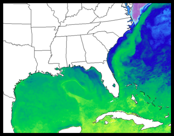
SPoRT MODIS Sea Surface Temperature composite
One of the limitations of the MODIS Sea Surface Temperature product is that clouds often obscure a complete view of the land or ocean surface over a particular geographic region. Therefore, the SPoRT Center creates composite sea surface temperature (Haines et al. 2007) images from the standard MODIS Sea Surface Temperature provided by the University of South Florida. The SPoRT algorithm creates a detailed and spatially continuous sea surface temperature field that simultaneously minimizes cloud contamination and latency effects. This product has been used in support of real-time data assimilation and diagnostic studies for several coastal National Weather Service partners.
