Additional GOES Sounder Imagery in D-2DInstructions for AWIPS InstallationSpace Science and Engineering Center
|
|
| Project members: Scott Bachmeier, Russ Dengel, Jordan Gerth, Scott Lindstrom, Jerrold Robaidek, Steve Wanzong | |
Phase One (Flagship)
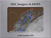
Additional products included in this phase: CAPE, Total Column Ozone
Bandwidth usage: 48 compressed files arrive via Local Data Manager (LDM) daily
Schedule
- October 4, 2006: Phase initiated
- October 10, 2006: Assure data feed to CRH approved, running
- October 13, 2006: Test products created and displayed locally
- October 19, 2006: Sounder image testing completed
- October 20, 2006: Release of scripts for internal review
- October 24, 2006: Final preparation of installation scripts
- October 26, 2006: Official release of Version 1.0
- December 21, 2006: Official release of Version 1.01
- March 29, 2007: Official release of Version 1.1
Offices are strongly encouraged to register with the Local Applications Database (LAD).
The Space Science and Engineering is not staffed around the clock. Consequently, data outages and processing issues may result. These images should be considered non-operational.
Any site which wishes to download this package should be aware that the files and scripts are considered final, but the images pulled from the LDM are non-operational. Weather Forecast Offices which wish to be test sites for future upgrades and phases should contact Jordan Gerth.
- Files and Scripts [eastConus] (GOESpack.tar.gz, via FTP server)
- Files and Scripts [westConus] (GOESpackWEST.tar.gz, via FTP server)
- Documentation (GOESinstall.pdf, via FTP server)
- infoPages [eastConus] (html-add-goesE.tar.gz, via FTP server)
- infoPages [westConus] (html-add-goesW.tar.gz, via FTP server)
- Change Notice for 1.1 (KeyNumChange.pdf, via FTP server)
Known Pitfalls
- The localization install script assumes local files in /data/fxa/customFiles have the WFO identifier as the first three characters of the file name (LLL-).
Further Reading
- None currently
Installation
The GOES data feed is currently served to offices solely in the Central Region.
Are you in the Western Region or Eastern Region and want GOES? Contact Jordan Gerth.
The following sites have successfully installed additional GOES imagery in AWIPS:
- Milwaukee/Sullivan, Wisconsin - KMKX - December 21, 2006 (Phase One)
The following sites have planned to install additional GOES imagery in AWIPS:
- None currently
Screenshots
Courtesy of Scott Bachmeier (contact)
Related Links

