Estimating Thunderstorm Height Trends from Radar and Satellite Observations

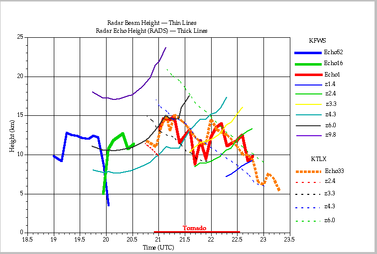
Time series of radar echo (30 dbZ) height and center beam heights at echo location from Ft. Worth, TX (KFTW) and Twin Lakes, OK (KTLX) radars.
These plots illustrate the uncertanties in determining echo height given the discrete elevation intervals used operationally by the WSR-88D radars. The uncertainty introduces ambiguity in time-trends of echo height when echoes are moving toward or away from the radar. In some cases, the echo height appears to "oscillate" between adjacent elevations. Nevertheless, the large-scale trend of the echo heights are similar as observed simultaneously from the 2 radars. The highest altitude (15 km) is observed just after 21 UTC around the time of first tornadic activity.

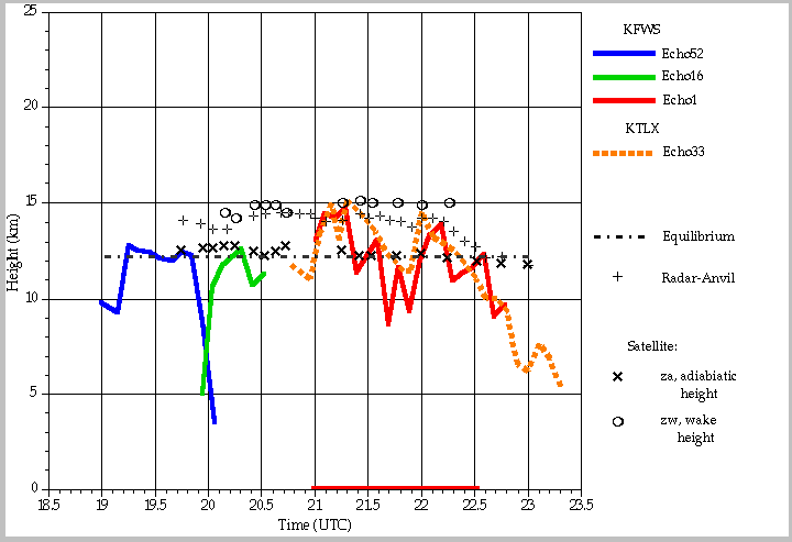
Time series of radar echo height, equilibrium and anvil height, and storm top heights estimated using satellite cloud top temperatures (adabatic and wake methods).
The equilibrium level is estimated from afternoon surface equivalent potential temperature and an average sounding from 23 UTC. This is the height above which a buoyant plume rising from the boundary layer becomes colder than the environment. Assuming no mixing and precipitation loading, the storm updraft would be expected to begin rapid deceleration and anvil formation above this height. The 30 dbZ echo first becomes significantly higher than the equilibrium level at 21 UTC, about the beginning of tornadic activity. The anvil height is estimated from radar reflectivity pattern surrounding the echo. This is generally about 2 km higher than the estimated equilibrium height. These heights appear to reflect the long-term trend of the 30 dbZ echo. There is a rapid increase around 2030 UTC, about 15 minutes after new growth of a 30 dbZ echo. The increase of the 30 dbZ echo at 2115 UTC is hardly reflected in the anvil height. The adiabatic method is based on the same updraft from the equilibrium model rising adiabatically. The height is computed from the cloud top temperature along this adiabat. Since the method assumes no mixing, it is a mimimum estimate of cloud height. The wake method applies results from the Adler and Mack (1986) parcel model using the observed wake and echo top temperature and an average temperature profile from soundings. This method requires no assumption about mixing or updraft strength. The heights are generally 2 km higher than estimates from the adiabatic method and are quite close to the highest 30-dbz echo height during the entire period. Significantly, there are periods where the 30 dbZ echo height is 2-3 km lower than this height. In general, the temporal variation of height from either satellite methods is much lower amplitude than that of the 30 dbZ echos.
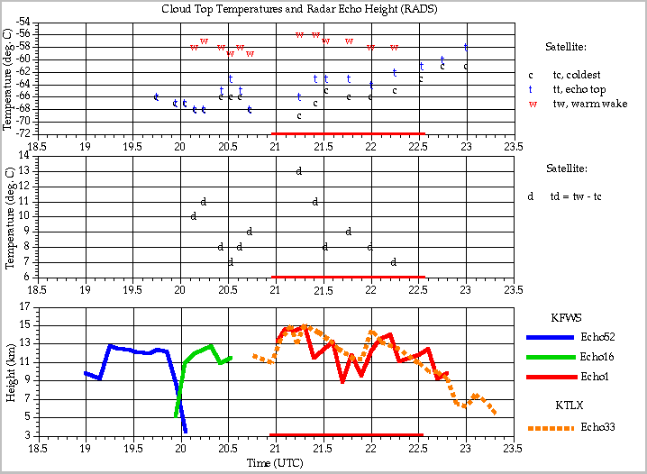
 Time series of radar echo height and cloud top temperature features from GOES-8
The coldest cloud top within the "V" shaped feature, the maximum temperature in the warm wake, and the temperature above the radar echo core (echo top) are shown. In general, this latter temperature is 2-3 degrees warmer than the minumum temperature suggesting the cold point offset of class 3 storms (Adler and Mack, 1986). The temperature difference between the minimum and warm wake are also plotted in this figure. This difference varies between 7 and 13 degrees. Its trend and that of the minimum temperature appear directly related to the trend in echo heights. Peaks occur at 2015 and 2115 UTC. (Note the uneven distribution of satellite observations. No data is available between 2045 and 2115 in the operational mode of GOES-8 due to full disk scans).
A more detailed report on these studies will be available at:
http://www.nssl.noaa.gov/srad/pubs/cldtops.html

