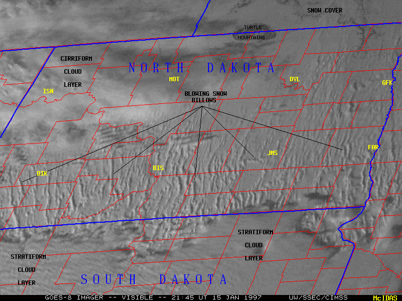
15 January 1997 -- Blowing snow across North Dakota
|
|
|
Atmospheric phenomena such as smoke, dust and haze can be thick enough and possess enough vertical extent to cast shadows, especially during times of low sun angle (in this case, late afternoon in winter at mid latitudes). These particular shadows stand out even more since they are against a white (snow pack) background (the average snow depth across North Dakota that week was about 20 inches). Forward scattering of light during favorable late afternoon sun-satellite geometry enhances the appearance of the blowing snow bands, especially with the contrast stretch enhancement applied here. In addition, the higher 10-bit precision and improved signal-to-noise ratio of the GOES-8 data allows subtle features such as these to be more readily detected.
Discussion with Daniel Noah (Warning Coordination Meteorologist, NWS, Bismarck ND) revealed that there were some small cumulus clouds embedded within some of these bands of blowing snow, near the top of the well-mixed boundary layer. Outside of these blowing snow bands the sun was visible and horizontal visibility was about 4-6 miles, but visibility was reduced significantly as each band of blowing snow passed through. These features showed up well on Bismarck and Minot ND WSR-88D radars, with the features moving like snakes as they kept the same length.
The precipitation gauge at Bismarck recorded 1.0 inches of snow (0.07 inches of water equivalent) between 14:50 and 21:50 UT that day, but most of that was prior to this sequence of imagery (when the stratiform cloud layer was still moving southward across North Dakota into South Dakota). During the time frame of the image animation above (19:45-22:15 UT) 0.2 inches of snow (0.02 inches water equivalent) was captured by the gauge. Whether this precipitation was falling snow or blowing snow is open to some uncertainty. Since this freshly-fallen snow was relatively dry (14:1 snow-to-liquid-water ratio) it was easily picked up from the surface by the strong and persistent winds.
Having lived in South Dakota during my formative years, I've had the dubious privilege of enduring many ground blizzards. While driving during such conditions, I recall seeing the "banding" phenomena on a smaller scale -- snow tends to blow across roadways and open fields in focused bands as opposed to a continuous sheet, and visibility fluctuates dramatically within short distances (1/4 to 1/2 mile or so) as regions of intense blowing snow are encountered. The end results of these blowing snow events look something like this or this.