Blowing snow across Iowa

Another case of blowing snow was noted across Iowa during 27 Jan 1997 [also see NOHRSC AVHRR false-color composite imagery]. Much of Iowa received 1-2 inches of light snow early in the day, followed by northwesterly winds of 15-25 knots (gusting to 36 knots) as an area of high pressure moved into the northern Plains. ASOS surface visibilites were in the 1-4 mile range, with 1/2 mile being reported in parts of northcentral Iowa (Iowa State Police reported visibilities of 1/8 mile or less over northcentral Iowa).

A telephone call to the Des Moines/Johnston NWS forecast office around 22:45 UT revealed that no clouds were visible in the sky -- only blowing snow and sun dogs. The following day I heard from Karl Jungbluth (the NWS Science and Operations Officer at Des Moines), who was off duty on 27 January but was outside observing the skies that day. He reported that some fractus clouds were seen infrequently at the top of the well-mixed blowing snow layer.

It is interesing to note that some ASOS reports also indicated haze along with the blowing snow:

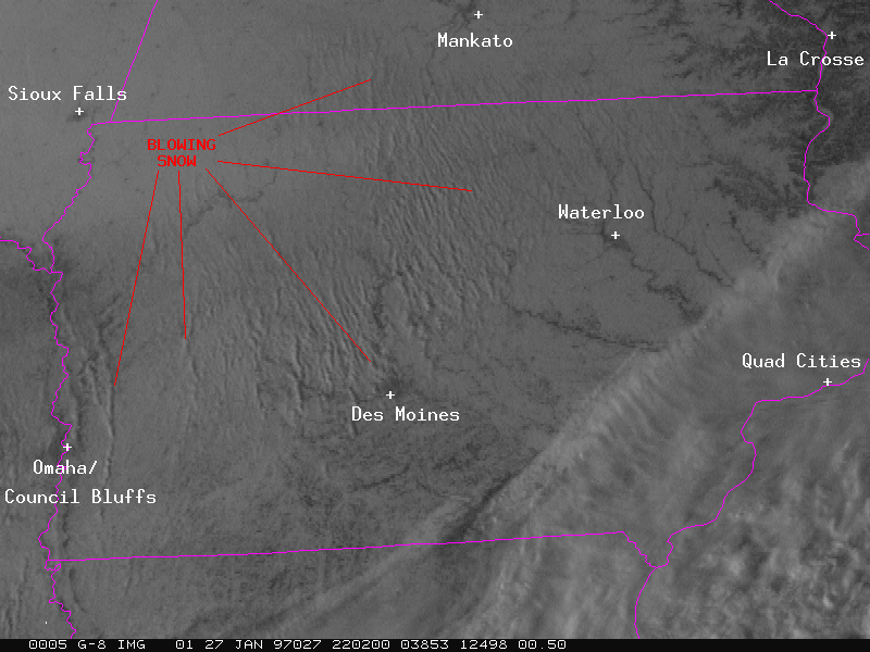
KSUX 272055Z 32022G26KT 3SM BLSN HZ CLR M18/M22 A3059 RMK AO2 PK WND 32032/2011 SLP388 T11831217 53017=

KEST 272108Z AUTO 31021KT 1 1/2SM HZ BKN013 M19/M23 A3044 RMK AO2 PK WND 31026/2054 UPE04 FZRANO TSNO PNO=

Karl mentioned that the sky appeared "dingy" that day, and he could see the well-defined top of the mixed layer (about 0.5 km) just below the strong low-level temperature inversion.


North Dakota blowing snow case | Back to the CIMSS GOES Gallery