


Contributors: Scott Bachmeier, Wayne Feltz, Rhett Grauman, Jun Li, Paul Menzel, Tim Schmit, Tony Schreiner, Dave Stettner, Chris Velden, Gary Wade, Steve Wanzong, Mike Weinreb, Fred Wu
1. Preamble [ Back To Top ]
At the Cooperative Institute for Meteorological Satellite Studies (CIMSS), there were three main goals for the GOES-10 science test (March 16 - April 12, 1998). First, the quality of the GOES-10 data was investigated by comparing the GOES-10 Imager to Sounder, as well as comparing GOES-10 to GOES-8. Second, products from the GOES-10 data stream were successfully produced in real-time and compared to those produced from other satellites; these products include: temperature/moisture retrievals, total precipitable water, lifted index, cloud-top pressure, sea surface temperatures, and satellite derived winds. Finally, the three GOES system was compared to the operational two GOES system to examine their respective advantages and disadvantages.
2. Executive Summary [ Back To Top ]
The science test for GOES-10 produced several conclusions:
- Overall, the satellite data have the same high quality as GOES-8 and GOES-9.
- The GOES-10 imager has less striping, improving the Sea Surface Temperature product.
- While investigation continues into some of the sounder shortwave bands, the low signal to noise allows single field-of-view retrievals to be generated.
- The GOES-10 five minute imaging schedule allowed study of the best time intervals for determining atmospheric motion vectors. Time intervals of 5, 10 and 30 minutes seem best suited for visible, infrared and water vapor winds, respectively.
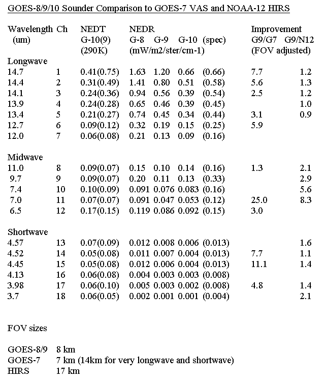
3. Calibration [ Back To Top ]
During the GOES-10 science test period of March 16 - April 12, 1998, the GOES-10
calibration data base was still in the process of being generated and checked. Consequently, the
quality of the calibration was not optimal. The coefficients for the algorithm that accounts for the
scan angle-dependence of the reflectance of the Imager's and Sounder's scan mirrors had not yet
been generated, resulting in GOES-8 coefficients being used. It was not until April 27 that GOES-
10-specific coefficients were made operational. This resulted in an improvement to the calibration.
In addition, many of the calibration data-base coefficients for the GOES-10 sounder, including the
temperature-to-radiance and radiance-to-temperature conversion factors, had been incorrect
because they had been computed from erroneous spectral response functions. Corrected
coefficients were installed at 07 UTC on April 2, 1998, at which time the transmittance model used
to make the retrievals and the quadratic terms in the calibration equations for all channels of the
GOES-10 Imager and Sounder were also updated. This change in the quadratic terms could have
resulted in small changes (usually less than 0.2K) in scene brightness temperatures. In the Imager
visible channel, the image data were not normalized to remove line-to-line striping. However, the
responsivities of the eight detectors in the visible channel are fairly uniform, and striping is
minimal.
Special GOES-10 sounder sectors which include space views allow noise values to be determined by the scatter of radiance values looking at uniform space. Preliminary indications from March 25 at 18:02 UTC show that GOES-10 appears to be the first sounder to be within specification for all the bands. The GOES-10 signal to noise values compared well to those from other satellites.
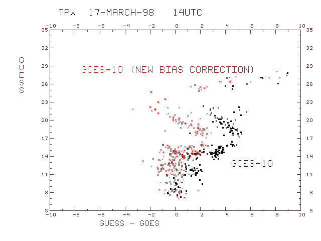
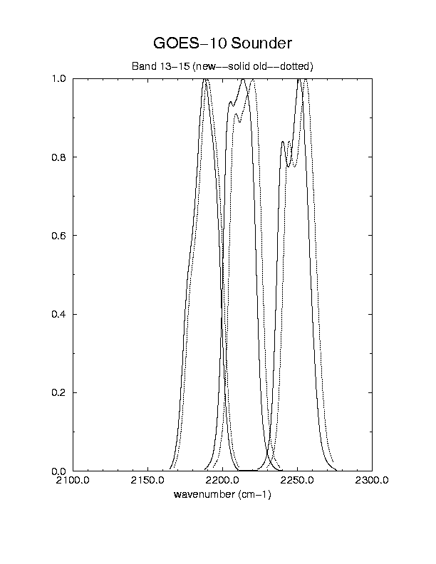
Bands 13 and 15 of the GOES-10 sounder are too cold (by over 6 degrees), compared to GOES-8 sounder data. As a result, the GOES-10 retrievals are too dry (dots). Updating the GOES-10 radiance bias adjustment file helps to mitigate this problem (crosses); differences now look more like the GOES-8 retrievals and the rawinsondes (not shown).
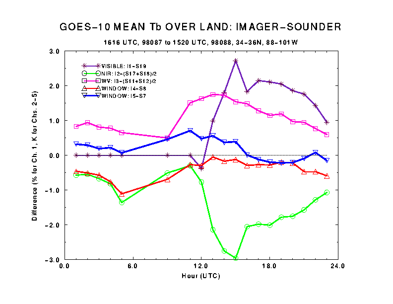
These plots show the mean differences of GOES-10 imager channels 1-5 and the corresponding GOES-10 sounder bands (imager - sounder). The differences are plotted for each hour during a 24-hour period starting around 1600 UTC on March 28, 1998, over the land and ocean . The area and time were selected such that the imager and sounder view the area within approximately one minute.
For visible channel, the earth appears more reflective to the imager than to sounder. The difference has little day to day variation over ocean. The peak difference over land, which normally occurs around local noon, may vary from 2% (March 28) to 6% (not shown but is hinted in March 29 data from 12-15 UTC) . March 29 is more cloudy (thus higher average albedo) over the land region than March 28. The difference is about 10-15% of the average albedo over land and 20-30% over ocean.
There is no sounder band that corresponds well to imager Channel 2 (near IR, 3.9 micron). Instead, the average of sounder bands 17 (4.0 micron) and 18 (3.8 micron) is compared with imager channel 2. The difference is small at night and becomes larger during day, due to differential response of each channel to solar reflection. Similarly, the average of sounder bands 11 (7.0 micron) and 12 (6.5 micron) is compared with imager channel 3 (6.7 micron, the water vapor channel).
Finally, the window channels (Channel 4 of imager vs. Band 8 of sounder, and Channel 5 of imager vs. Band 7 of sounder) compare well with each other. The difference is normally within +/- 0.5 degree.
Comparison of GOES-10 Imager with the GOES-8/9 Imagers:
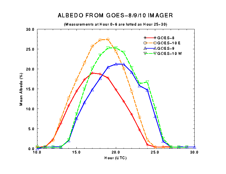
The brightness temperatures (or albedo) of GOES-10 imager channels 1-5 were compared with those from GOES-8/9 every hour for a 24-hour period starting about 0000 UTC, April 1. The comparisons are made over two areas, Midwest (23-53 N, 85-95 W) for GOES-8 and West Coast (23-53 N, 115-125 W) for GOES-9. The latitude bounds are limited by GOES-10 data, and the longitude bounds were chosen so that the pair of satellites view the area with similar angle.
A plot of the hourly visible albedo shows that the daily maximum occurs between satellite noon (1700, 2100, and 1900 UTC for GOES-8, 9, and 10, respectively) and local noon (1800 and 2000 UTC for Midwest and West Coast, respectively). Since reflection is highly directional and the satellites are at different positions, rigorous comparison is difficult. Nevertheless, GOES-10 albedo seems to be 20-50% higher than GOES-8/9 (relative difference, not value of albedo). Incidentally, the spectral response function of GOES-10 imager channel 1 also extends more beyond 0.7 micron than those of GOES-8/9, so part of the difference may be attributed to vegetation reflection. Also, GOES-10 has been in space a much shorter period than GOES-8 or -9.
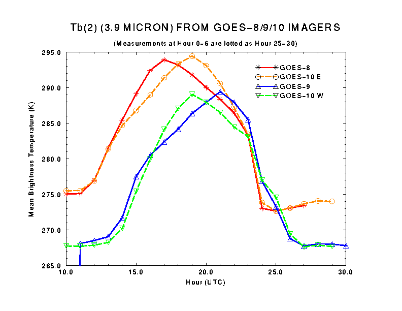
A plot of mean 3.9 micron brightness temperature shows that the daily maxima measured by different satellites have a well identified lag in time, as does the visible channel shown above. Unlike the visible channel, however, the brightness temperatures for each pair of satellites are comparable.
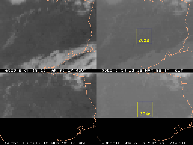
The infrared channels of GOES-10 are compared with those of GOES-8 and GOES-9. The differences are generally less than 1 K, including channel 2 (3.9 micron) at night. The difference in channel 3 (6.7 micron, water vapor) between GOES-10 and GOES-8 is especially small. That, however, could be misleading: on that day, a front was passing the Midwest from west to east such that GOES-8 tends to view the area through the moist side of the front whereas GOES-10 tends to view the area from behind the front.
The most important message from the IR channel differences shown above is that, compared with both GOES-8 and GOES-9, GOES-10 has cooler Tb(4) and generally warmer Tb(5). In other words, the split window brightness temperature difference Tb(4)-Tb(5) from GOES-10 is about 0.8 K smaller than those from GOES-8 and GOES-9. An obvious consequence is that GOES-10 SST using GOES-8 (or GOES-9) coefficients would have a cold bias. It also implies that measurements by GOES-10 split window channels may be less sensitive to variation of atmospheric moisture. It may be interesting to note that the same trend also appears in GOES-10 imager-sounder comparison (see section 3.2 above). Of course these comparisons were made using the GOES-8 coefficients for the algorithm that accounts for the scan angle-dependence of the reflectance of the Imager's and Sounder's scan mirrors.
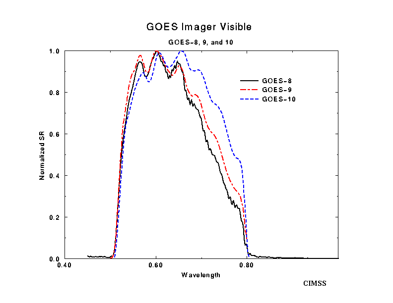
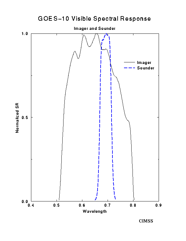
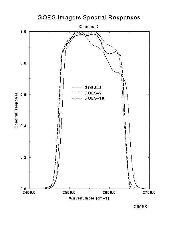
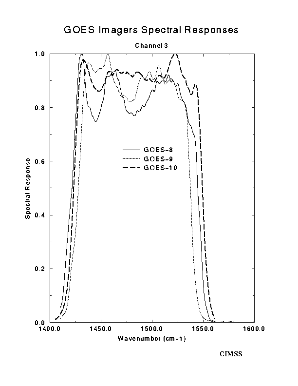
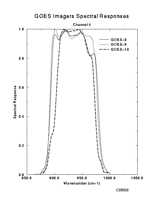
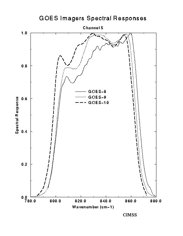
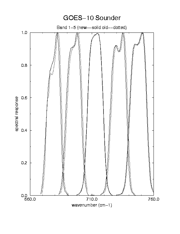
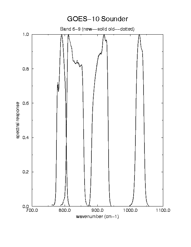
3.5 - Spectral Response Functions
The normalized Spectral Responses give indications of the expected radiance differences between sensors or instruments.
Visible:
- Imager Visible Spectral Responses for GOES-8, 9, and 10
- Imager and Sounder Visible Spectral Responses for GOES-10
IR - Imager:
- Imager Spectral Responses for GOES-8, 9, and 10 (Channel 2)
- Imager Spectral Responses for GOES-8, 9, and 10 (Channel 3)
- Imager Spectral Responses for GOES-8, 9, and 10 (Channel 4)
- Imager Spectral Responses for GOES-8, 9, and 10 (Channel 5)
IR - Sounder:
("New" denotes the updated Spectral Response functions)
- Sounder Spectral Responses for GOES-10 (Bands 1-5)
- Sounder Spectral Responses for GOES-10 (Bands 6-9)
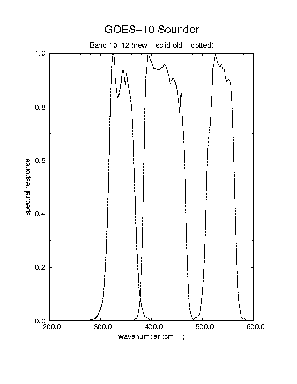
- Sounder Spectral Responses for GOES-10 (Bands 10-12)
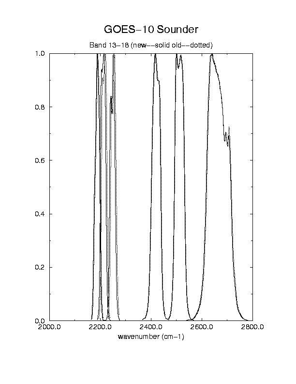
- Sounder Spectral Responses for GOES-10 (Bands 13-18)
- Sounder Spectral Responses for GOES-10 (Bands 13-15)
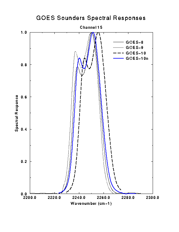
- Sounder Spectral Responses for GOES-8, 9, 10 and 'new' 10 (Band 15)
4. Products [ Back To Top ]
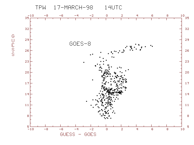
4.1 - Moisture RetrievalsThe following table shows the statistical results of GOES-10 retrieval-rawinsonde matchups for the period 04/02/98-04/12/98. As such, this period encompasses the time frame after which the calibration coefficients for GOES-10 had been updated. The numbers shown are in units of millimeters of precipitable water. The first guess information for each retrieval was generated from an Eta model forecast. In order for a particular retrieval to be included in the statistics, it was required to lie within 0.25 degrees latitude of a nearby rawinsonde. It is quite likely that situations arose where more than one retrieval was verified against the same rawinsonde. Both 00 UTC and 12 UTC statistics are included in the table.
Looking at the RMSD (Root-Mean Square of the Difference between guess and rawinsonde, or retrieval and rawinsonde) column, one can see the retrievals improved the first guess for all but one layer (WV1) at one time (12 UTC) verification. For example, for total precipitable water (12 UTC), there was 0.55mm less scatter for the retrievals about co-located rawinsondes than for the corresponding first guess.
TPW -- Total Precipitable Water
WV1 -- Surface to 0.9 sigma
WV2 -- 0.9 sigma to 0.7 sigma
WV3 -- 0.7 sigma to 0.3 sigma
Sigma is the pressure divided by the surface pressure.
| Parameter | Retrieval Type | Bias | RMSD | RMSE | Num reports |
|---|---|---|---|---|---|
| --------- | ------------ | ---- | ---- | ---- | ------------ |
| TPW | guess- 00Z | 0.46 | 1.98 | 2.04 | 192 |
| ver. 1.75- 00Z | -0.49 | 1.64 | 1.72 | 192 | |
| guess- 12Z | -0.80 | 2.68 | 2.80 | 253 | |
| ver. 1.75- 12Z | -1.12 | 2.13 | 2.41 | 253 | |
| WV1 | guess- 00Z | 0.20 | 1.01 | 1.03 | 192 |
| ver. 1.75- 00Z | -0.16 | 0.85 | 0.87 | 192 | |
| guess- 12Z | -0.69 | 1.28 | 1.45 | 253 | |
| ver. 1.75- 12Z | -0.78 | 1.35 | 1.56 | 253 | |
| WV2 | guess- 00Z | 0.26 | 1.18 | 1.21 | 192 |
| ver. 1.75- 00Z | -0.19 | 1.06 | 1.08 | 192 | |
| guess- 12Z | 0.04 | 1.82 | 1.82 | 253 | |
| ver. 1.75- 12Z | -0.11 | 1.36 | 1.37 | 253 | |
| WV3 | guess- 00Z | 0.00 | 0.75 | 0.75 | 192 |
| ver. 1.75- 00Z | -0.13 | 0.58 | 0.60 | 192 | |
| guess- 12Z | -0.16 | 1.04 | 1.05 | 253 | |
| ver. 1.75- 12Z | -0.23 | 0.75 | 0.79 | 253 |
4.2 - Total Precipitable Water (TPW)
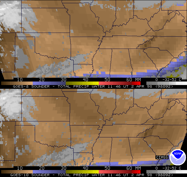
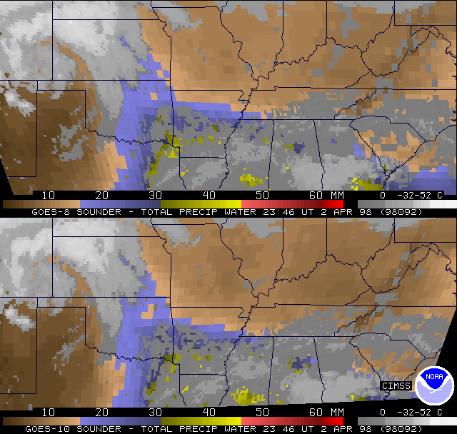
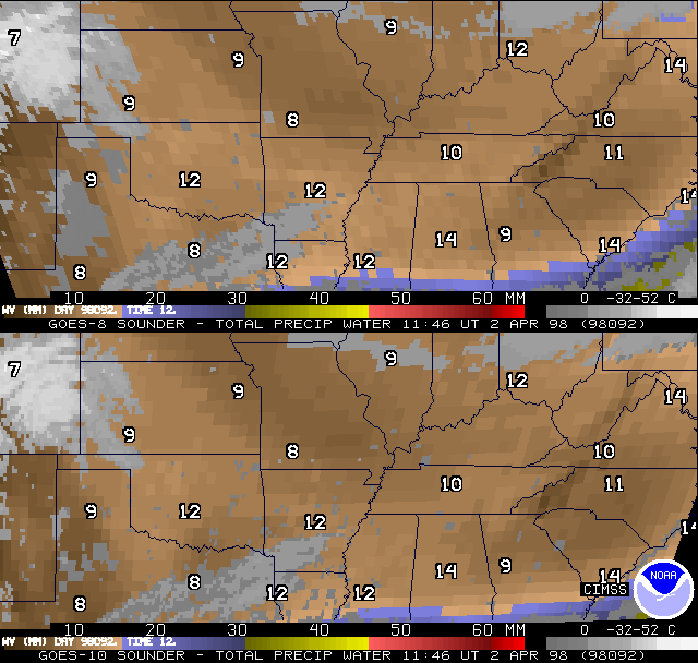
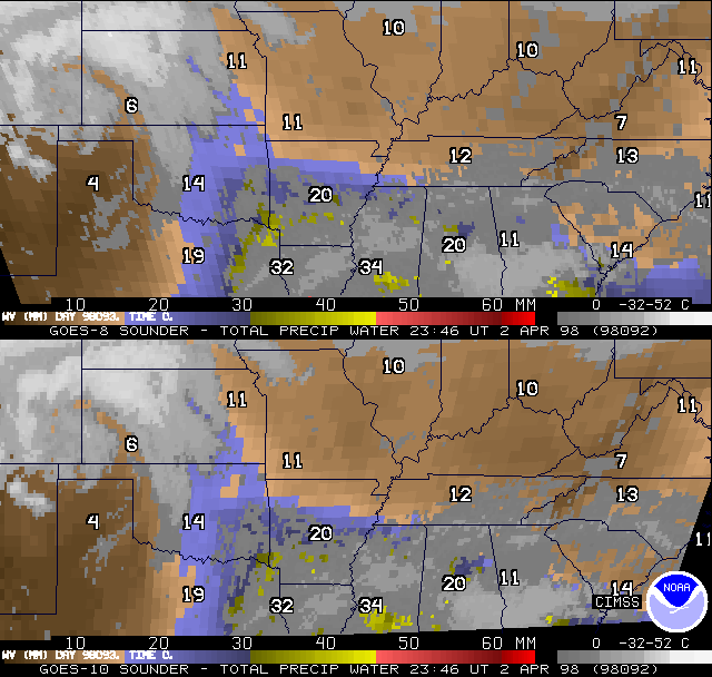
Shown are examples of co-located (Mercator re-map) GOES Sounder DPI for both GOES-8 and GOES-10 over the south central US.
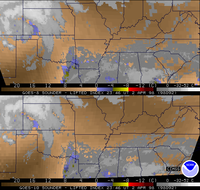
The return flow of moisture during the day on April 2, 1998 from Georgia across to eastern Texas and northward to eastern Kansas is evident, as the total precipitable water (TPW) Derived Product Images (DPI) between 11:46 UTC and 23:46 UTC show. Similar comparisons with 11:46 UTC and 23:46 UTC rawinsonde values overplotted also show that the GOES-8 and GOES-10 products are essentially the same in their overlap region.
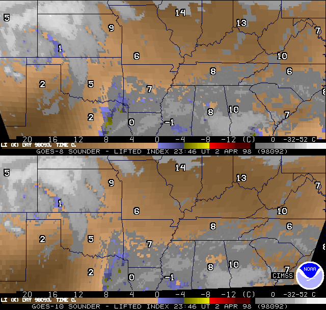
Anticipated de-stabilization across the south central US was rather small as of 23:46 UTC on April 2, 1998. This was observed by the GOES Sounder lifted index (LI) DPI and LI DPI with rawinsonde values. The two satellites again appear much more similar than dissimilar. Convection that first started just after 00:00 UTC was near the Louisiana/Arkansas line, close to the only region showing LI values in the GOES DPI in the 0 to -4C range, despite extensive cloud cover. More convection developed later about 03:00 UTC along the Oklahoma/Arkansas line.
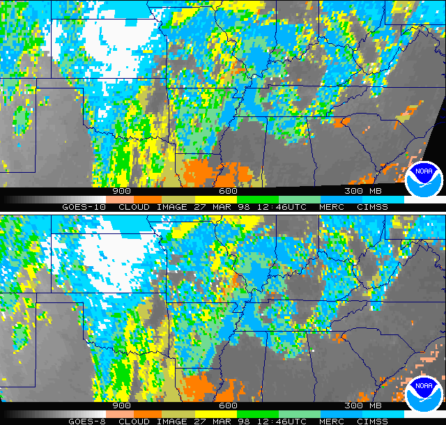
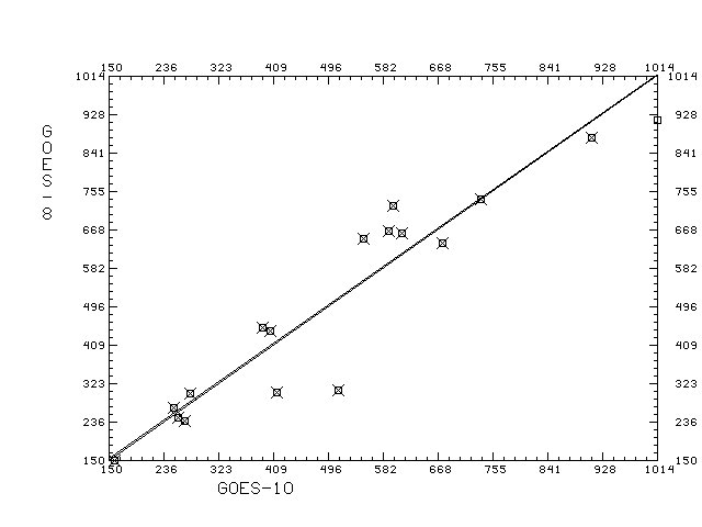
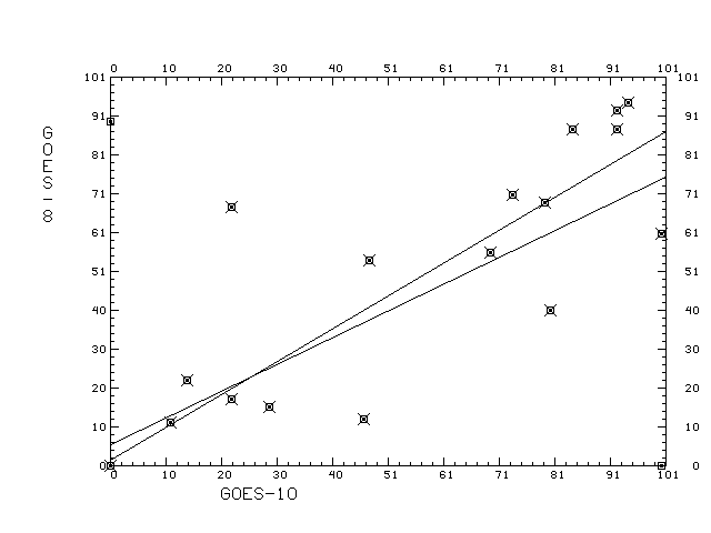
A comparison of GOES-10 and GOES-8 cloud top pressure DPI from March 27, 1998 at 12:46 UTC shows good agreement. Scatter plots show that co-located observations of cloud top pressure for one time period are within 1 hPa on the average. Scatter plots of co-located observations of effective cloud amount for one time period are within 2% on the average. Specific values from these scatter diagrams are found in this table.
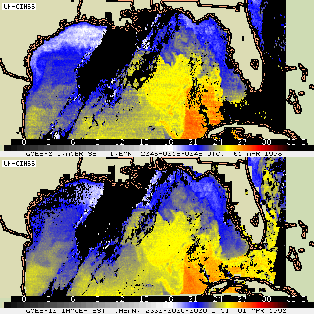
4.5 - Sea Surface Temperature (SST)
Derived by the experimental CIMSS GOES SST algorithm, GOES-8 and GOES-10 sea surface temperatures (SST) from 00:00 UTC on April 1, 1998 over the Gulf of Mexico have been compared. The GOES-8 SST is a regression based on substantial collocations of GOES-8 observations and buoy measurements, while the GOES-10 SST is a regression of GOES-10 observations with GOES-8 SST. Each SST image is the average of three individual SST calculations within one hour, centered at the nominal time indicated, in order to increase the coverage and decrease the noise.
The method for deriving the GOES-10 SST suggests that broad agreement between the two images can be expected. A notable difference is the lack of striping in the GOES-10 SST, which shows as horizontal but otherwise irregular lines in the GOES-8 SST image. This is directly attributable to the improved detector selection characteristics that reduced the effect of the "1/f noise" on striping. Alleviating the striping problem allows the fine oceanic structures to become more evident, such as the remnant of a loop current in western Gulf (south to the Texas-Mexico boundary) and the filamentary feature west of Cuba.
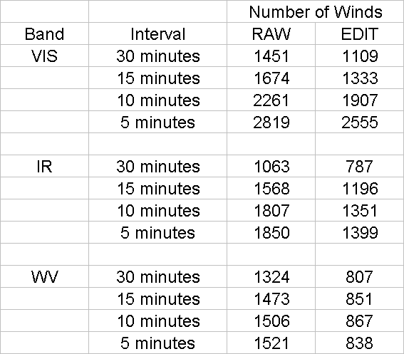
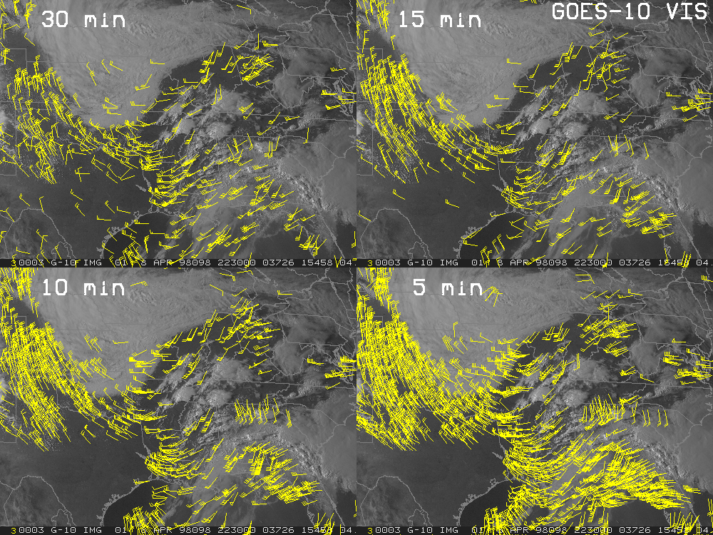
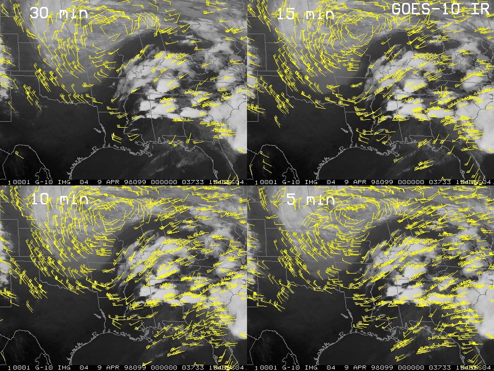
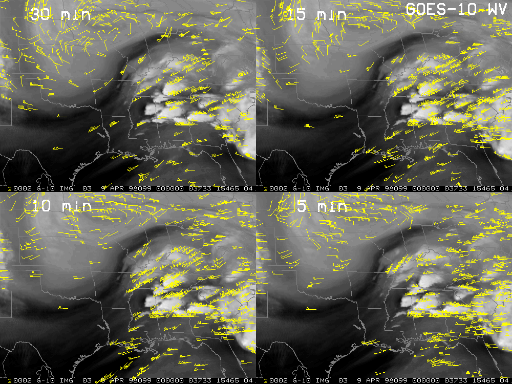
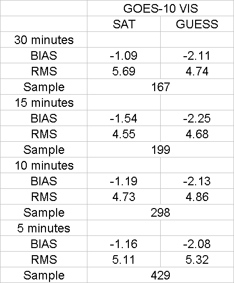
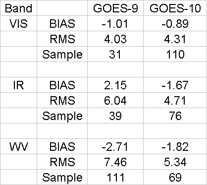
Winds were derived over the central US from the Geostationary Environmental Operational Satellite (GOES) -10 full resolution water vapor, infrared window, and visible images from April 8, 1998 near 23:00 UTC using the CIMSS automated procedures. Our evaluation was aimed at examining the effect of more frequent imaging made possible during the recent GOES-10 science test (nearly continuous 5 minute scans). Three images were used in the wind derivations. For our evaluations, the image spacing was varied at 5, 10, 15, and 30 minute intervals, with the shorter intervals nested inside the longer loops for the best time matching. Based on vector field quantity, quality (coherence), and comparison with radiosonde observations, results indicate that the optimal time interval between images for visible channel low-level winds is 5 minutes, for infrared channel cloud motion winds it is 10 minutes, and for water vapor channel moisture drift in clear skies it is 30 minutes. Operational and demonstrational processing currently uses 30 minute sampling for all bands.
Table 1 shows the vector quantities (raw and after objective editing) derived using the different imaging frequency intervals. There is a remarkable increase in the number of vectors in the VIS and IR channels (factor of 2) when more frequent imagery is used. The percentage of vectors objectively edited is also dramatically reduced, which indicates that the increased quantities are coherent. Little impact is seen with the WV channel. Wind vectors plots for the visible, IR, and water vapor spectral frequencies show the difference between image spacing intervals. Note the increased coherent coverage in the VIS and IR.
Statistical analyses of visible, IR and water vapor datasets (after objective editing) versus rawinsonde verification show that the optimal image processing intervals (windset RMS and BIAS compared to co-located background guess) are 5 minutes for VIS, 10 minutes for IR, and 30 minutes for WV. The high-cloud WV vectors may benefit from the more frequent imagery (as in the IR); however, the clear sky WV tracers are best depicted in the 30 minute intervals currently employed.
Synoptic analysis of the wind fields over the Alabama region shows a much improved depiction of the upper-level jet streak and divergence in the optimized (10-minute loop) IR winds. The short- wave circulation to the northwest of the severe weather outbreak is best described by the clear-sky WV winds at 30 minute intervals. Finally, the 5-minute loop VIS winds clearly show a strong low- level inflow into the developing cells which was not depicted well at the 30 minute image frequency.
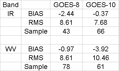
A statistical comparison (vs. radiosonde) of GOES-8/10 and GOES-9/10 windsets (all using a 30 minute image interval) was performed over the same respective domains (no GOES-8 VIS winds were available for comparison). The processing algorithm and methodology were identical. It is demonstrated in this case that the GOES-10 winds are comparable to those from GOES-8/9.
This initial case study demonstrates the ability to extract wind information from GOES-10 and demonstrates the potential value of rapid scan imagery for the derivation of winds from geostationary satellites, particularly for mesoscale applications. A more comprehensive study is underway which will compare the imaging frequencies (as done above) over the entire 4 week test period. This should provide a more firm statistical base for the evaluation. In addition, winds from the GOES-10 sounder WV bands (10 and 11) will be assessed in a similar manner using 15 vs. 30 vs. 60 (now used) minute image frequency.
5. Three GOES Constellation [ Back To Top ]
Having an additional GOES satellite allows for either more rapid coverage of a certain sector, or more sectors to be covered. During the GOES-10 science test the more rapid coverage option was employed. This allowed three images per hour from the sounder, although over a reduced area (due to the relatively slow scan rate).
Using the GOES Sounder to cover more sectors may be more advantageous. This is evident when there are conflicts for the existing two satellite sounder resources, for example during hurricane season. It is then that loops of sounder images are needed for water vapor tracking, along with the other routine uses from numerical model inputs to supplementing the automated ground-based cloud observations. Three sounders would allow all these uses to be satisfied at once. During the non-hurricane season there are opportunities for additional sectors in the southern hemisphere oceans. Additional information for the generally data sparse southern eastern Pacific is more likely to have a positive impact in a global model than any other region of the globe. Currently, no sounder sectors are taken south of the equator.
6. Weather Summaries [ Back To Top ]
During the final 2 weeks of the test period, daily weather summaries were prepared and disseminated via electronic mail to members of the CIMSS and NOAA/NESDIS GOES-10 science test team.
March 29-30 1998
March 30-31 1998
March 31-1 1998
April 1-2 1998
April 2-3 1998
April 3-4 1998
April 4-5 1998
April 5-6 1998
April 6-7 1998
April 7-8 1998
April 8-9 1998
April 9-10 1998
April 10-11 1998
April 11-12 1998
April 12-13 1998
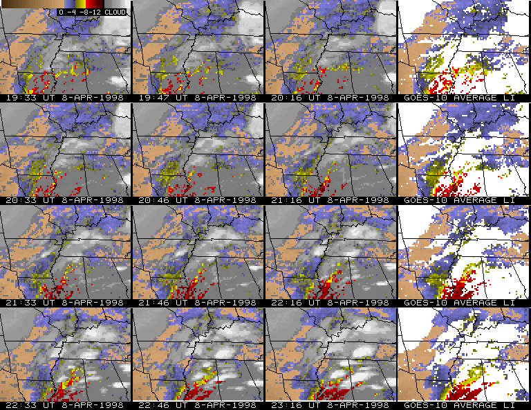
7. Case study: April 8, 1998 Alabama Tornado Outbreak [ Back To Top ]
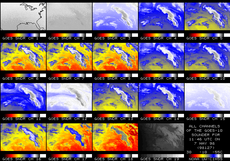
Frequent GOES-10 Sounder DPI over southeastern US from April 1998
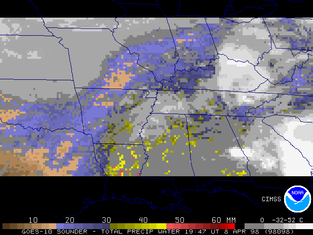
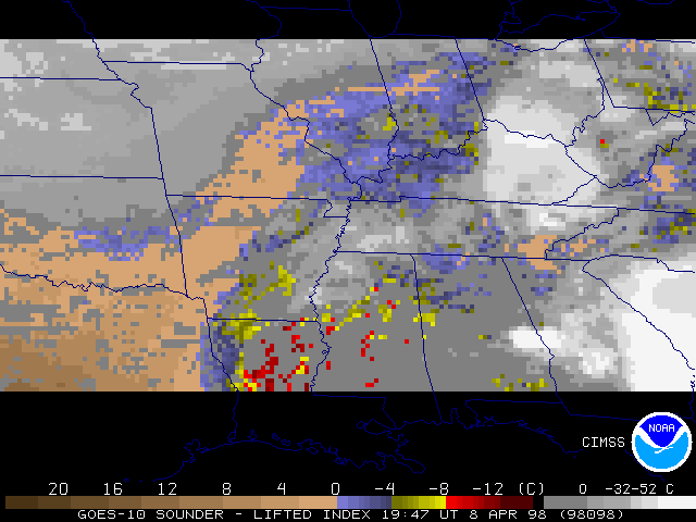
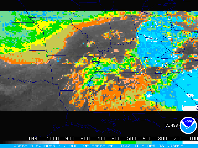
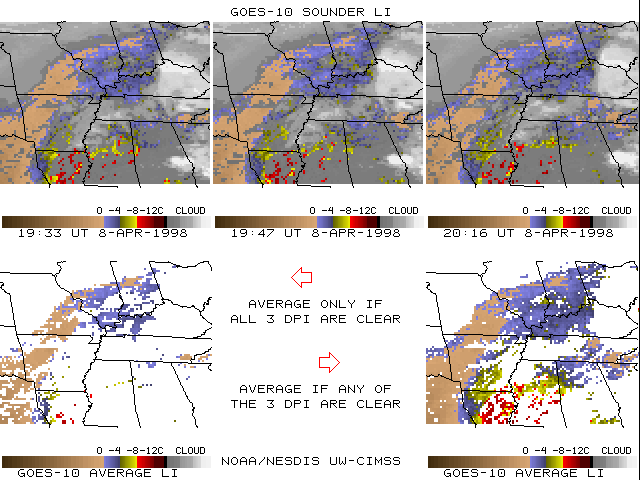
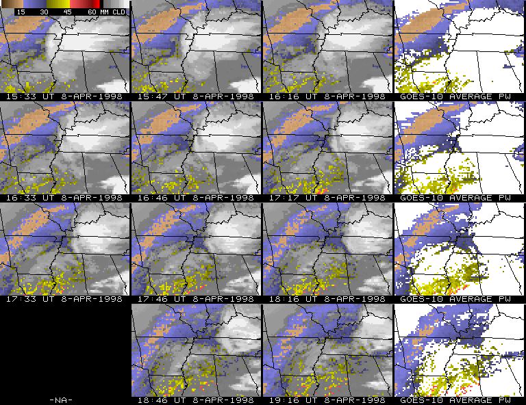
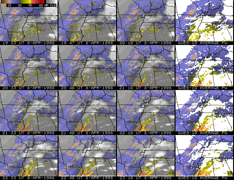
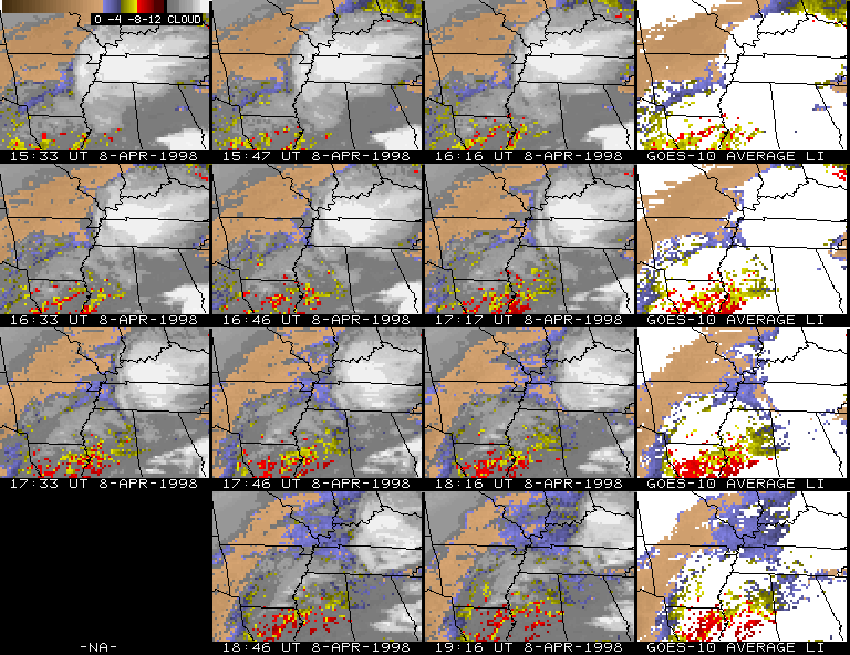
Derived Product Images (DPI) were produced from the special frequent observation schedule of the GOES-10 Sounder during the GOES-10 "science test period". The products generated were: total precipitable water vapor (PW), lifted index stability (LI), and cloud top pressure (CTP). Examples are shown for the late morning and afternoon of April 8, 1998 over the south central Mississippi Valley. The spatial resolution of these DPI is at the full resolution of the Sounder instrument (nominally a 10 km field-of-view (FOV) at the sub-satellite point). The temporal resolution was maximized at a nominal interval of approximately 15 minutes, but only three views occurred per hour; the actual start scan times were at xx:33, xx:46, and xx:16.
The frequent viewing at 15 minutes does allow for compositing a few DPI together to increase the clear FOV coverage, as broken and scattered clouds move through the region of observation. An example of lifted index for 19 UTC shows extremes of averaging the three periods: either requiring a FOV to be clear for all three times or allowing any combination of times, including at least one clear period. The lower right panel shows considerably more coverage, about one third of the entire area viewed, compared to only a small fraction, as seen in the lower left panel, where all periods must be clear. The increased coverage does not seem to have come at the price of poorer quality, as the additional LI values do not appear any noisier. The good radiometric performance of the GOES-10 Sounder encourages the generation of the DPI at single FOV resolution. Restriction of time averaging to only using all three periods, for improving signal to noise ratios, does not seem advantageous.
Multi-panel displays of PW ( individual and time-averaged ) and LI ( individual and time-averaged ) DPI for each hour, ordered in four hour blocks, illustrate the consistency of the DPI fields, at both 15 minute and hourly intervals. The challenge of attempting, amidst clouds, to sufficiently determine patterns of stability or moisture from an infrared sounder is very evident in the early sequences, as clouds obscure the majority of the region. However, as the afternoon progresses, clearing (and heating) replaced cloudiness over the southern Arkansas/northern Mississippi area. The GOES LI DPI showed, from an LI value of -6C at the initial hour, instability increasing to -10C at 18 UTC and plateauing at -11C for the last two hours over south central Mississippi. Moisture was ample, with PW values to 45mm. By 22 UTC, convection erupted in central Mississippi, just on the edge of the very unstable and moist air that had been persistently depicted in the DPI. The strong (100+ kt) upper level west south-westerly flow over that region helped to quickly move those storms into north central Alabama within the next few hours, including the deadly tornadic storm that hit Pleasant Grove, just west of Birmingham (AL) shortly after 00 UTC. The high values of available atmospheric instability and moisture seen in the DPI supported the tornado watch boxes forecast by SPC for that afternoon and evening over Mississippi and Alabama.
The following sequences illustrate how the more frequently available DPI provide a smoother evolution of the parameter patterns (as would be expected). More frequent looks also do increase coverage if composited as shown above. However, a more significant advantage from the more rapid observations is not clearly evident. First-guess dependence of the profile retrieval algorithm, especially considering the use of only hourly surface reports, limits how successfully very small (though correct) changes in observed radiances each 15 minutes can be translated into significant changes in atmospheric parameters which would affect forecast decisions.
Animations (in FLI format) are available as indicated below, contrasting the frequent "15 minute" data with that which had typically been available previously, just once per hour. The hourly cycle is what is currently available with the GOES-8 and -9 Sounders. The temporally averaged DPI (from any of the three available in a one hour period) are also animated for PW and LI, presently an evolution of the parameter pattern with a more obvious signal (due to the increased coverage). The time range is nominally from 16 to 23 UTC (on April 8, 1998).