Southern Californias Santa Ana winds
are lengendary for the
hot, dry conditions they create every year. Along with an increase
in fire hazards, they produce high waves, strong surfs,
treacherous
conditions
for boaters and pilots, and damage to
people's property.
Santa Ana winds occur in the Los Angeles
basin below the passes and canyons
of the coastal ranges of Southern California.
What
typically gets them started is an area of atmospheric High pressure
over the southwestern United States. The High pressure forces
air downslope from the dessert plateaus into the coastal mountain ranges
where it begins to pick up speed. As the wind speeds up, it dries
out and warms up as it heads toward the California coast.
Satellites are helping scientist study the Santa Ana winds with more
detail. This derived image (below) was produced using data from the
SeaWinds instrument aboard NASAs Quick Scatterometer (QuikSCAT) polar
orbiting satellite.
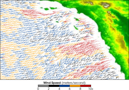
The image shows strong winds blowing offshore all along the Southern
California coast.
The fastest winds are indicated in red, with orange,
blue, black, and gray representing progressively slower wind speeds.
(10 meters per second = 22.4 miles per hour)
