Date: Dec 07, 2002
Mission: Aqua L1B and Cloud validation.
Mission Objectives
Collect clear scenes over snowcover, low cloud over snowcover, thin cirrus over snowcover to assess Aqua cloud mask and cloud product performance under these conditions. Collect co-incident uplooking and downlooking lidar over ARM SGP for cloud studies.
Flight Summary
Take-off at 1655 UTC. ER-2 landed at 2110 UTC.
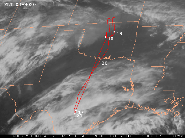
ER-2 flew north from SAT to N. OK to begin flying 4 parallel line (12 min lines) sequence at SW corner (all lines parallel to Aqua orbital track w/12 nm spacing). SGP Central Facility (CF) positioned at middle of 2nd line (first overflight at ~1824 UTC). Skies cloudy with cirrus on transit through TX, then clearing in central OK before becoming cloudy with low stratus on data lines (90% coverage with low stratus; some clear sky at very southern end). Low stratus had almost entirely covered snowcover region in N. OK. Surface features at times visible through thin low stratus in MAS imagery (e.g. 1918 UTC). Occasional cirrus filament above the low stratus. Flew all 4 lines on 1st sequence, went back to start point and began 2nd sequence, flying the first and 2nd lines overflying the CF at 1933 UTC (10 minutes before Aqua). Pilot extended 2nd line southward along Aqua orbital track into central OK where there was single layer thin cirrus and clear sky for Aqua overpass at 1943 UTC. Flew in clear sky for about 6 minutes after Aqua overpass (1943-49 UTC). Then adjusted course and returned to SAT, overflying thin and thick cirrus in TX.
Highlights
Single layer thin cirrus w/Aqua. Clear sky w/Aqua in central OK. Well defined multilayer cloud (ice over water) near Aqua overpass time.
Instrument Status
Additional Pilot Notes: Surface obscured on 90% of data legs.
No observations of snowcover. No turbulence. Wave structure
to stratus cloud.