Index of /satellite-blog/images/2025/10
Name
Last modified
Size
Description
Parent Directory
-
251003_goes18_ngfs_CA_refinery_fire.mp4
2025-10-07 02:26
201M
251009_goes18_infrared_totalPrecipitableWater_glmFlashPoints_American_Samoa.mp4
2025-10-10 15:40
99M
251001_goes19_visible_infrared_glmFlashPoints_Imelda.mp4
2025-10-03 16:07
95M
251011_251012_goes18_waterVapor_peakWindGusts_AK.mp4
2025-10-13 17:32
84M
251001_goes19_infrared_Imelda.mp4
2025-10-03 16:07
72M
GOES-19_ABI_RadF_true_color_2025277_170020Z.tif.jpg
2025-10-06 12:46
53M
GOES-19_ABI_RadF_cimss_true_color_2025277_170020Z.tif.jpg
2025-10-06 12:44
45M
251003_goes18_nearInfrared_shortwaveInfrared_Ca_refinery_fire.mp4
2025-10-07 02:26
11M
251012_0400utc_goes18_waterVapor_peakWindGusts.png
2025-10-13 17:32
4.8M
G16B13-20220705_2001_to_2256anim.mp4
2025-10-09 18:32
4.7M
251012_1000utc_goes18_waterVapor_paehPeakWind75.png
2025-10-13 17:32
3.6M
251012_0700utc_goes18_waterVapor_papbPeakWind80.png
2025-10-13 17:32
3.6M
251012_1900utc_goes18_waterVapor_pamkPeakWind70.png
2025-10-13 17:32
3.3M
251012_1000utc_g18_wv_winds.png
2025-10-13 17:32
3.1M
251012_0700utc_g18_ir_winds.png
2025-10-13 17:32
3.1M
251012_1424utc_suomiNPP_viirs_infrared_dayNightBand_Typhoon_Halong_remnants_anim.gif
2025-10-13 19:42
3.0M
PSv3Readout5July2022_2000_to_2200step.mp4
2025-10-02 19:42
3.0M
251003_1625utc_goes18_microphysicsRGB_ngfsFireDetections.png
2025-10-04 16:48
2.9M
251012_1900z_g18_wv_winds.png
2025-10-13 17:32
2.8M
251003_0431utc_goes18_ngfs_cursor_sample.png
2025-10-04 16:48
2.2M
251012_surface_analyses_Typhoon_Halong_remnants_anim.gif
2025-10-13 19:42
2.2M
GOES17AshProbability_0906_1301_28Nov_2022.mp4
2025-10-02 18:42
2.1M
251001_goes19_infrared_2100utcShear_Imelda_anim.gif
2025-10-03 16:07
1.9M
251001_goes19_infrared_1700utcShear_Imelda_anim.gif
2025-10-03 16:07
1.8M
251012_1424z_snpp_ir.png
2025-10-13 17:32
1.8M
251012_1424utc_suomiNPP_infrared_peakWindGusts.png
2025-10-13 17:32
1.8M
251003_0431utc_goes18_ngfs.png
2025-10-04 16:48
1.8M
251008_251011_surface_analyses_Typhoon_Halong_North_Pacific_anim.gif
2025-10-13 19:42
1.6M
251012_1424z_snpp_dnb.png
2025-10-13 17:32
1.6M
251012_1424utc_suomiNPP_dayNightBand_peakWinds.png
2025-10-13 17:32
1.6M
251012_1200utc_goes18_waterVapor_paooPeakWind87.png
2025-10-14 00:02
1.5M
251012_1200utc_goes18_waterVapor_paooPeakWind87_zoom.png
2025-10-14 00:02
1.4M
251009_ntsu_metars.png
2025-10-10 15:40
1.3M
251001_1700utc_g19_vis_ir_Imelda.png
2025-10-03 16:07
1.3M
251002_0400utc_g19_ir_Imelda.png
2025-10-03 17:58
1.2M
251001_2100utc_g19_vis_ir_Imelda.png
2025-10-03 16:07
1.2M
251012_1603utc_snpp_dnb_winds.png
2025-10-13 17:32
1.2M
251012_1603utc_snpp_ir_winds.png
2025-10-13 17:32
1.2M
251009_251011_surface_analyses_Typhoon_Halong_West_Pacific_anim.gif
2025-10-13 19:42
1.2M
251012_1200utc_paom_raob.png
2025-10-13 17:32
1.0M
251009_ntsu_raobs_anim.gif
2025-10-10 17:16
1.0M
251009_1200utc_ntsu_raob.png
2025-10-10 15:40
1.0M
251009_0000utc_ntsu_raob.png
2025-10-10 15:40
1.0M
251012_1100utc_goes18_waterVapor_peakWindGusts_raob_sites.png
2025-10-13 17:32
958K
251002_0000utc_txkf_raob.png
2025-10-03 17:58
957K
251009_0300utc_0600utc_surface_analyses_anim.gif
2025-10-10 17:16
565K
1024x1024_GOES-19_ABI_RadF_true_color_2025277_170020Z.tif.jpg
2025-10-06 12:46
461K
1024x1024_GOES-19_ABI_RadF_cimss_true_color_2025277_170020Z.tif.jpg
2025-10-06 12:44
406K
251001_satcon_Imelda.png
2025-10-03 16:07
401K
251003_0431utc_goes18_shortwaveInfrared_firePower_fireTemperature_fireArea_CA_refinery_fire.png
2025-10-04 16:48
395K
251003_0431utc_goes18_nearInfrared_shortwaveInfrared_CA_refinery_fire.png
2025-10-04 16:48
350K
251012_06z_sfc_hal.gif
2025-10-13 18:17
327K
251012_18z_sfc_hal.gif
2025-10-13 18:17
327K
251012_12z_sfc_hal.gif
2025-10-13 18:17
326K
251009_0450utc_g18_ir_tpw_glm.png
2025-10-10 15:40
320K
251009_0400utc_g18_ir_tpw_glm.png
2025-10-10 15:40
320K
251013_00z_sfc_hal.gif
2025-10-13 18:17
319K
251012_00z_sfc_hal.gif
2025-10-13 18:17
312K
251011_18z_sfc_hal.gif
2025-10-13 18:17
311K
251009_0600utc_surface_analysis.jpg
2025-10-10 15:40
207K
251009_0300utc_surface_analysis.jpg
2025-10-10 15:40
207K
251009_1230utc_surface_anaysis.jpg
2025-10-10 15:40
191K
251009_1500utc_surface_analysis.jpg
2025-10-10 15:40
190K
251009_0000utc_surface_analysis.jpg
2025-10-10 15:40
181K
251011_00z_sfc_ha.gif
2025-10-13 18:17
121K
251001_1057utc_dmsp17_ssmis_microwave_Imelda.gif
2025-10-03 16:07
119K
251010_18z_sfc_ha.gif
2025-10-13 18:17
118K
251009_00z_sfc_ha.gif
2025-10-13 18:17
117K
251011_12z_sfc_ha.gif
2025-10-13 18:17
117K
251011_06z_sfc_ha.gif
2025-10-13 18:17
117K
251009_18z_sfc_ha.gif
2025-10-13 18:17
116K
251009_12z_sfc_ha.gif
2025-10-13 18:17
116K
251011_18z_sfc_ha.gif
2025-10-13 18:17
116K
251010_12z_sfc_ha.gif
2025-10-13 18:17
115K
251010_00z_sfc_ha.gif
2025-10-13 18:17
115K
251008_18z_sfc_ha.gif
2025-10-13 18:17
114K
251009_06z_sfc_ha.gif
2025-10-13 18:17
113K
251010_06z_sfc_ha.gif
2025-10-13 18:17
112K
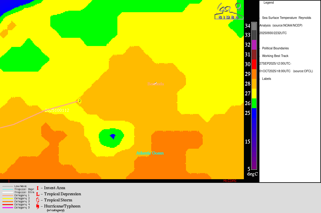
251002_seaSurfaceTemperature_oceanHeatContent_Imelda_anim.gif
2025-10-03 16:17
111K
251002_ohc_Imelda.gif
2025-10-03 17:58
76K
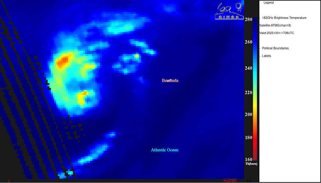
251001_1708utc_atms_microwave_Imelda.gif
2025-10-03 16:07
76K
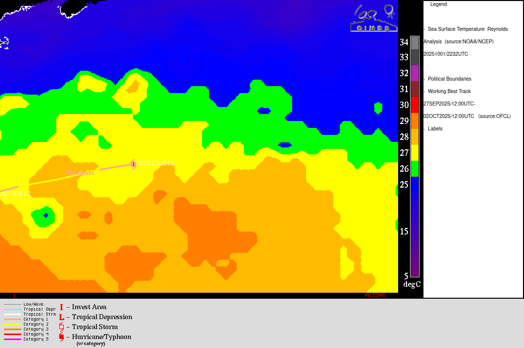
251002_sst_Imelda.gif
2025-10-03 17:58
35K
251001_sst_Imelda.gif
2025-10-03 16:07
24K
251009_nstu_ffw.text
2025-10-10 15:40
1.1K
251008_nstu_ffa.text
2025-10-10 16:32
828