Index of /satellite-blog/images/2021/02
Name
Last modified
Size
Description
Parent Directory
-
210227_kbyz_lsr.text
2021-03-02 18:52
419
210227_goes17_visible_dayCloudPhaseDistinctionRGB_MT_anim.mp4
2021-03-02 16:20
10M
210227_goes17_visible_dayCloudPhaseDistinctionRGB_MT_anim.gif
2021-03-02 16:20
59M
210227_goes16_visible_dayCloudPhaseDistinctionRGB_MT_anim.mp4
2021-03-02 16:20
9.9M
210227_goes16_visible_dayCloudPhaseDistinctionRGB_MT_anim.gif
2021-03-02 16:20
59M
210227_goes16_goes17_cloudPhaseDistinctionRGB_MT_anim.gif
2021-03-02 16:20
1.9M
mt_vis_g17-20210227_190117.png
2021-03-02 16:16
142K
mt_vis-20210227_190115.png
2021-03-02 16:16
280K
mt_rgb_g17-20210227_190117.png
2021-03-02 16:16
197K
mt_rgb-20210227_190115.png
2021-03-02 16:16
372K
210228_goes17_trueColorRGB_AK_Katmai_ash_anim.mp4
2021-03-02 15:54
11M
210228_goes17_trueColorRGB_AK_Katmai_ash_anim.gif
2021-03-02 15:54
102M
210228_0734utc_2121utc_metopC_ascat_Katmai_anim.gif
2021-03-01 20:40
138K
210228_2121utc_metopC_ascat_Katmai.png
2021-03-01 20:38
66K
210228_0734utc_metopC_ascat_Katmai.png
2021-03-01 20:38
50K
210228_noaa20_suomiNPP_viirs_trueColorRGB_Katmai_plume_anim.gif
2021-03-01 20:19
5.8M
210228_2320utc_snpp_tc.png
2021-03-01 20:10
2.1M
210228_2320utc_n20_tc.png
2021-03-01 20:10
2.0M
210228_2137utc_n20_tc.png
2021-03-01 20:10
2.2M
210228_1956utc_n20_tc.png
2021-03-01 20:10
2.1M
210228_PASO_SFCMG.GIF
2021-03-01 16:23
15K
210228_PAIL_SFCMG.GIF
2021-03-01 16:23
15K
210228_PAIL_SFCMG_2.GIF
2021-03-01 16:23
16K
210228_PAHO_SFCMG.GIF
2021-03-01 16:23
15K
210228_PADQ_SFCMG.GIF
2021-03-01 16:23
14K
210228_surface_analyses_AK_anim.gif
2021-03-01 15:40
1.9M
GAMEDE_VIS_loop_2007057_023000_2007057_140000.gif
2021-03-01 14:36
10M
GAMEDE_VIS_loop_2007056_023000_2007056_140000.gif
2021-03-01 14:35
10M
GAMEDE_VIS_loop_2007055_023000_2007055_140000.gif
2021-03-01 14:35
9.9M
GAMEDE_VIS_loop_2007054_023000_2007054_140000.gif
2021-03-01 14:34
9.3M
GAMEDE_IR_MET8_1day_loop_2007056_000000_2007056_234500.gif
2021-03-01 14:33
71M
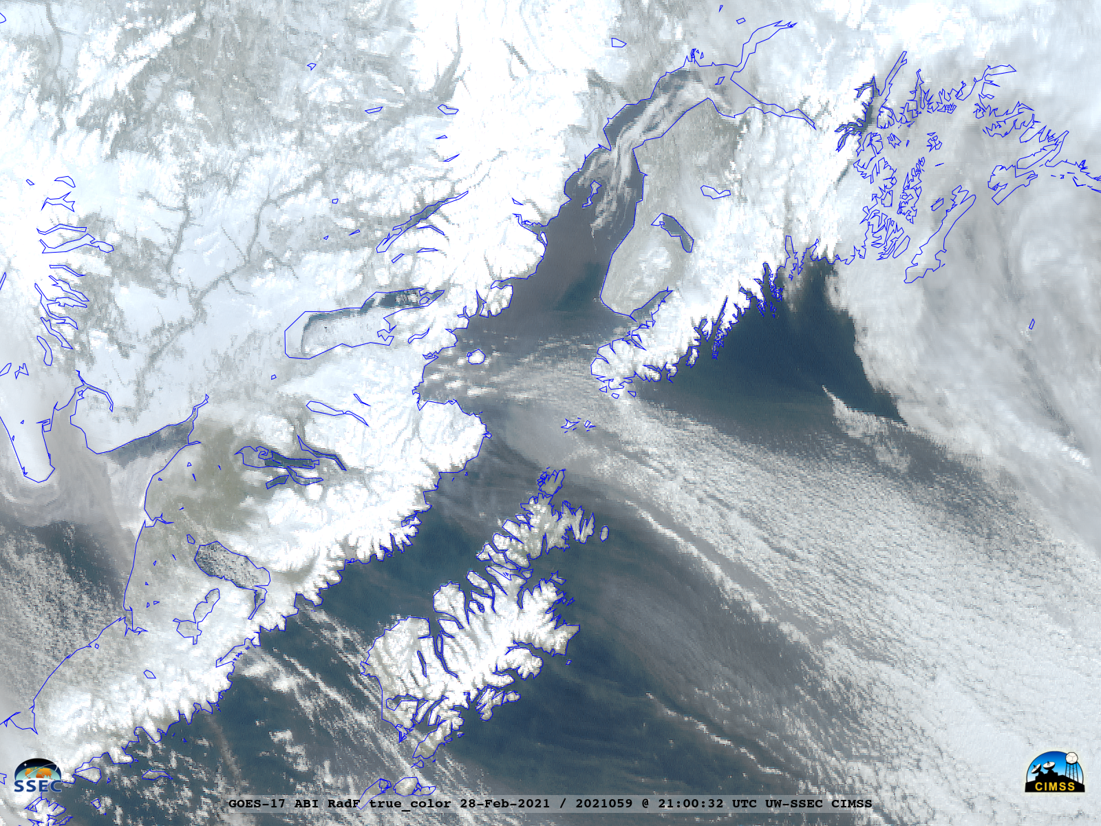
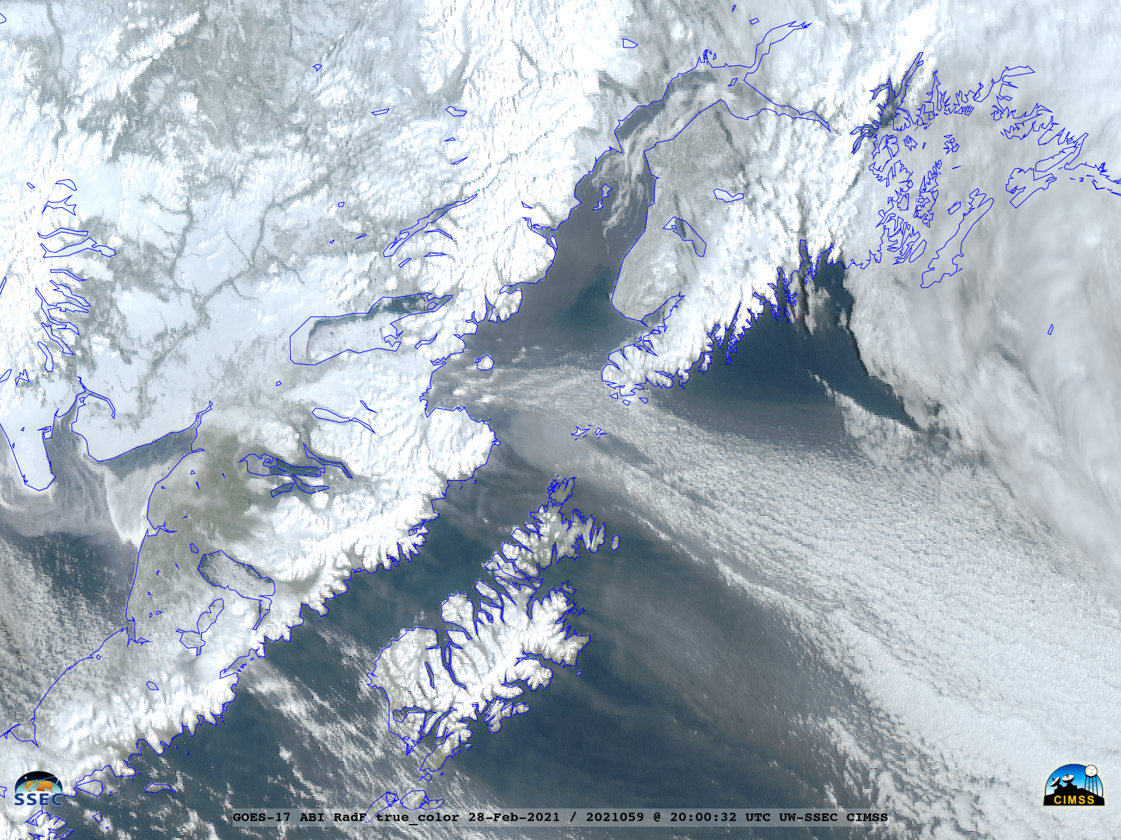
GOES-17_ABI_RadF_true_color_2021059_210032Z.png
2021-03-01 03:30
2.8M
210228_suomiNPP_viirs_dayNightBand_nearConstantContrast_AK_anim.gif
2021-03-01 03:12
3.0M
210228_goes17_visible_AK_Katmai_ash_anim_v2.mp4
2021-03-01 03:12
9.2M
210228_goes17_visible_AK_Katmai_ash_anim_v2.gif
2021-03-01 03:12
172M
ak_vis-20210228_200059.png
2021-03-01 02:58
633K
ak_vis-20210228_210059.png
2021-03-01 02:58
637K
210228_goes17_visible_AK_Katmai_ash_anim.mp4
2021-03-01 02:42
9.2M
210228_goes17_visible_AK_Katmai_ash_anim.gif
2021-03-01 02:42
172M
GOES-17_ABI_RadF_true_color_2021059_200032Z.png
2021-02-28 22:37
3.0M
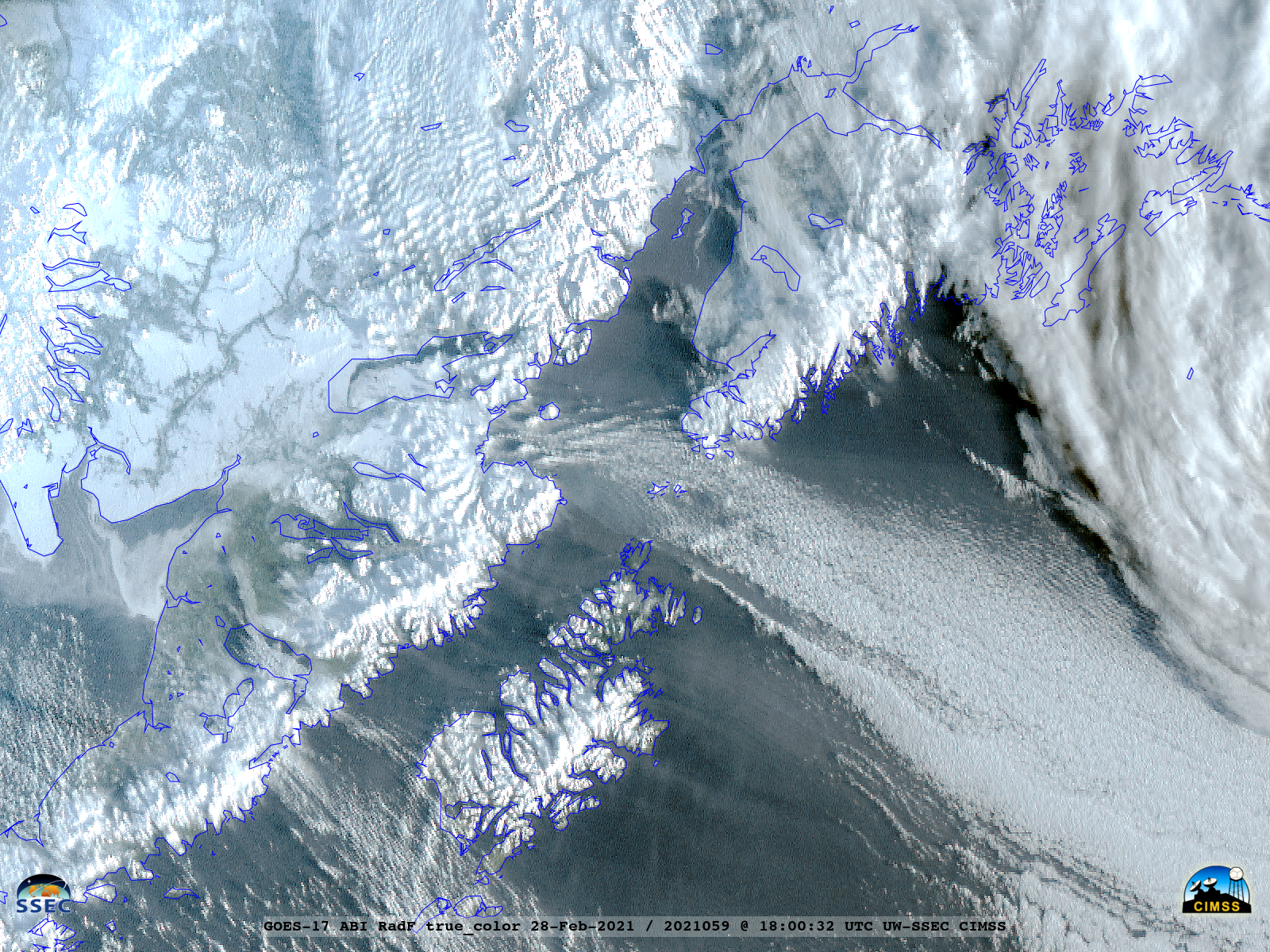
GOES-17_ABI_RadF_true_color_2021059_180032Z.png
2021-02-28 22:19
3.4M
GOES-17_ABI_RadF_true_color_2021059_162032Z.png
2021-02-28 22:15
210K
GOES-17_ABI_RadF_true_color_2021059_160032Z.png
2021-02-28 22:15
210K
GAMEDE_IR_MET8_1day_loop_2007056_000000_2007056_234500.mp4
2021-02-28 17:54
14M
GAMEDE_IR_MET7_4day_loop_2007055_000000_2007058_230000.mp4
2021-02-28 17:44
32M
GAMEDE_IR_MET8_4day_loop_2007055_000000_2007058_234500.mp4
2021-02-28 17:36
39M
GAMEDE_IR_MET8_3day_loop_2007055_000000_2007057_234500.mp4
2021-02-28 17:33
28M
GAMEDE_IR_MET7_3day_loop_2007055_000000_2007057_230000.mp4
2021-02-28 17:31
25M
GAMEDE_VIS_loop_2007057_023000_2007057_140000.mp4
2021-02-28 16:56
2.3M
GAMEDE_VIS_loop_2007056_023000_2007056_140000.mp4
2021-02-28 16:54
2.1M
GAMEDE_VIS_loop_2007055_023000_2007055_140000.mp4
2021-02-28 16:53
2.0M
GAMEDE_VIS_loop_2007054_023000_2007054_140000.mp4
2021-02-28 16:52
2.0M
GAMEDE_IR_MET7_loop_2007053_000000_2007059_230000.mp4
2021-02-28 16:50
28M
GAMEDE_IR_MET8_loop_2007053_000000_2007059_234500.mp4
2021-02-28 16:31
46M
210227_goes17_visible_AK_low_anim.mp4
2021-02-28 01:54
3.8M
210227_goes17_visible_AK_low_anim.gif
2021-02-28 01:54
105M
GAMEDE_VIS_loop_2007054_020000_2007054_143000.mp4
2021-02-27 18:50
1.3M
GAMEDE_VIS_loop_2007055_020000_2007055_143000.mp4
2021-02-27 18:38
1.2M
GAMEDE_VIS_loop_2007056_020000_2007056_143000.mp4
2021-02-27 18:33
1.3M
GAMEDE_VIS_loop_2007058_020000_2007058_143000.mp4
2021-02-27 16:56
1.4M
GAMEDE_IR_loop_MET8_2007055_000000_2007057_234500.mp4
2021-02-26 20:41
19M
GAMEDE_IR_loop_MET7_2007053_000000_2007059_230000.mp4
2021-02-26 20:34
27M
GAMEDE_IR_loop_MET8_2007053_000000_2007059_234500.mp4
2021-02-26 20:33
55M
GAMEDE_IR_loop_MET7_2007055_000000_2007057_230000.mp4
2021-02-26 20:21
11M
GAMEDE_VIS_loop_2007057_020000_2007057_133000.mp4
2021-02-26 17:31
1.3M
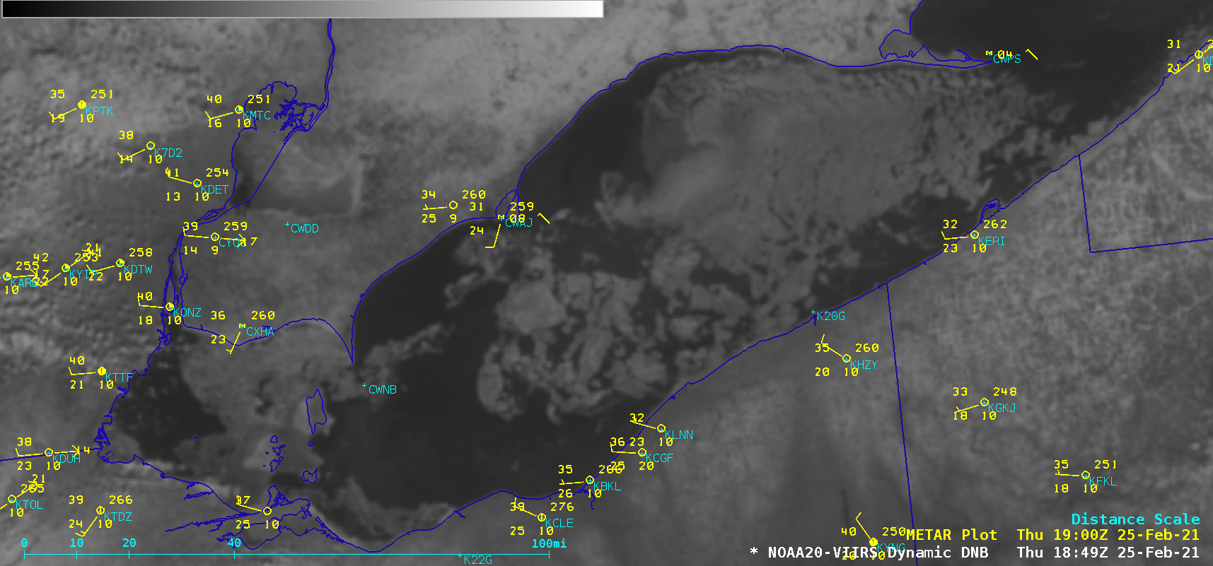
210225_210226_noaa20_viirs_dayNightBand_Lake_Erie_ice_anim.gif
2021-02-26 14:54
739K
noaa20_viirs_dayNightBand_Lake_Erie_ice-20210226_070933.png
2021-02-26 14:51
552K
noaa20_viirs_dayNightBand_Lake_Erie_ice-20210225_184950.png
2021-02-26 14:51
458K
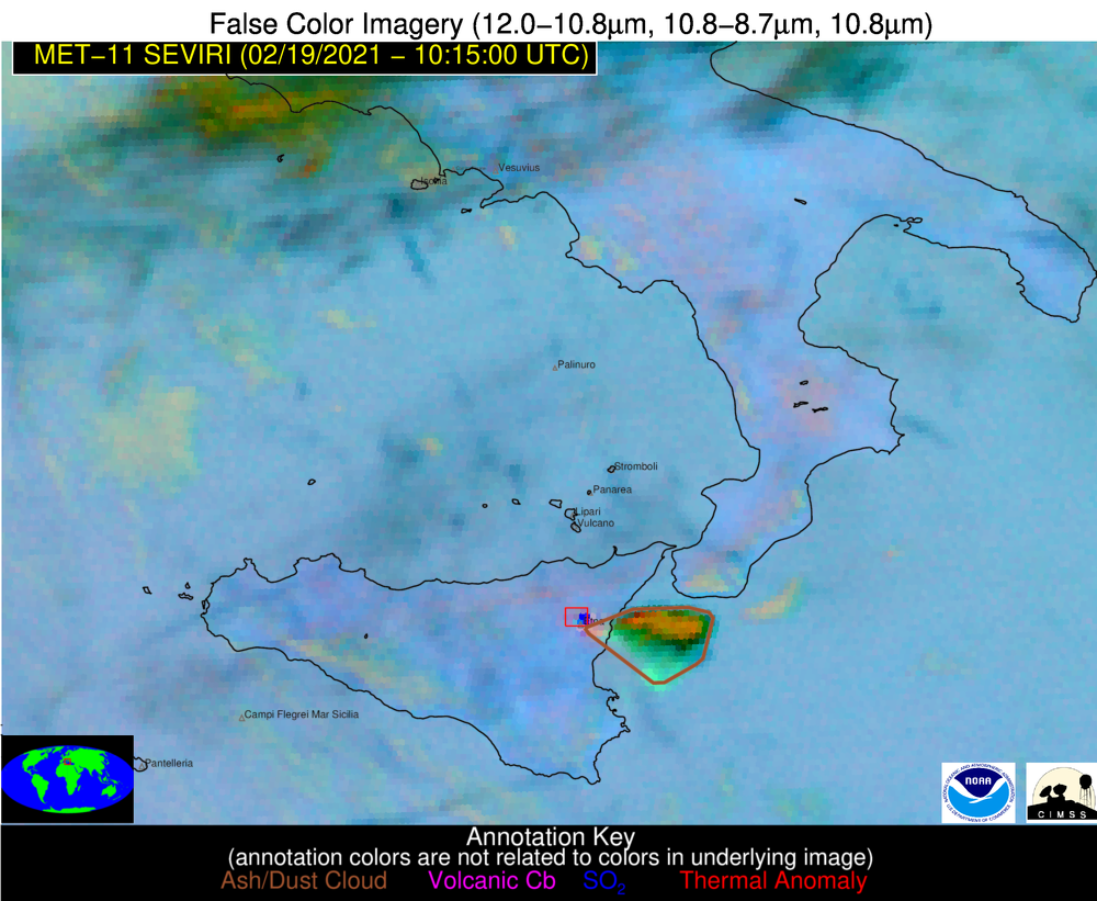
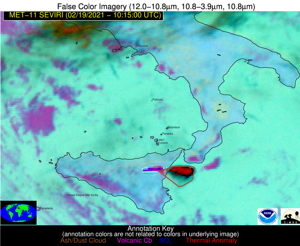
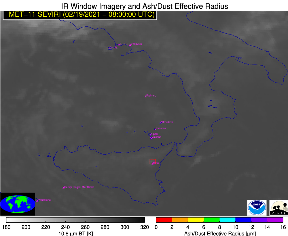
210219_1015utc_so2rgb.png
2021-02-26 02:34
947K
210219_1015utc_rgb.png
2021-02-26 02:34
1.0M
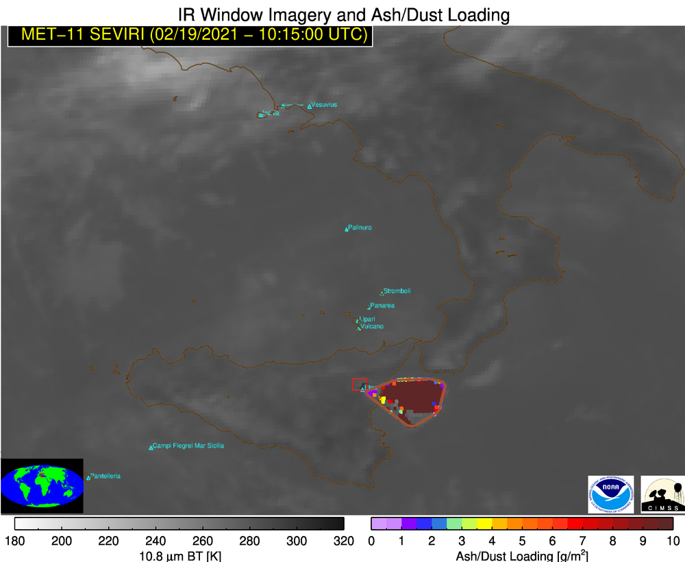
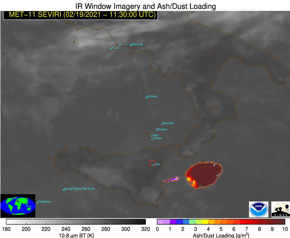
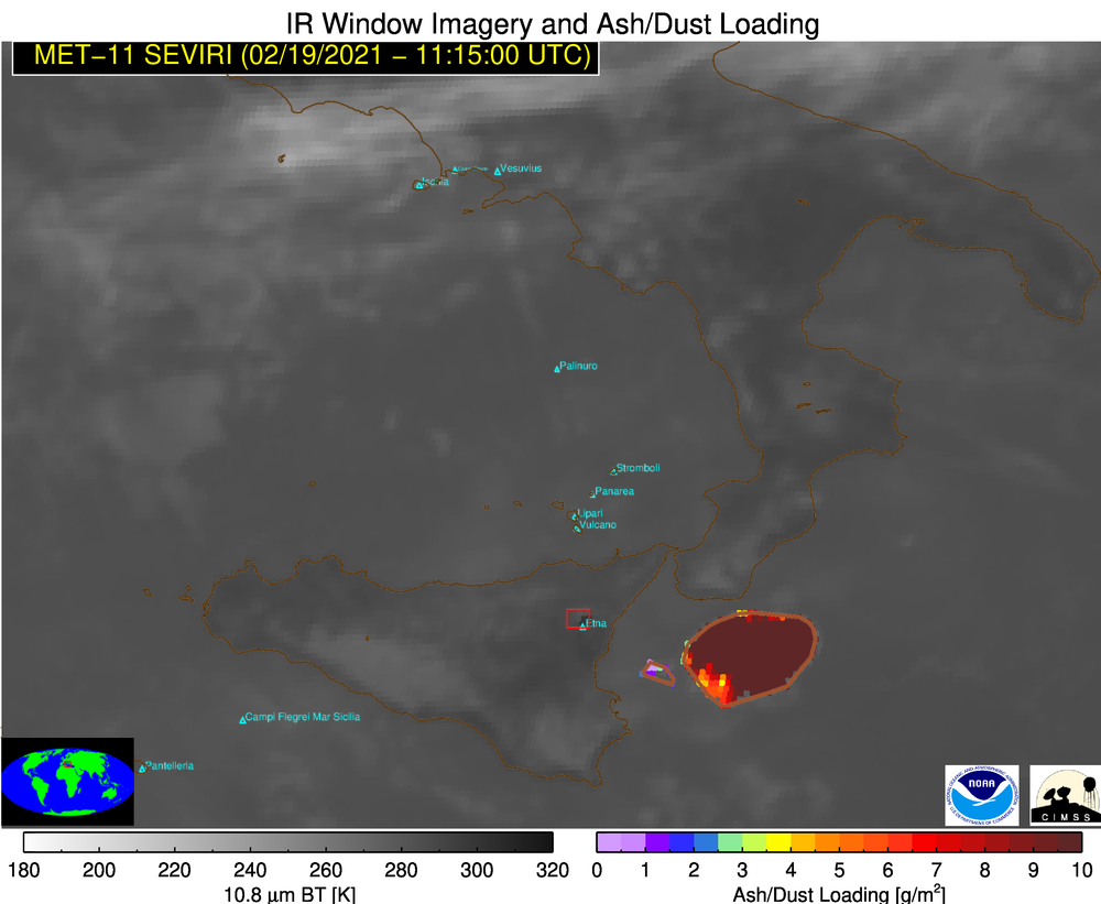
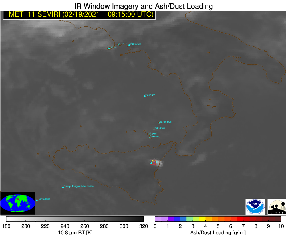
210219_1015utc_Etna_ash_loading.png
2021-02-26 02:34
320K
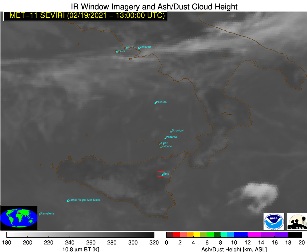
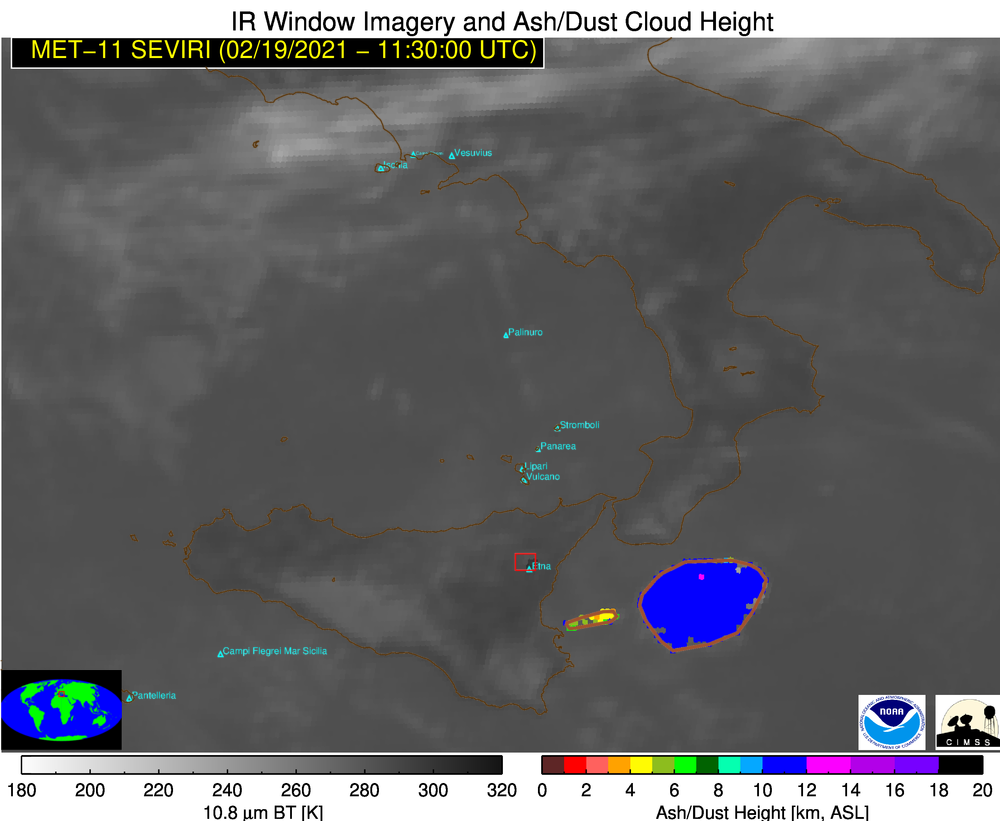
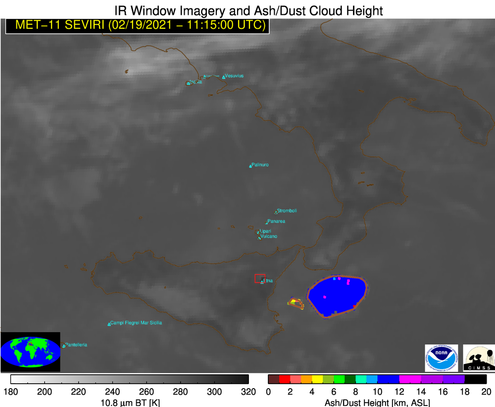
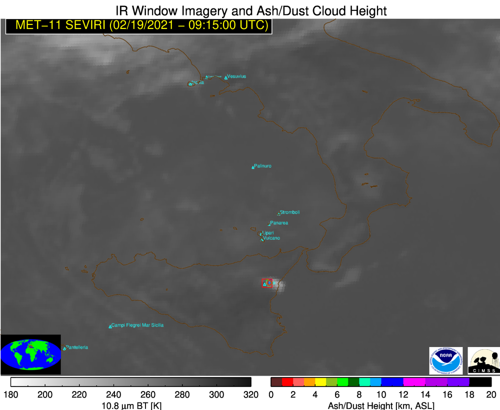
210219_1015utc_Etna_ash_height.png
2021-02-26 02:34
324K
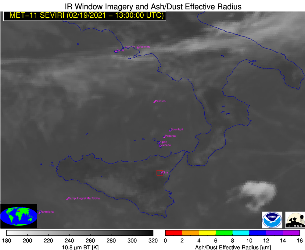
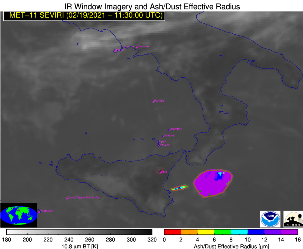
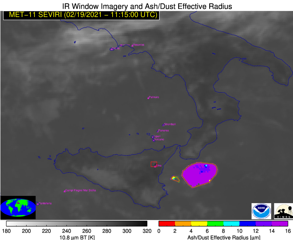
210219_1015utc_Etna_ash_effective_radius.png
2021-02-26 02:34
333K
210219_Etna_so2rgb_anim.mp4
2021-02-26 02:28
1.6M
210219_Etna_so2rgb_anim.gif
2021-02-26 02:28
12M
210219_Etna_rgb_anim.mp4
2021-02-26 02:28
1.9M
210219_Etna_rgb_anim.gif
2021-02-26 02:28
12M
210219_Etna_ash_loading_anim.mp4
2021-02-26 02:28
840K
210219_Etna_ash_loading_anim.gif
2021-02-26 02:28
4.5M
210219_Etna_ash_height_anim.mp4
2021-02-26 02:28
839K
210219_Etna_ash_height_anim.gif
2021-02-26 02:28
4.8M
210219_Etna_ash_effective_radius_anim.mp4
2021-02-26 02:28
844K
210219_Etna_ash_effective_radius_anim.gif
2021-02-26 02:28
4.2M
210219_1400utc_Etna_ash_loading.png
2021-02-26 02:08
341K
210219_1400utc_Etna_ash_height.png
2021-02-26 02:08
343K
210219_1400utc_Etna_ash_effective_radius.png
2021-02-26 02:08
348K
210219_1330utc_Etna_ash_loading.png
2021-02-26 02:08
346K
210219_1330utc_Etna_ash_height.png
2021-02-26 02:08
347K
210219_1330utc_Etna_ash_effective_radius.png
2021-02-26 02:08
353K
210219_1315utc_Etna_ash_loading.png
2021-02-26 02:08
347K
210219_1315utc_Etna_ash_height.png
2021-02-26 02:08
349K
210219_1315utc_Etna_ash_effective_radius.png
2021-02-26 02:08
354K
210219_1300utc_Etna_ash_loading.png
2021-02-26 02:08
348K
210219_1300utc_Etna_ash_height.png
2021-02-26 02:08
350K
210219_1300utc_Etna_ash_effective_radius.png
2021-02-26 02:08
356K
210219_1130utc_Etna_ash_loading.png
2021-02-26 02:08
341K
210219_1130utc_Etna_ash_height.png
2021-02-26 02:08
341K
210219_1130utc_Etna_ash_effective_radius.png
2021-02-26 02:08
349K
210219_1115utc_Etna_ash_loading.png
2021-02-26 02:08
337K
210219_1115utc_Etna_ash_height.png
2021-02-26 02:08
338K
210219_1115utc_Etna_ash_effective_radius.png
2021-02-26 02:08
344K
210219_1100utc_Etna_ash_loading.png
2021-02-26 02:08
340K
210219_1100utc_Etna_ash_height.png
2021-02-26 02:08
343K
210219_1100utc_Etna_ash_effective_radius.png
2021-02-26 02:08
349K
210219_1030utc_Etna_ash_loading.png
2021-02-26 02:08
329K
210219_1030utc_Etna_ash_height.png
2021-02-26 02:08
331K
210219_1030utc_Etna_ash_effective_radius.png
2021-02-26 02:08
338K
210219_1000utc_Etna_ash_loading.png
2021-02-26 02:08
315K
210219_1000utc_Etna_ash_height.png
2021-02-26 02:08
319K
210219_1000utc_Etna_ash_effective_radius.png
2021-02-26 02:08
326K
210219_0930utc_Etna_ash_loading.png
2021-02-26 02:08
309K
210219_0930utc_Etna_ash_height.png
2021-02-26 02:08
311K
210219_0930utc_Etna_ash_effective_radius.png
2021-02-26 02:08
317K
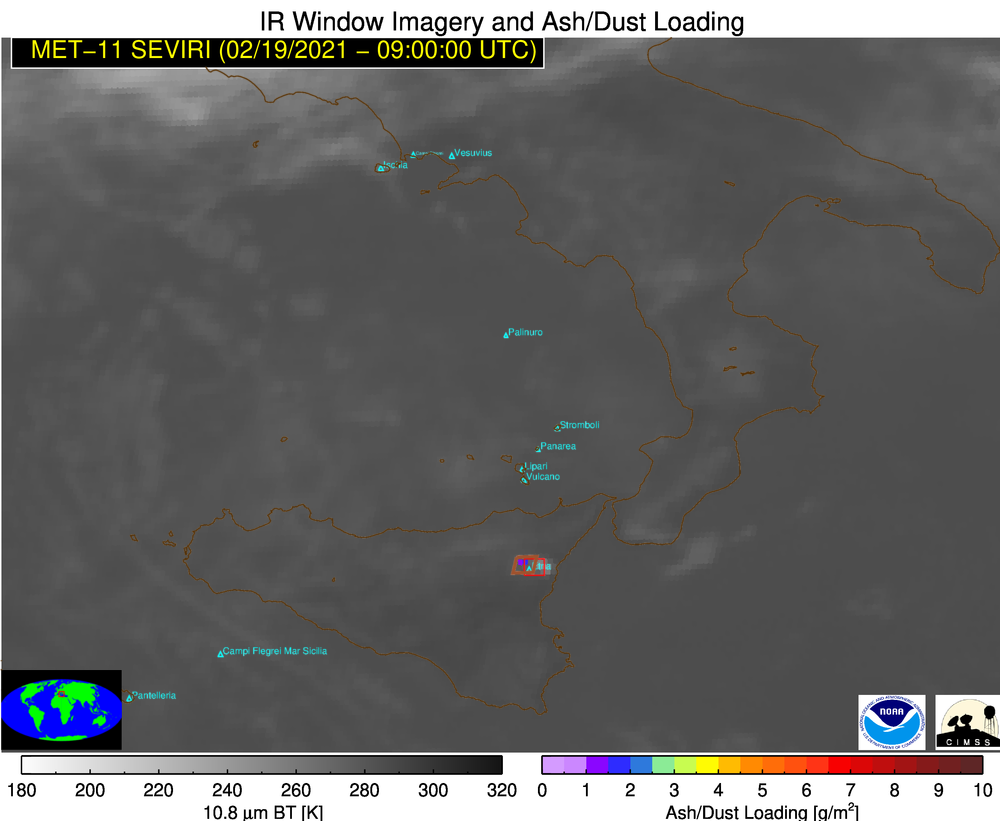
210219_0915utc_Etna_ash_loading.png
2021-02-26 02:08
305K
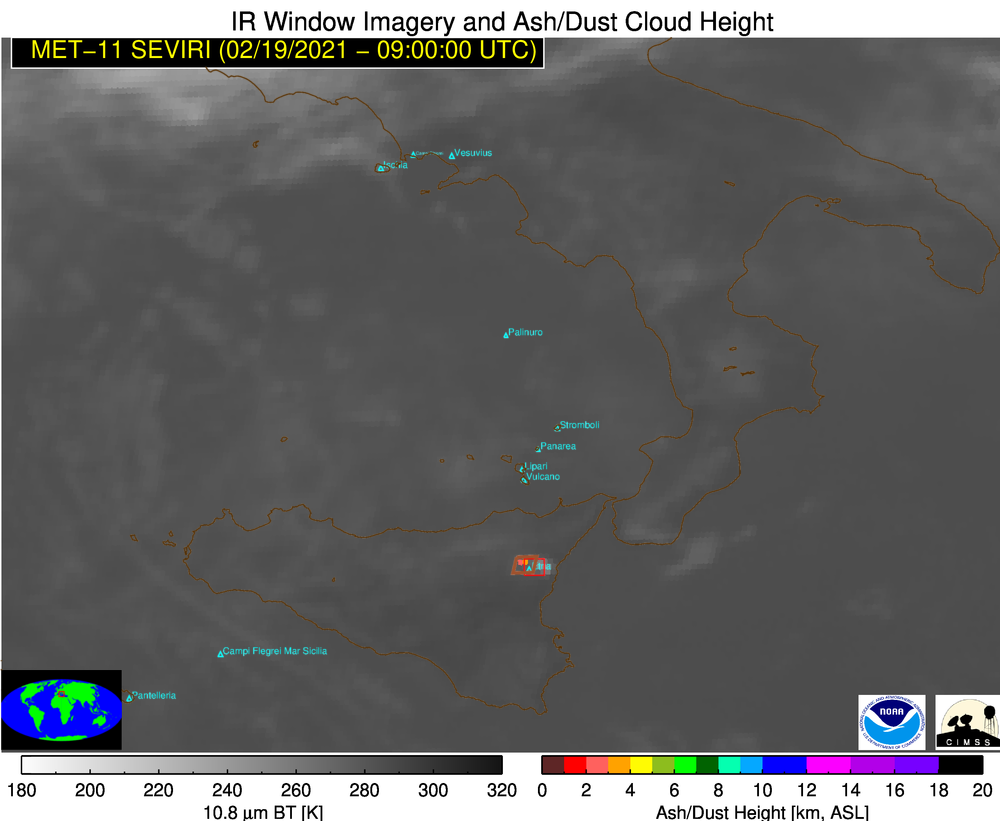
210219_0915utc_Etna_ash_height.png
2021-02-26 02:08
307K
210219_0915utc_Etna_ash_effective_radius.png
2021-02-26 02:08
309K
210219_0900utc_Etna_ash_loading.png
2021-02-26 02:08
302K
210219_0900utc_Etna_ash_height.png
2021-02-26 02:08
303K
210219_0900utc_Etna_ash_effective_radius.png
2021-02-26 02:08
306K
210219_0830utc_Etna_ash_loading.png
2021-02-26 02:08
292K
210219_0830utc_Etna_ash_height.png
2021-02-26 02:08
294K
210219_0830utc_Etna_ash_effective_radius.png
2021-02-26 02:08
301K
210219_0815utc_Etna_ash_loading.png
2021-02-26 02:08
290K
210219_0815utc_Etna_ash_height.png
2021-02-26 02:08
292K
210219_0815utc_Etna_ash_effective_radius.png
2021-02-26 02:08
298K
210219_0800utc_Etna_ash_loading.png
2021-02-26 02:08
288K
210219_0800utc_Etna_ash_height.png
2021-02-26 02:08
289K
210219_0800utc_Etna_ash_effective_radius.png
2021-02-26 02:08
296K
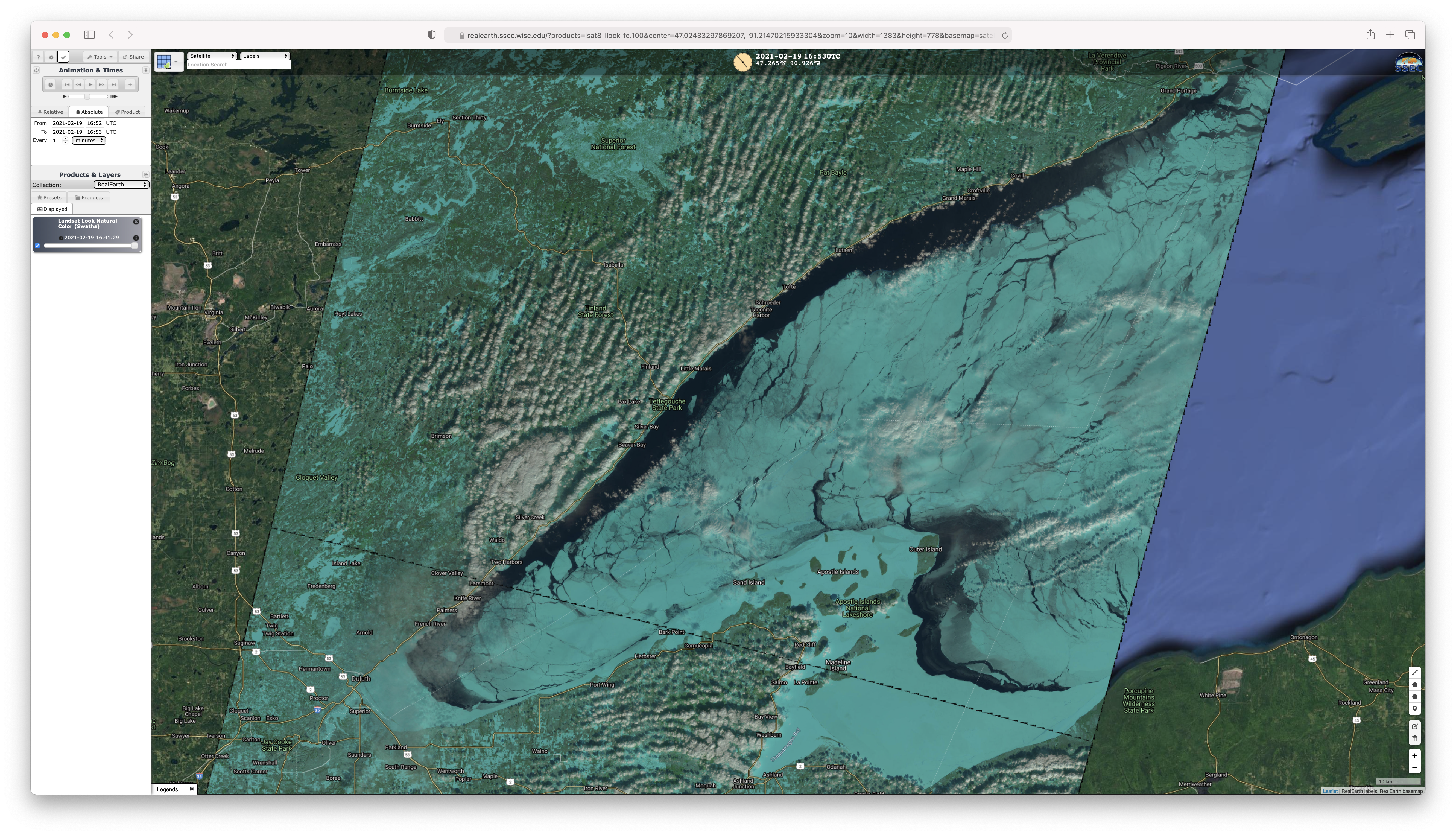
210219_1653utc_landsat8_falseColorRGB_Lake_Superior_ice.png
2021-02-25 21:33
20M
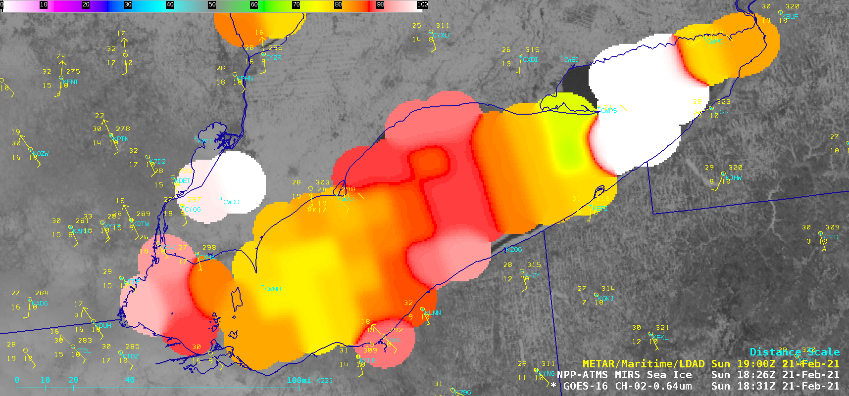
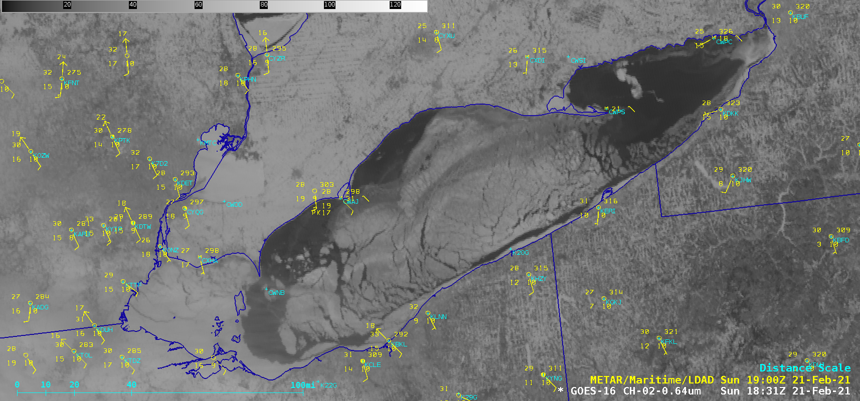
erie_ice_mirs-20210221_183101.png
2021-02-25 02:57
531K
erie_ice-20210221_183101.png
2021-02-25 02:57
663K
chi_ice-20210220_210039.png
2021-02-25 02:54
215K
dlh_ice_mirs-20210219_191102.png
2021-02-25 02:51
203K
dlh_ice-20210219_191102.png
2021-02-25 02:51
335K
lm_ice-20210219_180139.png
2021-02-25 02:49
206K
210222_nstu_lsr.text
2021-02-25 01:23
3.1K
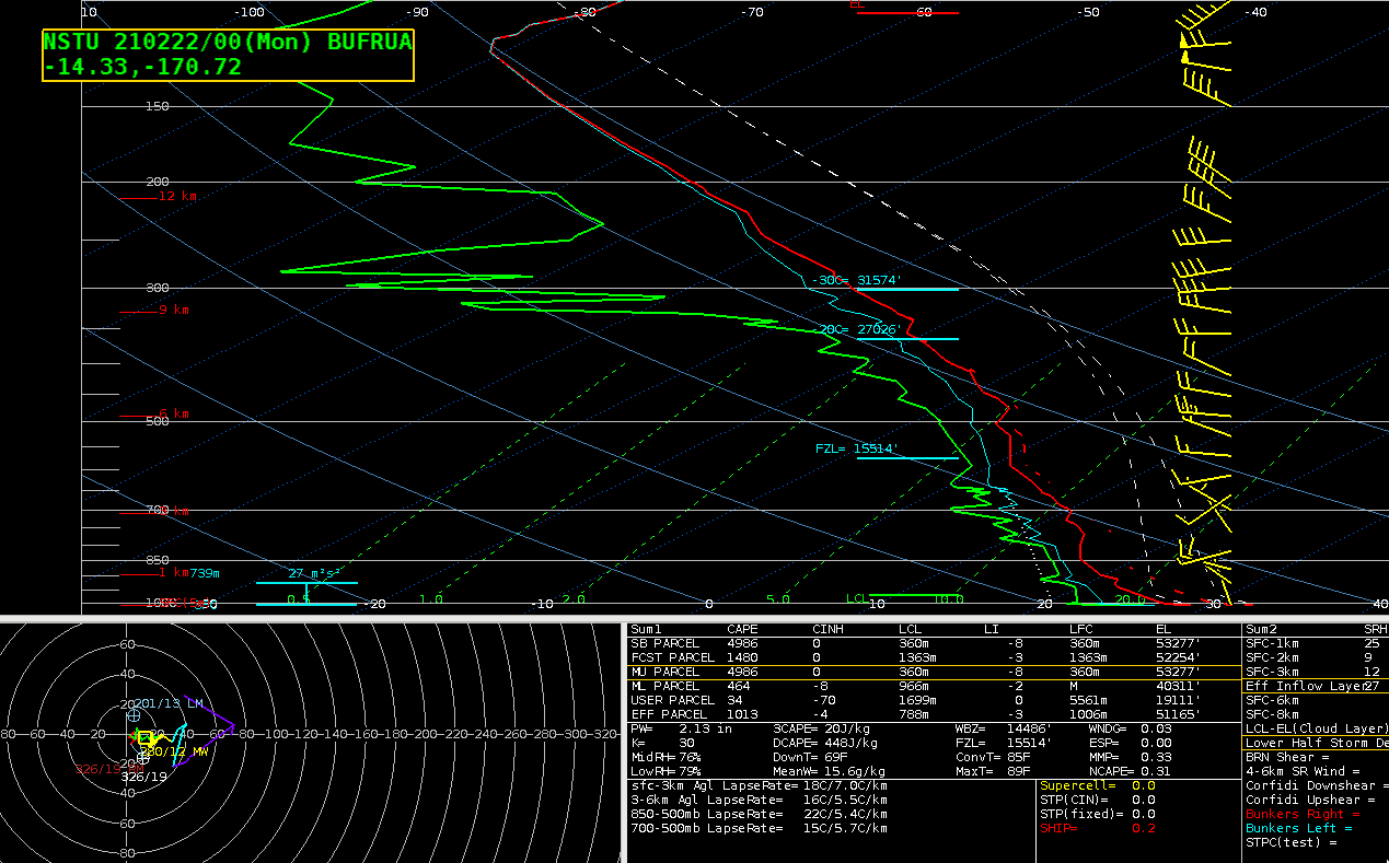
210222_00utc_nstu_raob.png
2021-02-24 22:32
58K
210223_goes17_visible_Invest94P_American_Samoa_anim.mp4
2021-02-24 20:33
6.4M
210223_goes17_visible_Invest94P_American_Samoa_anim.gif
2021-02-24 20:33
143M
210223_21z_sfc_as.jpg
2021-02-24 20:33
343K
210223_18z_sfc_as.jpg
2021-02-24 20:33
337K
210223_18utc_21utc_TD10F_surface_analysis_anim.gif
2021-02-24 20:33
647K
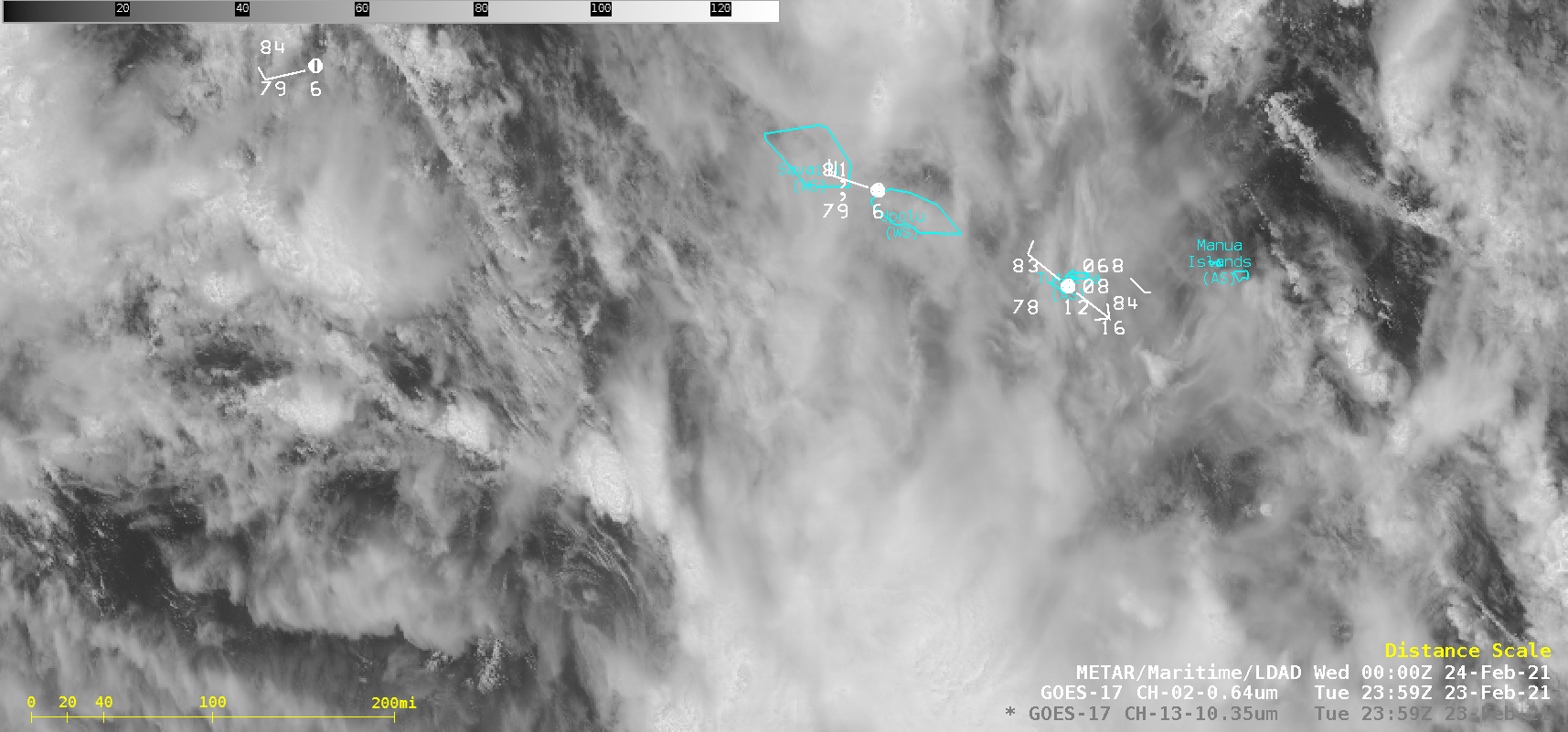
as3_vis-20210223_235949.png
2021-02-24 20:15
417K
210221_nstu_afd.text
2021-02-24 02:38
2.5K
as_ir-20210221_195425.png
2021-02-23 22:35
241K
as2_ir-20210222_195455.png
2021-02-23 22:35
255K
as_ir-20210221_190025.png
2021-02-23 22:34
245K
as2_ir-20210222_190059.png
2021-02-23 22:34
263K
210221_goes17_infrared_Invest94P_American_Samoa_anim.mp4
2021-02-23 22:21
56M
210221_goes17_infrared_Invest94P_American_Samoa_anim.gif
2021-02-23 22:21
346M
as_ir-20210222_040025.png
2021-02-23 22:01
239K
210222_goes17_infrared_Invest94P_TD10F_American_Samoa_anim.mp4
2021-02-23 21:52
87M
210222_goes17_infrared_Invest94P_TD10F_American_Samoa_anim.gif
2021-02-23 21:52
555M
210221_210223_NSTU_raobs_anim.gif
2021-02-23 18:51
197K
210223_NSTU_RAOBS.GIF
2021-02-23 18:47
49K
210222_NSTU_SFCMG.GIF
2021-02-23 18:47
21K
210222_NSTU_RAOBS.GIF
2021-02-23 18:47
50K
210221_NSTU_RAOBS.GIF
2021-02-23 18:47
51K
210222_sst_metar_Invest94P.gif
2021-02-23 18:33
27K
210222_mimicTPW_Invest94P_anim.gif
2021-02-23 18:33
9.5M
210222_16utc_mimicTPW_Invest91P.gif
2021-02-23 18:33
85K
210222_16utc_metar_Invest94P.gif
2021-02-23 18:33
40K
210222_1530utc_infrared_winds_divergence_Invest94P_anim.gif
2021-02-23 18:33
2.3M
210222_1530utc_infrared_winds_convergence_Invest94P_anim.gif
2021-02-23 18:33
2.2M
210222_1530utc_infrared_Invest94P_anim.gif
2021-02-23 18:33
2.1M
210222_1530utc_infrared_ascat_Invest94P_anim.gif
2021-02-23 18:33
2.2M
210221_210222_surface_analyses_Fiji_anim.gif
2021-02-23 03:27
1.9M
210223_0030utc_goes17_infrared_shear_Invest94P_anim2.gif
2021-02-23 02:49
4.0M
210223_0030utc_goes17_infrared_divergence_Invest94P_anim2.gif
2021-02-23 02:48
4.1M
210223_0030utc_goes17_infrared_ascat_Invest94P_anim2.gif
2021-02-23 02:48
4.2M
210223_0030utc_goes17_infrared_shear_Invest94P_anim.gif
2021-02-23 02:46
2.1M
210223_0030utc_goes17_infrared_Invest94P_anim.gif
2021-02-23 02:46
2.0M
210223_0030utc_goes17_infrared_divergence_Invest94P_anim.gif
2021-02-23 02:46
2.2M
210223_0030utc_goes17_infrared_ascat_Invest94P_anim.gif
2021-02-23 02:46
2.2M
210222_21z_sfc_as.jpg
2021-02-23 02:46
305K
210222_18z_sfc_as.jpg
2021-02-23 02:46
303K
210222_06z_sfc_as.jpg
2021-02-23 02:46
345K
210222_03z_sfc_as.jpg
2021-02-23 02:46
222K
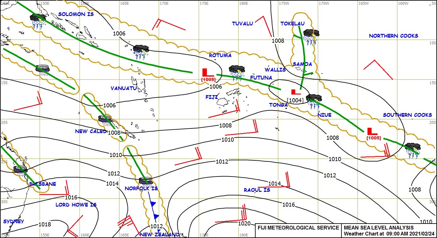
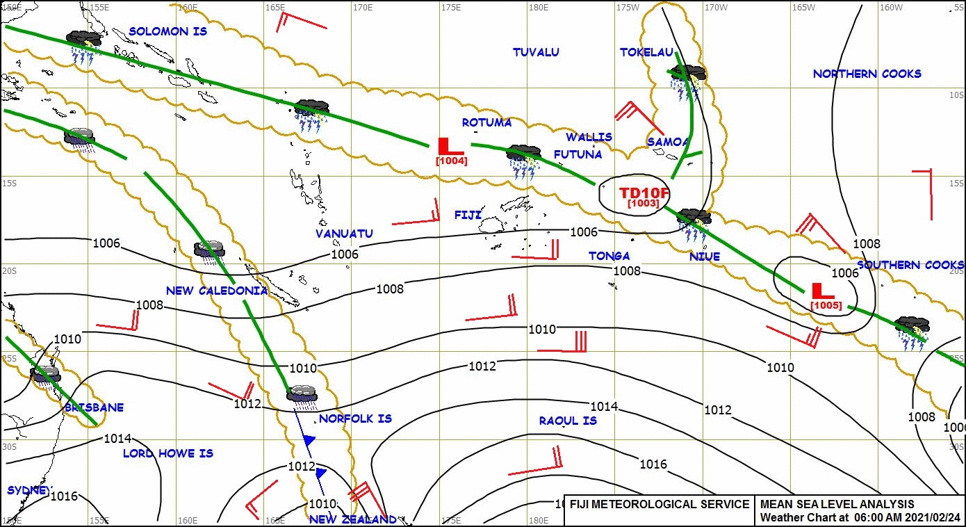
210222_00z_sfc_as.jpg
2021-02-23 02:46
222K
210222_0030z_sfc_as.jpg
2021-02-23 02:46
215K
210221_21z_sfc_as.jpg
2021-02-23 02:46
295K
210221_18z_sfc_as.jpg
2021-02-23 02:46
308K
210221_15z_sfc_as.jpg
2021-02-23 02:46
210K
210221_06z_sfc_as.jpg
2021-02-23 02:46
223K
210221_03z_sfc_as.jpg
2021-02-23 02:46
318K
210221_00z_sfc_as.jpg
2021-02-23 02:46
274K
210222_NSFA_SFCMG.GIF
2021-02-22 21:35
19K
210222_NLWW_SFCMG.GIF
2021-02-22 21:35
19K
210221_goes17_infrared_American_Samoa_anim.mp4
2021-02-22 18:57
79M
210221_goes17_infrared_American_Samoa_anim.gif
2021-02-22 18:57
507M
210221_210222_goes17_infrared_American_Samoa_anim.mp4
2021-02-22 18:57
135M
210221_210222_goes17_infrared_American_Samoa_anim.gif
2021-02-22 18:57
849M
as_ir-20210221_235525.png
2021-02-22 04:24
237K
210221_surface_analyses_Fiji_anim.gif
2021-02-22 04:19
2.0M
210221_1831utc_goes16_visible_suomiNPPmirs_ice_concentration_Lake_Erie_anim.gif
2021-02-22 01:08
838K
210221_goes16_visible_Lake_Erie_ice_anim.mp4
2021-02-21 23:43
2.1M
210221_goes16_visible_Lake_Erie_ice_anim.gif
2021-02-21 23:43
40M
210220_goes16_visible_Lake_Michigan_ice_anim.mp4
2021-02-21 00:18
3.4M
210220_goes16_visible_Lake_Michigan_ice_anim.gif
2021-02-21 00:18
167M
210219_goes16_visible_Lake_Superior_ice_anim.mp4
2021-02-20 20:45
2.1M
210219_goes16_visible_Lake_Superior_ice_anim.gif
2021-02-20 20:45
27M
210219_goes16_visible_Lake_Michigan_ice_anim.mp4
2021-02-19 23:49
3.7M
210219_goes16_visible_Lake_Michigan_ice_anim.gif
2021-02-19 23:49
180M
210217_210218_surface_analyses_East_Pacific_anim.gif
2021-02-19 04:07
1.1M
210218_12z_epac.png
2021-02-19 04:05
546K
210218_06z_epac.png
2021-02-19 04:05
534K
210218_00z_epac.png
2021-02-19 04:05
554K
210217_18z_epac.png
2021-02-19 04:05
540K
210217_210218_goes17_goes15_waterVapor_EastPacifc_anim.mp4
2021-02-19 01:31
9.1M
210217_210218_goes17_goes15_waterVapor_EastPacifc_anim.gif
2021-02-19 01:31
44M
G17_G15_WV_EPAC_17FEB2021_B93_2021048_232031_0002PANELS_FRAME0000039.GIF
2021-02-19 01:31
439K
GOES-15_loop_2021048_000000_2021049_141500_07sec.mp4
2021-02-18 14:45
4.6M
GOES-15_loop_2021048_000000_2021049_141500_14sec.mp4
2021-02-18 14:43
7.7M
COLD_B13_loop_1k_2021036_140013_2021049_130006_21sec.mp4
2021-02-18 13:40
32M
COLD_B13_loop_1k_2021036_140013_2021049_130006.mp4
2021-02-18 13:28
13M
tehuano_topo-20210216_151007.png
2021-02-18 03:34
787K
210216_1512utc_metopA_ascat.png
2021-02-18 03:17
29K
210214_210217_viirs_dayNightBand_OK_TX_anim.gif
2021-02-18 00:41
3.0M
210215_KAMA_OBS.TEXT
2021-02-17 23:24
1.2K
210215_KBRO_OBS.TEXT
2021-02-17 23:23
1.8K
210215_1721utc_landsat8_falseColorRGB_KAMA_plume_anim.gif
2021-02-17 22:00
2.0M
210215_landsat8_overpass_times.gif
2021-02-17 21:54
112K
210215_1721utc_landsat8_falseColorRGB_KAMA_plume.png
2021-02-17 21:54
1.7M
210215_1721utc_landsat8_falseColorRGB_KAMA_plume_metar.png
2021-02-17 21:54
1.6M
210215_1706utc_landsat8_falseColorRGB_KAMA_plume.png
2021-02-17 21:54
1.7M
GOES-17_ABI_RadF_true_color_2021047_140032Z.png
2021-02-17 19:12
5.3M
210216_goes17_trueColorRGB_Tehuano_anim.mp4
2021-02-17 17:15
9.0M
210216_goes17_trueColorRGB_Tehuano_anim.gif
2021-02-17 17:15
62M
GOES-17_ABI_RadF_true_color_2021047_130032Z.png
2021-02-17 16:39
4.5M
COLD_B13_loop_1k_2021036_140013_2021048_130006.mp4
2021-02-17 15:33
14M
COLD_B13_loop_1000x1000_2021036_140013_2021048_130006.mp4
2021-02-17 15:19
21M
COLD_B13_loop_2021036_000013_2021048_130008.mp4
2021-02-17 14:10
12M
kama_plume-20210215_170104.png
2021-02-17 03:26
157K
tehuano-20210216_151007.png
2021-02-17 02:07
301K
210216_goes16_cimssNaturalColorRGB_ascat_Tehuano_anim.mp4
2021-02-17 02:05
2.7M
210216_goes16_cimssNaturalColorRGB_ascat_Tehuano_anim.gif
2021-02-17 02:05
34M
210216_1623utc_landsat8_falsecolorRGB_Straits_of_Mackinac.png
2021-02-17 01:06
1.2M
tx_nir_obs-20210215_220104.png
2021-02-16 22:25
793K
tx_nir-20210215_220104.png
2021-02-16 22:25
781K
210215_goes16_nearInfraredSnowIce_TX_anim.mp4
2021-02-16 22:15
11M
210215_goes16_nearInfraredSnowIce_TX_anim.gif
2021-02-16 22:15
79M
210215_goes16_nearInfraredSnowIce_KAMA_plume_anim.mp4
2021-02-16 22:15
1.4M
210215_goes16_nearInfraredSnowIce_KAMA_plume_anim.gif
2021-02-16 22:15
16M
210215_goes16_dayCloudPhaseDistinctionRGB_TX_snow_cover_anim.mp4
2021-02-16 22:15
6.1M
210215_goes16_dayCloudPhaseDistinctionRGB_TX_snow_cover_anim.gif
2021-02-16 22:15
69M
210215_goes16_dayCloudPhaseDistinctionRGB_OK_TX_snow_cover_anim.mp4
2021-02-16 22:15
8.9M
210215_goes16_dayCloudPhaseDistinctionRGB_OK_TX_snow_cover_anim.gif
2021-02-16 22:15
68M
210215_goes16_infrared_spcStormReports_NC_tornado_anim.mp4
2021-02-16 21:07
2.8M
210215_goes16_infrared_spcStormReports_NC_tornado_anim.gif
2021-02-16 21:07
13M
G16_IR_NC_SVR_15FEB2021_B13_2021047_041111_GOES-16_0001PANEL_FRAME0000001.GIF
2021-02-16 19:30
177K
lsup_vis-20210215_200104.png
2021-02-16 16:26
906K
dlh_ice-20210215_200104.png
2021-02-16 16:26
267K
lsup_vis-20210215_210104.png
2021-02-16 16:24
873K
dlh_ice-20210215_210104.png
2021-02-16 16:24
260K
lsup_vis-20210215_220104.png
2021-02-16 16:22
799K
dlh_ice-20210215_220104.png
2021-02-16 16:22
244K
lsup_vis_ascat-20210215_152604.png
2021-02-16 16:20
880K
tx_snow_lg-20210215_180104.png
2021-02-16 16:19
3.1M
tx_snow-20210215_180104.png
2021-02-16 16:19
2.5M
COLD_B13_loop_2021036_000013_2021047_130008.mp4
2021-02-16 14:47
13M
210215_goes16_visible_Lake_Superior_ice_anm.mp4
2021-02-16 03:13
2.7M
210215_goes16_visible_Lake_Superior_ice_anm.gif
2021-02-16 03:13
38M
210215_goes16_visible_Lake_Superior_anim.mp4
2021-02-16 03:13
4.5M
210215_goes16_visible_Lake_Superior_anim.gif
2021-02-16 03:13
54M
COLD_B13_loop_2021036_000013_2021046_130008.mp4
2021-02-15 14:22
13M
210212_1800utc_visible_dayCloudPhaseDiscriminationRGB_Lake_Michigan_mesovortex_anim.gif
2021-02-15 02:55
1.1M
210212_goes16_visible_dayCloudPhaseDiscrminationRGB_Lake_Michigan_mesovortex_anim.mp4
2021-02-15 02:24
11M
210212_goes16_visible_dayCloudPhaseDiscrminationRGB_Lake_Michigan_mesovortex_anim.gif
2021-02-15 02:24
371M
mt_ir-20210213_140105.png
2021-02-15 01:35
312K
mt_ct-20210213_140105.png
2021-02-15 01:35
96K
210212_goes16_dayCloudPhaseDiscrminationRGB_Lake_Michigan_mesovortex_anim.mp4
2021-02-15 01:32
6.9M
210212_goes16_dayCloudPhaseDiscrminationRGB_Lake_Michigan_mesovortex_anim.gif
2021-02-15 01:32
275M
lm_vis2-20210212_190043.png
2021-02-15 01:27
253K
lm_vis-20210212_190043.png
2021-02-15 01:27
216K
lm_rgb-20210212_190043.png
2021-02-15 01:27
342K
lm_vis2-20210212_180043.png
2021-02-15 01:27
264K
lm_vis-20210212_180043.png
2021-02-15 01:27
221K
lm_rgb-20210212_180043.png
2021-02-15 01:27
351K
lm_vis2-20210212_181943.png
2021-02-15 00:29
256K
lm_vis-20210212_181943.png
2021-02-15 00:29
220K
lm_rgb-20210212_181943.png
2021-02-15 00:29
347K
COLD_B13_loop_2021036_000013_2021045_130008.mp4
2021-02-14 13:46
12M
45_Stabius_Werner_III_merged_Rad_in_OR_ABI-L1b-RadF-M6C14_G17_s20210451200321_.png
2021-02-14 13:18
1.3M
210213_goes17_waterVapor_Alaska_Range_anim.mp4
2021-02-14 03:46
7.5M
210213_goes17_waterVapor_Alaska_Range_anim.gif
2021-02-14 03:46
80M
210213_goes17_waterVapor_Hawaii_anim.mp4
2021-02-14 02:38
7.1M
210213_goes17_waterVapor_Hawaii_anim.gif
2021-02-14 02:38
93M
210213_goes16_infrared_cloudThickness_MT_anim.mp4
2021-02-14 01:29
5.4M
210213_goes16_infrared_cloudThickness_MT_anim.gif
2021-02-14 01:29
30M
210212_goes16_visible_Lake_Michigan_mesovortex_v2_anim.mp4
2021-02-13 18:44
4.1M
210212_goes16_visible_Lake_Michigan_mesovortex_v2_anim.gif
2021-02-13 18:44
96M
210212_goes16_visible_Lake_Michigan_mesovortex_anim.mp4
2021-02-13 18:44
3.4M
210212_goes16_visible_Lake_Michigan_mesovortex_anim.gif
2021-02-13 18:44
76M
45_Stabius_Werner_III_merged_Rad_in_OR_ABI-L1b-RadF-M3C13_G16_s20190431800312_.png
2021-02-13 16:56
1.3M
Stabius_Werner_III_merged_Rad_in_OR_ABI-L1b-RadF-M3C13_G16_s20190431800312_.png
2021-02-13 16:48
1.4M
COLD_B13_loop_2021036_000013_2021044_130008.mp4
2021-02-13 15:24
14M
COLD_B13_loop_2021043_140009_2021044_130008.mp4
2021-02-13 15:09
1.8M
G16ABIBand04_Winds_Turb-20210211_1236_to_20210212_0001anim.mp4
2021-02-12 20:13
14M
COLD_B13_loop_2021036_000013_2021043_130009.mp4
2021-02-12 14:21
13M
COLD_B13_loop_2021036_000013_2021042_130009.mp4
2021-02-11 14:16
10M
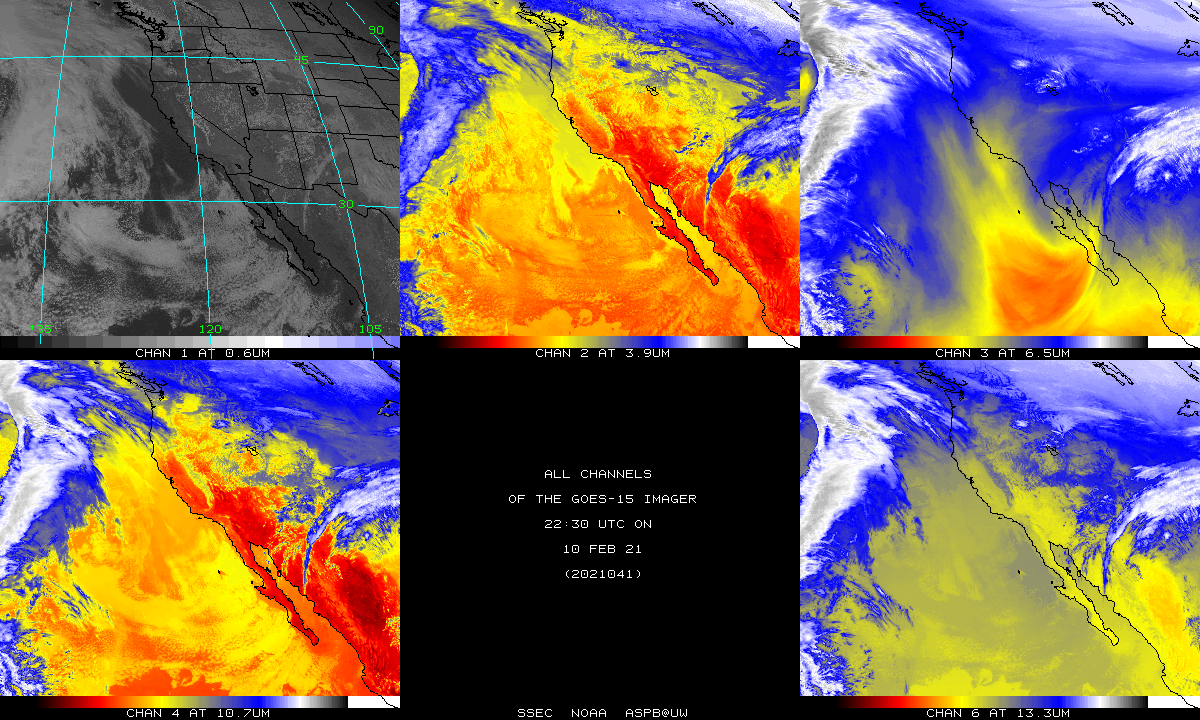
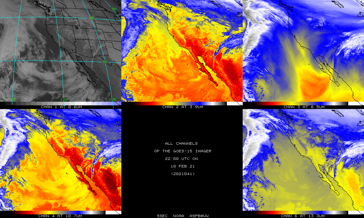
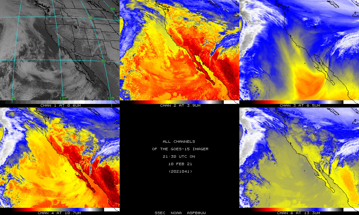
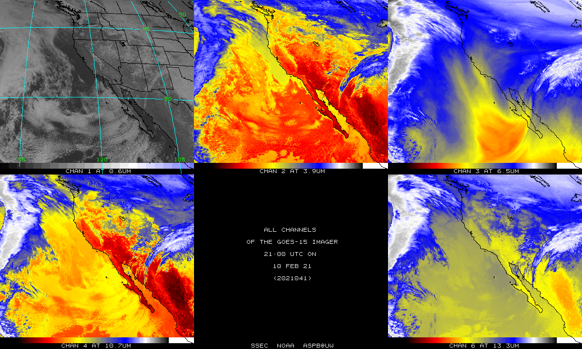
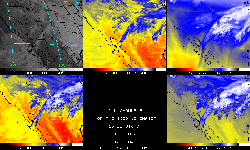
210210_goes15_imager_bands_anim.gif
2021-02-11 00:54
8.2M
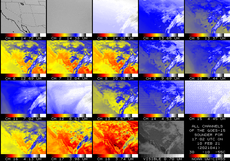
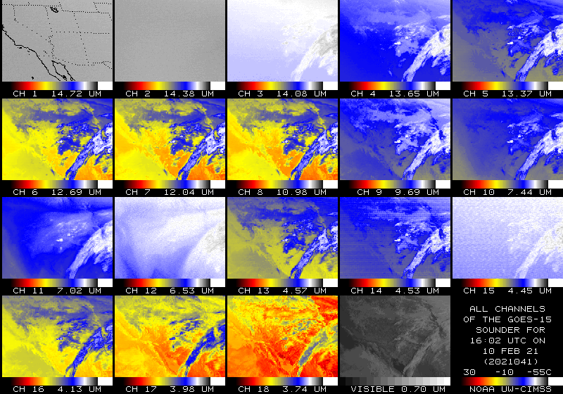
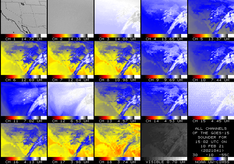
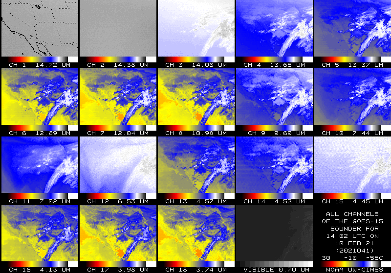
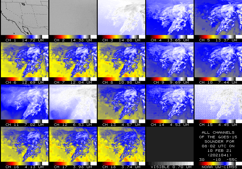
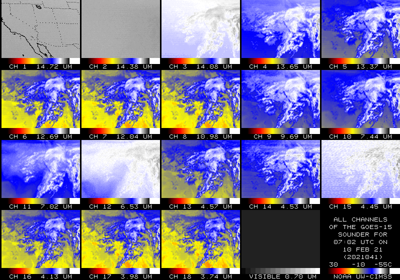
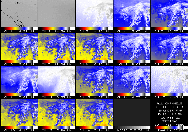
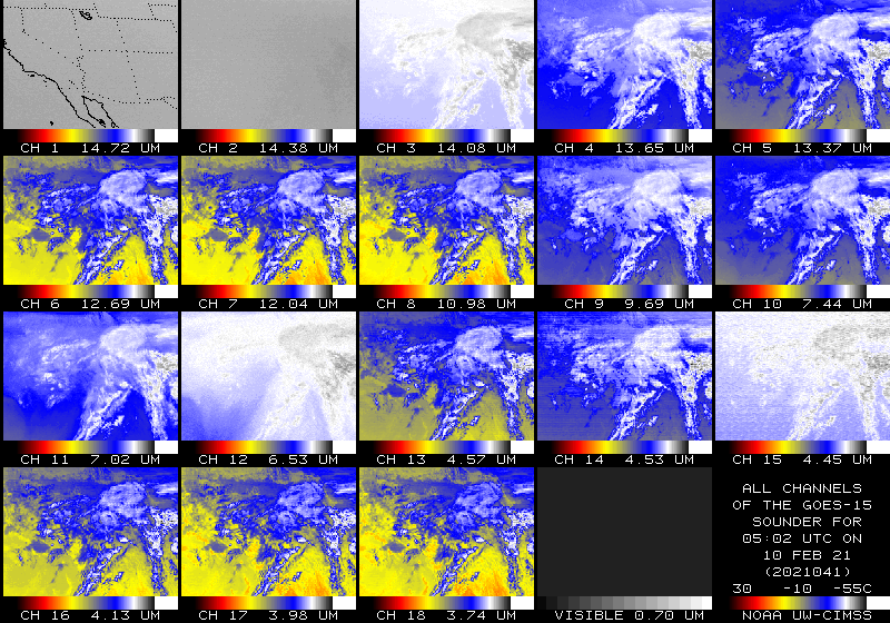
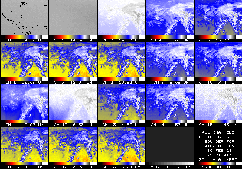
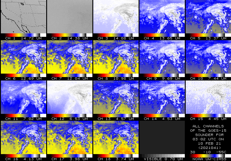
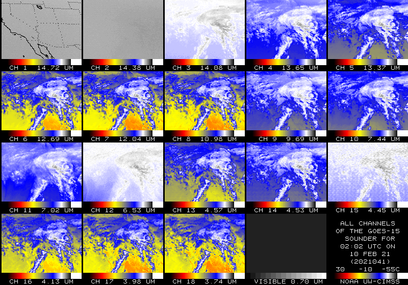
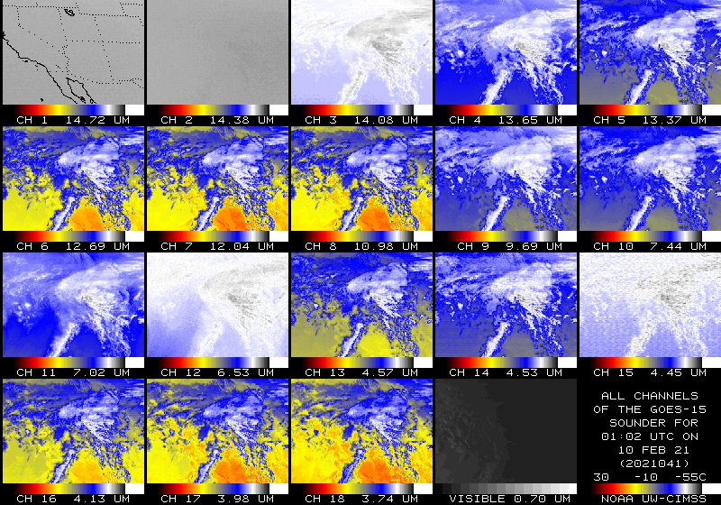
210210_goes15_sounder_bands_anim.gif
2021-02-11 00:50
6.5M
G15_sounder.mp4
2021-02-10 23:46
2.5M
GOES15_6panel.mp4
2021-02-10 23:29
1.6M
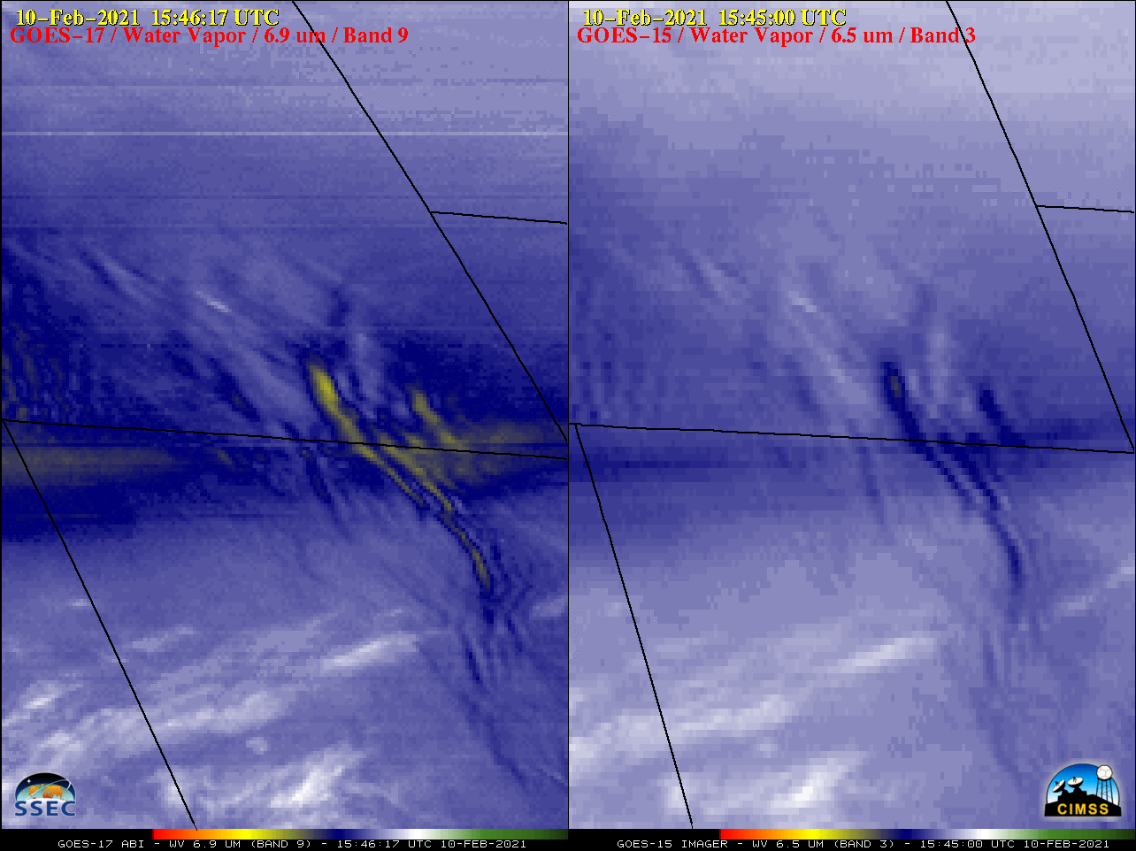
210210_goes17_goes15_waterVapor_WY_mountain_waves_anim.mp4
2021-02-10 23:18
3.3M
210210_goes17_goes15_waterVapor_WY_mountain_waves_anim.gif
2021-02-10 23:18
13M
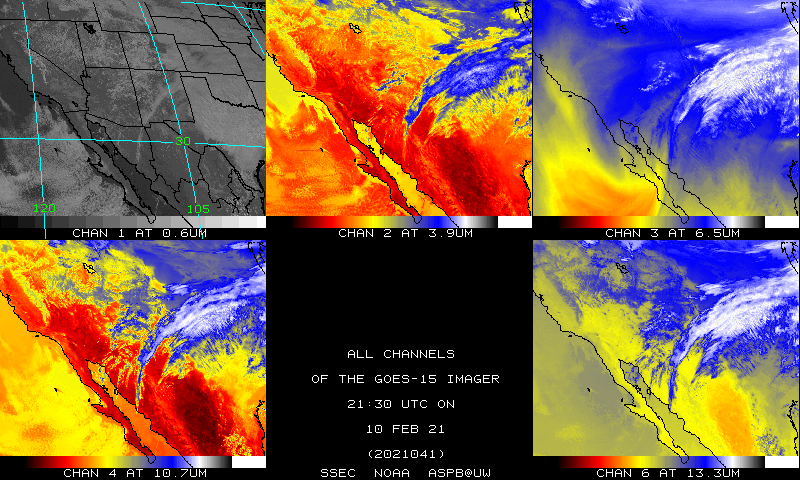
gwall.21041.2200.gif
2021-02-10 23:10
229K
gwall.21041.2100.gif
2021-02-10 23:10
234K
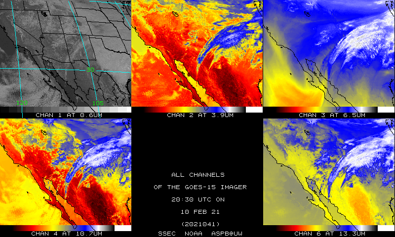
gwall.21041.2000.gif
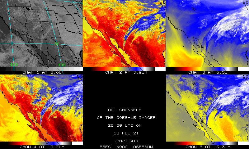
2021-02-10 23:10
236K
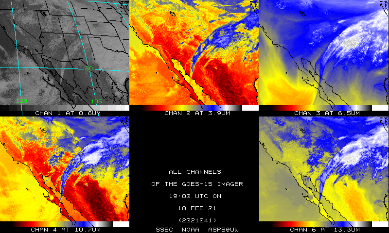
gwall.21041.1900.gif
2021-02-10 23:10
231K
gwall.21041.1800.gif
2021-02-10 23:10
227K
gwall.21041.1700.gif
2021-02-10 23:10
217K
gwall.21041.1600.gif
2021-02-10 23:10
206K
gwall.21041.1500.gif
2021-02-10 23:10
200K
gwall.21041.1400.gif
2021-02-10 23:10
199K
gwall.21041.1300.gif
2021-02-10 23:10
200K
gwall.21041.1200.gif
2021-02-10 23:10
204K
gwall.21041.1100.gif
2021-02-10 23:10
206K
gwall.21041.1000.gif
2021-02-10 23:10
207K
gwall.21041.0900.gif
2021-02-10 23:10
210K
gwall.21041.0800.gif
2021-02-10 23:10
215K
gwall.21041.0700.gif
2021-02-10 23:10
218K
gwall.21041.0600.gif
2021-02-10 23:10
221K
gwall.21041.0500.gif
2021-02-10 23:10
223K
gwall.21041.0400.gif
2021-02-10 23:10
226K
gwall.21041.0300.gif
2021-02-10 23:10
226K
gwall.21041.0200.gif
2021-02-10 23:10
226K
gwall.21041.0100.gif
2021-02-10 23:10
232K
gwall.21041.0000.gif
2021-02-10 23:10
242K
GIA15_NH_720_13.GIF
2021-02-10 23:03
445K
GIA15_NH_720_12.GIF
2021-02-10 23:03
451K
GIA15_NH_720_11.GIF
2021-02-10 23:03
457K
GIA15_NH_720_10.GIF
2021-02-10 23:03
459K
GIA15_NH_720_09.GIF
2021-02-10 23:03
457K
GIA15_NH_720_08.GIF
2021-02-10 23:03
457K
GIA15_NH_720_07.GIF
2021-02-10 23:03
452K
GIA15_NH_720_06.GIF
2021-02-10 23:03
445K
GIA15_NH_720_05.GIF
2021-02-10 23:03
439K
GIA15_NH_720_04.GIF
2021-02-10 23:03
432K
GIA15_NH_720_03.GIF
2021-02-10 23:02
422K
GIA15_NH_720_02.GIF
2021-02-10 23:02
412K
GIA15_NH_720_01.GIF
2021-02-10 23:01
401K
GIA15_NH_12.GIF
2021-02-10 22:39
205K
GIA15_NH_11.GIF
2021-02-10 22:39
207K
GIA15_NH_10.GIF
2021-02-10 22:39
209K
GIA15_NH_09.GIF
2021-02-10 22:39
210K
GIA15_NH_08.GIF
2021-02-10 22:39
211K
GIA15_NH_07.GIF
2021-02-10 22:39
210K
GIA15_NH_06.GIF
2021-02-10 22:38
208K
GIA15_NH_05.GIF
2021-02-10 22:38
205K
GIA15_NH_04.GIF
2021-02-10 22:38
203K
GIA15_NH_03.GIF
2021-02-10 22:38
199K
GIA15_NH_02.GIF
2021-02-10 22:38
194K
GIA15_NH_01.GIF
2021-02-10 22:37
189K
210210_goes17_goes15_waterVapor_WY_CO_mountain_waves_anim.mp4
2021-02-10 22:22
3.3M
210210_goes17_goes15_waterVapor_WY_CO_mountain_waves_anim.gif
2021-02-10 22:22
13M
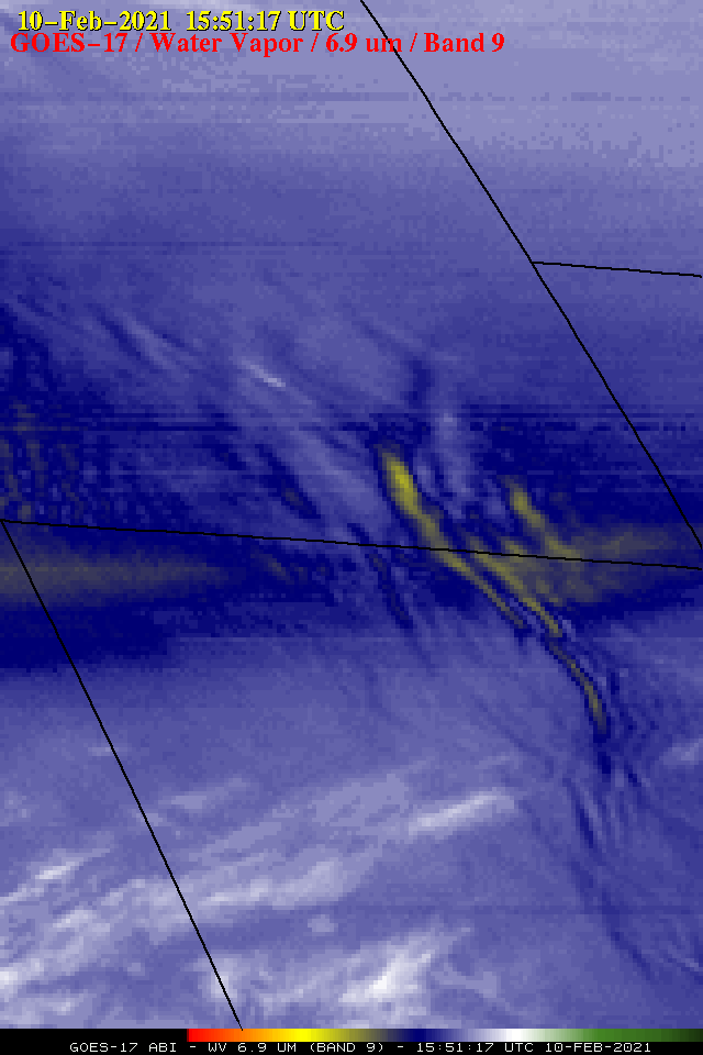
G17_G15_WV_WY_10FEB2021_B93_2021041_154617_0002PANELS_FRAME0000001.GIF
2021-02-10 22:10
185K
G17_G15_WV_WY_10FEB2021_960x640_AGOES17_B0009_2021041_155117_PANEL0001.GIF
2021-02-10 21:59
92K
GOES15_B4_loop_2021040_200000_2021041_201500.mp4
2021-02-10 20:55
4.6M
GOES15_B01_loop_2021041_153000_2021041_201500.mp4
2021-02-10 20:46
712K
B01_GOES15_loop_2021041_153000_2021041_201500.mp4
2021-02-10 20:43
237K
GOES15_B3_loop_2021040_200000_2021041_201500.mp4
2021-02-10 20:42
1.6M
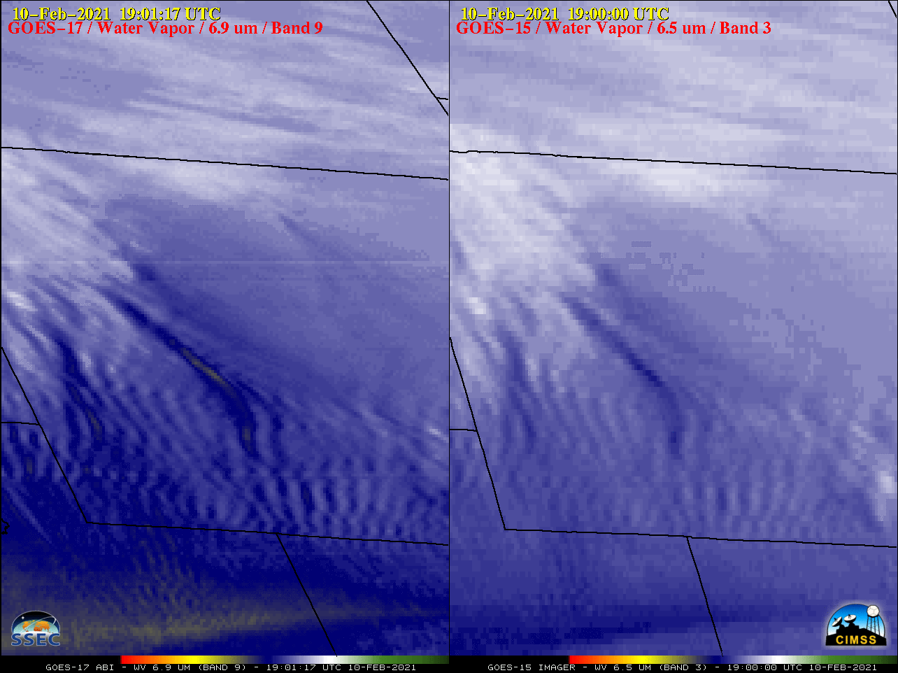
G17_G15_WV_WY_10FEB2021_B93_2021041_190117_0002PANELS_FRAME0000040.GIF
2021-02-10 20:11
181K
COLD_B13_loop_2021036_120013_2021041_133010_hourly.mp4
2021-02-10 14:23
8.4M
210208_goes16_visible_ascat_Lake_Superior_ice_v2_anim.mp4
2021-02-09 16:06
3.1M
210208_goes16_visible_ascat_Lake_Superior_ice_v2_anim.gif
2021-02-09 16:06
50M
210208_goes16_visible_ascat_Lake_Superior_ice_anim.mp4
2021-02-09 16:06
2.1M
210208_goes16_visible_ascat_Lake_Superior_ice_anim.gif
2021-02-09 16:06
37M
COLD_B13_loop_2021036_120013_2021040_120010_hourly.mp4
2021-02-09 14:56
8.1M
COLD_B13_loop_2021036_120013_2021040_125010.mp4
2021-02-09 14:44
15M
lsup_vis_ascat-20210208_142608.png
2021-02-08 23:52
560K
210207_1616utc_landsat8_falseColorRGB_LakeMichigan_ice.png
2021-02-08 23:04
3.2M
G16VISDuluthSuperior-20210208_1431_to_1836anim.mp4
2021-02-08 22:13
2.6M
210207_19utc_sst_glerl.gif
2021-02-08 20:47
37K
210207_19utc_ice_thickness_glerl.gif
2021-02-08 20:47
19K
210207_19utc_ice_concentraton_glerl.gif
2021-02-08 20:47
18K
COLD_B13_loop_2021036_120013_2021039_135011.mp4
2021-02-08 15:26
16M
COLD_13_loop_2021036_120013_2021039_135011.mp4
2021-02-08 15:15
14M
lmich_viirs_sst-20210207_183450.png
2021-02-08 03:52
1.2M
lmich_mirs_ice-20210207_183450.png
2021-02-08 03:51
1.0M
210207_suomiNPP_noaa20_viirs_trueColorRGB_falseColorRGB_Lake_Michigan_ice_anim.gif
2021-02-08 03:16
5.9M
lmich_vis-20210207_162608.png
2021-02-08 02:43
483K
210207_goes16_visible_Lake_Michigan_ice_anim.mp4
2021-02-08 02:37
2.3M
210207_goes16_visible_Lake_Michigan_ice_anim.gif
2021-02-08 02:37
35M
210207_terra_aqua_modis_trueColorRGB_Lake_Michigan_anim.gif
2021-02-07 22:17
1.2M
210206_2006utc_aqua_modis_trueColorRGB_falseColorRGB_Northcentral_US_anim.gif
2021-02-07 22:15
1.3M
210206_1645utc_terra_modis_trueColorRGB_falseColorRGB_Northcentral_US_anim.gif
2021-02-07 22:14
1.0M
2021-02-07_1905-1919_HCHI_010403_QKM.jpg
2021-02-07 22:07
237K
2021-02-07_1728-1739_HCHI_010403_QKM.jpg
2021-02-07 22:07
197K
2021-02-06_2006-2014_USNC_020707_1KM.jpg
2021-02-07 22:07
124K
2021-02-06_2006-2014_USNC_010403_HKM.jpg
2021-02-07 22:07
218K
2021-02-06_1645-1654_USNC_020707_1KM.jpg
2021-02-07 22:07
100K
2021-02-06_1645-1654_USNC_010403_HKM.jpg
2021-02-07 22:07
180K
210207_terra_aqua_modis_trueColorRGB_Lake_Michigan_ice_anim.gif
2021-02-07 21:41
18M
210207_terra_modis_tc_ice.png
2021-02-07 21:40
14M
210207_aqua_modis_tc_ice.png
2021-02-07 21:40
15M
210206_2134utc_pirep.png
2021-02-07 19:00
1.1M
210206_2134utc_pirep (1).png
2021-02-07 19:00
814K
210206_1812utc_pirep.png
2021-02-07 19:00
1.1M
210206_1804utc_pirep.png
2021-02-07 19:00
792K
COLD_13_loop_2021036_120013_2021038_135012.mp4
2021-02-07 14:45
8.1M
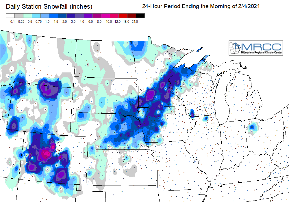
210204_210206_24hour_snowfall_anim.gif
2021-02-07 02:56
228K
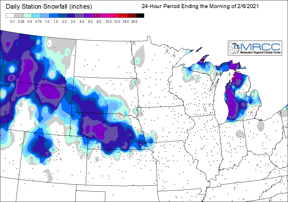
210206_snowfall.png
2021-02-07 02:04
79K
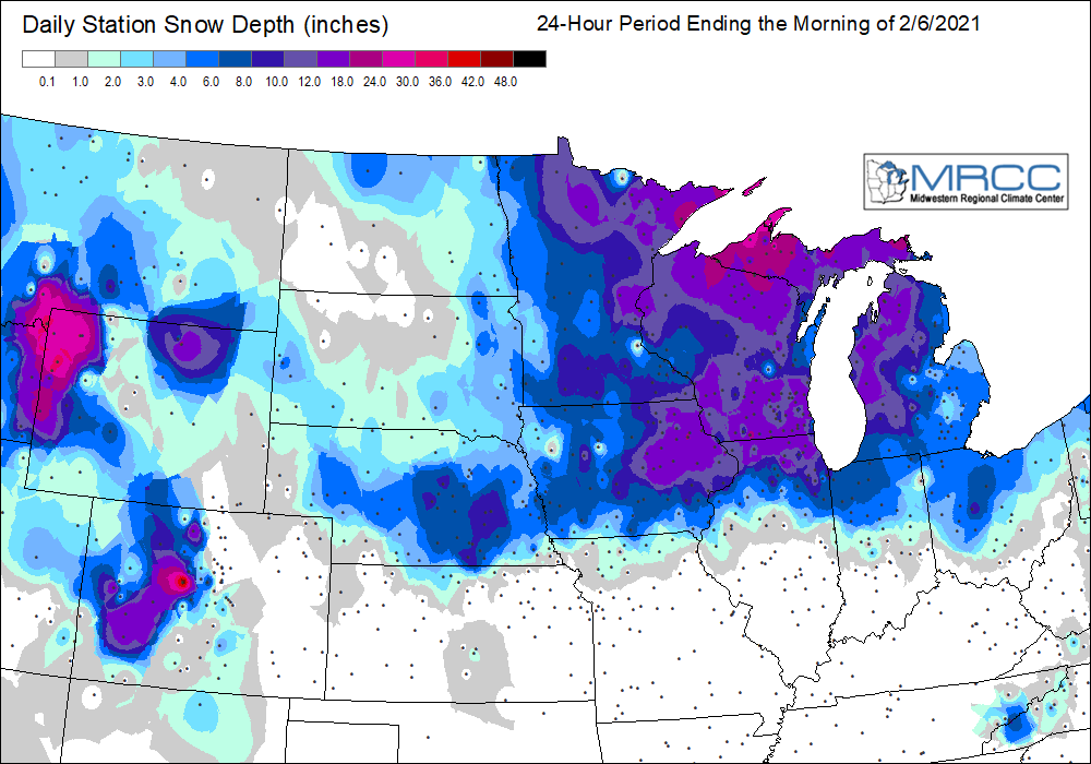
210206_snowdepth.png
2021-02-07 02:04
99K
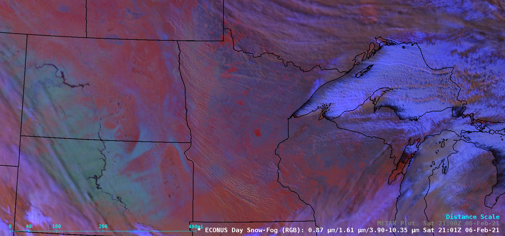
210206_1712utc_landsat8_falseColorRGB_Manitoba_blowing_snow.png
2021-02-07 02:04
2.2M
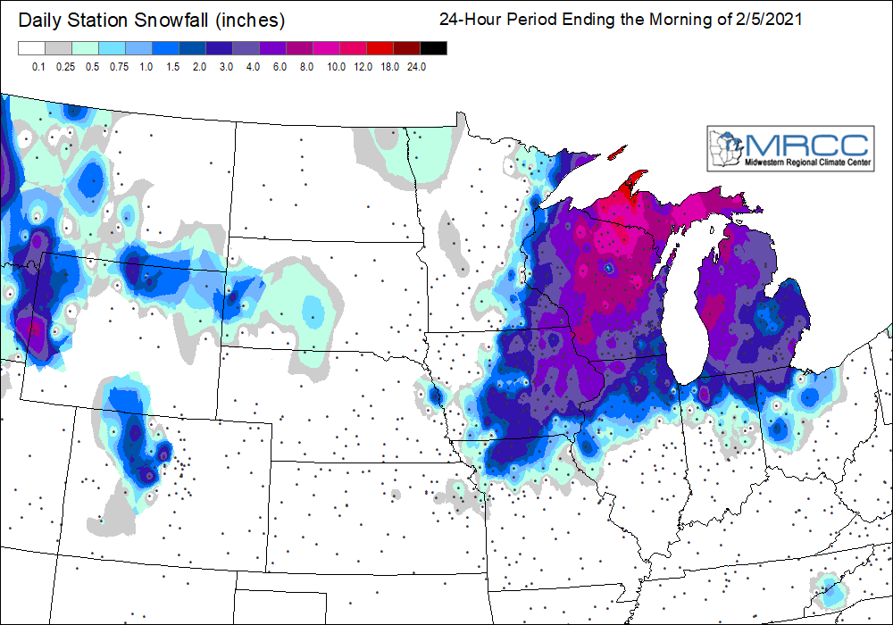
210205_snowfall.png
2021-02-07 02:04
90K
210204_snowfall.png
2021-02-07 02:04
97K
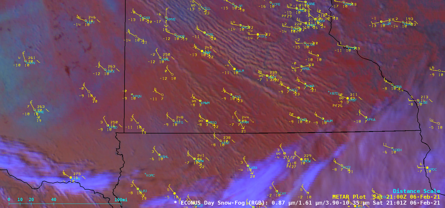
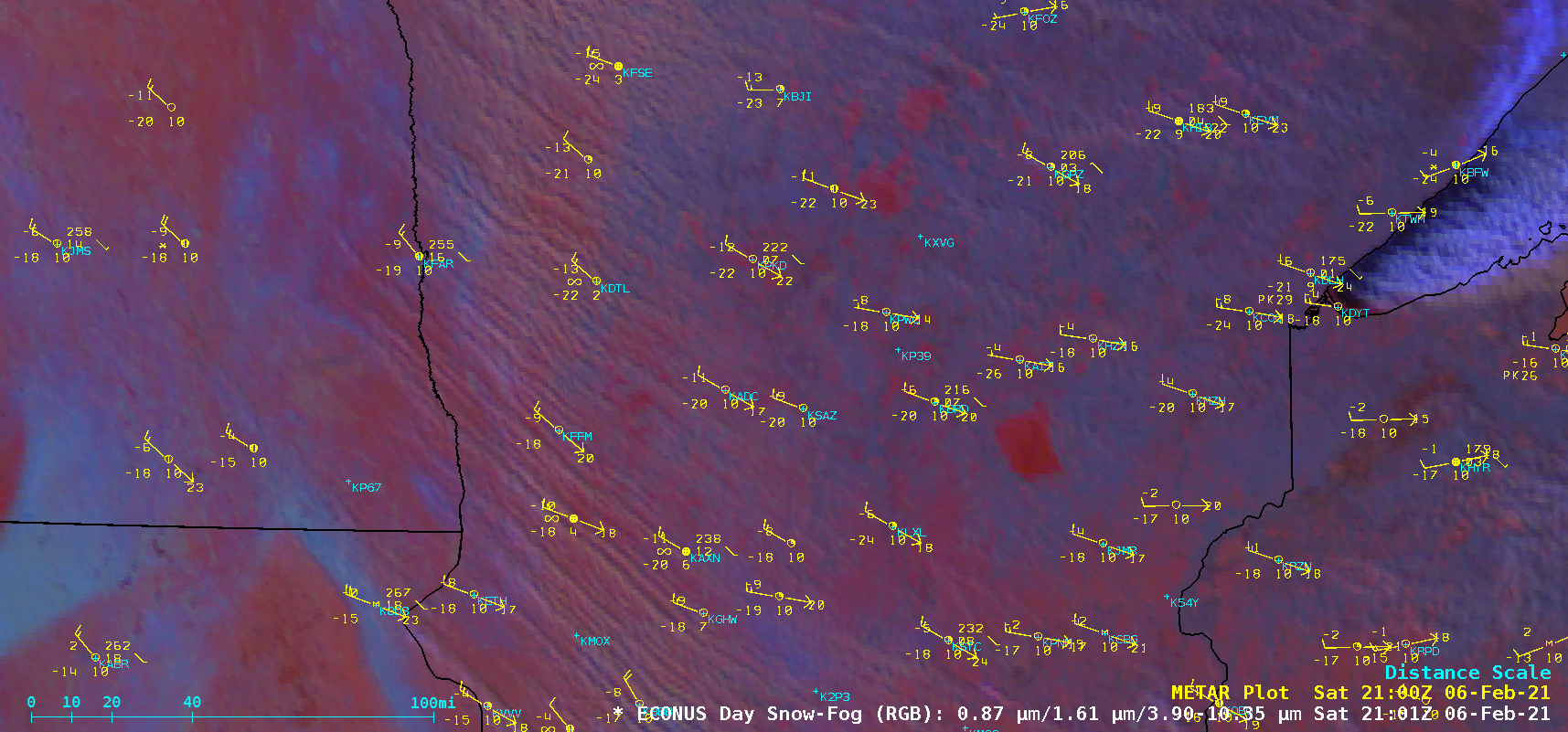
blsn_rgb-20210206_210108.png
2021-02-07 01:40
1.8M
blsn3_rgb-20210206_210108.png
2021-02-07 01:40
1.8M
blsn2_rgb-20210206_210108.png
2021-02-07 01:40
830K
blsn1_rgb-20210206_210108.png
2021-02-07 01:40
761K
210206_goes16_daySnowFogRGB_UpperMidwest_blowing_snow_south_anim.mp4
2021-02-07 01:28
9.1M
210206_goes16_daySnowFogRGB_UpperMidwest_blowing_snow_south_anim.gif
2021-02-07 01:28
116M
210206_goes16_daySnowFogRGB_UpperMidwest_blowing_snow_north_anim.mp4
2021-02-07 01:28
5.8M
210206_goes16_daySnowFogRGB_UpperMidwest_blowing_snow_north_anim.gif
2021-02-07 01:28
120M
210206_goes16_daySnowFogRGB_UpperMidwest_blowing_snow_central_anim.mp4
2021-02-07 01:28
6.3M
210206_goes16_daySnowFogRGB_UpperMidwest_blowing_snow_central_anim.gif
2021-02-07 01:28
119M
210206_goes16_daySnowFogRGB_UpperMidwest_blowing_snow_anim.mp4
2021-02-07 01:27
6.6M
210206_goes16_daySnowFogRGB_UpperMidwest_blowing_snow_anim.gif
2021-02-07 01:27
125M
G16_VIS_S_ATLANTIC_CYCLONE_06FEB2021_2021037_090012_GOES-16_0001PANEL_FRAME0000003.GIF
2021-02-06 19:26
639K
COLD_13_loop_2021036_120013_2021037_135012_8sec.mp4
2021-02-06 14:18
13M
COLD_13_loop_2021036_120013_2021037_135012_3sec.mp4
2021-02-06 14:13
8.0M
210205_South_America_surface_analyses_anim.gif
2021-02-06 03:49
213K
210205_18z_SA_sfc.gif
2021-02-06 03:45
44K
210205_12z_SA_sfc.gif
2021-02-06 03:45
44K
210205_06z_SA_sfc.gif
2021-02-06 03:45
40K
210205_00z_SA_sfc.gif
2021-02-06 03:45
42K
CIMSS_VIS_GOES_loop_2013037_130200_2013037_204500_3sec.mp4
2021-02-06 03:34
3.2M
G16_VIS_S_ATLANTIC_CYCLONE_05FEB2021_2021036_090013_GOES-16_0001PANEL_FRAME0000003.GIF
2021-02-06 02:50
597K
G16_VIS_S_ATLANTIC_CYCLONE_05FEB2021_2021036_084013_GOES-16_0001PANEL_FRAME0000001.GIF
2021-02-06 02:48
539K
G16_VIS_S_ATLANTIC_CYCLONE_05FEB2021_2021036_085013_GOES-16_0001PANEL_FRAME0000002.GIF
2021-02-06 02:42
596K
G16_VIS_S_ATLANTIC_CYCLONE_05FEB2021_2021036_210012_GOES-16_0001PANEL_FRAME0000075.GIF
2021-02-06 02:41
425K
8th_VIS_IR_2x1_loop_2013037_130200_2013037_204500.mp4
2021-02-06 02:00
4.1M
CIMSS__IR_GOES_loop_2013037_130200_2013037_204500.mp4
2021-02-06 01:57
1.3M
CIMSS_VIS_GOES_loop_2013037_130200_2013037_204500.mp4
2021-02-06 01:55
1.5M
210205_suomiNPP_noaa20_viirs_trueColorRGB_South_Atlantic_cyclone_anim.gif
2021-02-06 01:10
2.7M
210205_18z_n20_tc.png
2021-02-06 01:06
2.9M
210205_16z_snpp_tc.png
2021-02-06 01:06
2.8M
210205_goes16_visible_South_Atlantic_cyclone_anim.mp4
2021-02-05 23:18
10M
210205_goes16_visible_South_Atlantic_cyclone_anim.gif
2021-02-05 23:18
46M
GOES-16_ABI_RadF_true_color_2021036_173012Z.png
2021-02-05 21:44
6.1M
GOES-16_ABI_RadF_true_color_2021036_084013Z.png
2021-02-05 21:05
4.8M
GOES-16_ABI_RadF_true_color_2021036_113013Z.png
2021-02-05 20:53
5.2M
GOES-16_ABI_RadF_true_color_2021036_100013Z.png
2021-02-05 20:53
5.4M
GOES-16_ABI_RadF_true_color_2021036_090013Z.png
2021-02-05 20:43
4.7M
G15_WV_05FEB2021_loop_logos.mp4
2021-02-05 15:35
732K
G15_WV_05FEB2021_loop_logos.gif
2021-02-05 15:35
1.5M
G15_WV_05FEB2021_loop.gif
2021-02-05 14:53
1.5M
G15_WV_05FEB2021_loop.mp4
2021-02-05 14:46
639K
ak_viirs_ir-20210204_122157.png
2021-02-05 04:02
1.1M
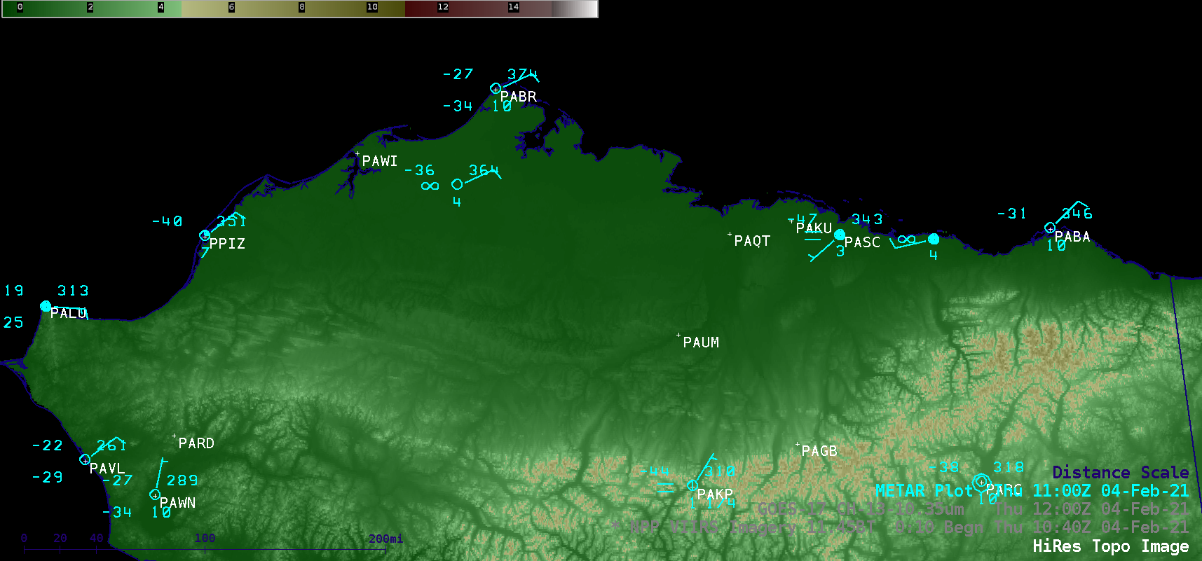
ak_topo-20210204_104056.png
2021-02-05 03:10
423K
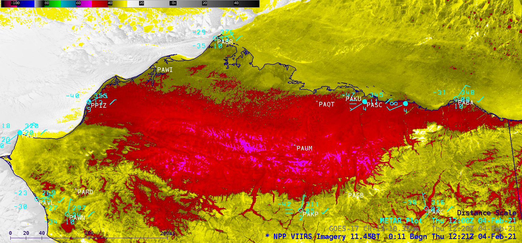
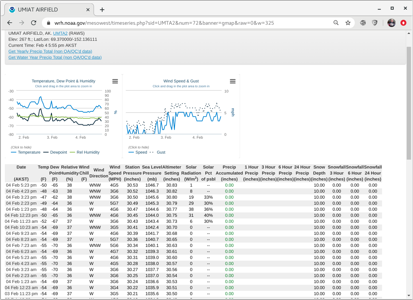
210204_umiat_obs.png
2021-02-05 03:08
306K
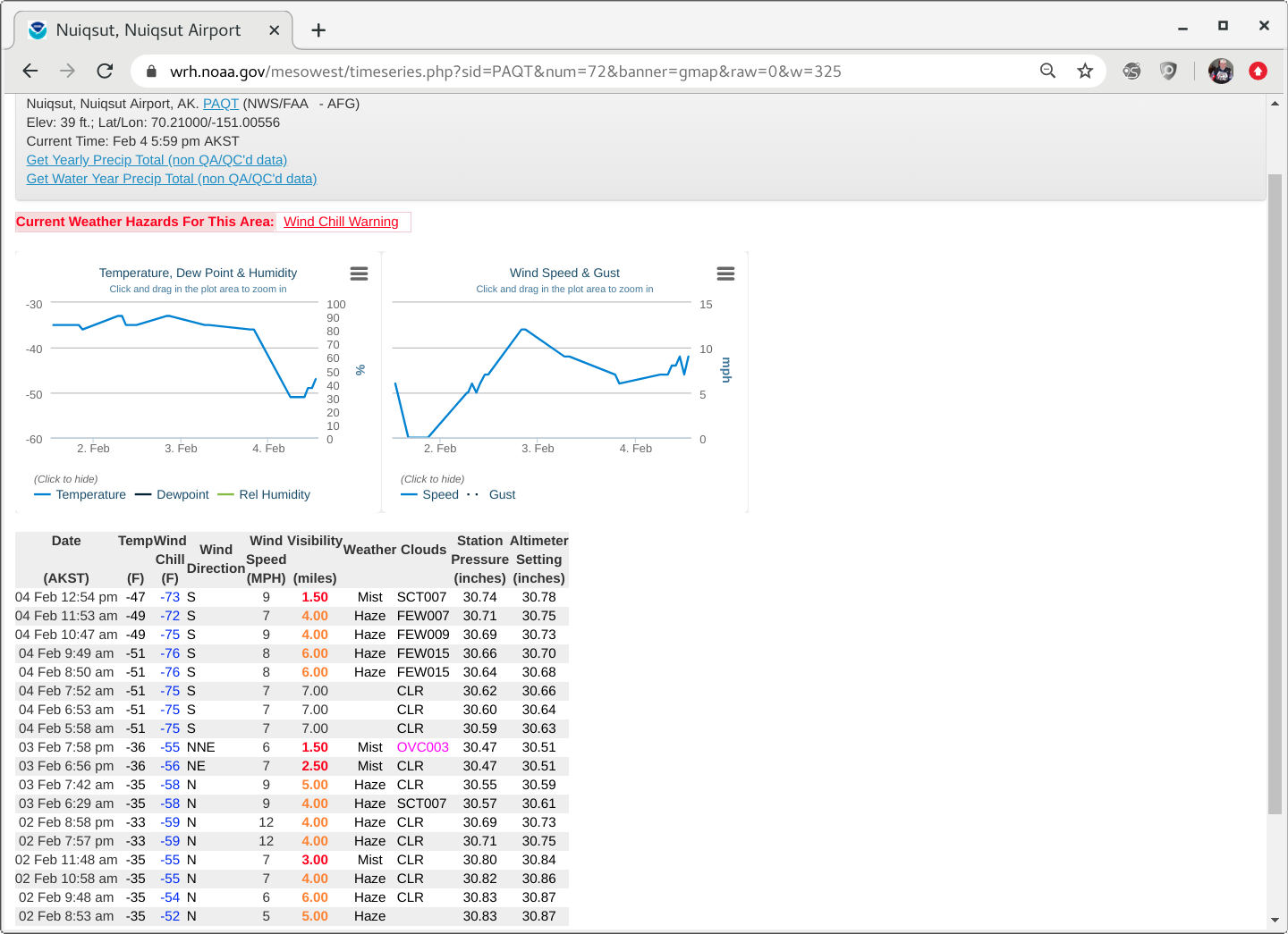
210204_PAQT_obs.png
2021-02-05 03:08
257K
210204_suomiNPP_viirs_infrared_AK_anim.gif
2021-02-05 02:20
6.9M
210204_suomiNPP_goes17_infrared_AK_anim.gif
2021-02-05 02:20
1.0M
210204_goes17_infrared_AK_anim.gif
2021-02-05 02:20
5.4M
210203_suomiNPP_viirs_infrared_AK_anim.gif
2021-02-05 02:20
6.7M
210202_snowfall_pns.text
2021-02-03 23:16
52K
neus_trowal-20210201_180111.png
2021-02-03 17:12
637K
210201_goes16_waterVapor_trowal_Northeast_US_anim.mp4
2021-02-03 16:58
13M
210201_goes16_waterVapor_trowal_Northeast_US_anim.gif
2021-02-03 16:58
150M
210201_goes16_waterVapor_precipType_Northeast_US_small_anim.mp4
2021-02-03 16:15
8.0M
210201_goes16_waterVapor_precipType_Northeast_US_anim.mp4
2021-02-03 16:15
56M
210201_goes16_waterVapor_precipType_Northeast_US_anim.gif
2021-02-03 16:15
313M
ABI_BAND7_2_FIRE_COMBO_CA_loop_2020281_190617_2020284_195617.mp4
2021-02-03 05:05
51M
neus_dmw_vis-20210202_141021.png
2021-02-03 03:37
746K
210202_goes16_visible_derivedMotionWinds_NortheastUS_low_anim.mp4
2021-02-03 03:16
11M
210202_goes16_visible_derivedMotionWinds_NortheastUS_low_anim.gif
2021-02-03 03:16
172M
210202_goes16_visible_ascatWinds_NortheastUS_low_anim.mp4
2021-02-03 01:36
1.6M
210202_goes16_visible_ascatWinds_NortheastUS_low_anim.gif
2021-02-03 01:36
30M
neus_ascat_vis-20210202_131419.png
2021-02-03 01:33
734K
neus_vis-20210202_141219.png
2021-02-03 01:31
738K
ABI_BAND7_2_FIRE_COMBO_CA_Bk_2020281_200117_GOES-17_0001PANEL_FRAME0000061.GIF
2021-02-03 01:23
138K
210202_goes16_visible_NortheastUS_low_anim.mp4
2021-02-02 23:42
9.5M
210202_goes16_visible_NortheastUS_low_anim.gif
2021-02-02 23:42
188M
G16_WV_WX1_NEUS_WINTER_STORM_01FEB2021_B9_2021032_180611_GOES-16_0001PANEL_FRAME0000110.GIF
2021-02-02 20:57
644K
G16_WV_WX1_NEUS_WINTER_STORM_01FEB2021_B9_2021032_180111_GOES-16_0001PANEL_FRAME0000109.GIF
2021-02-02 20:55
383K
GOES16_ABI_1901_to_2001_GLMTOE_1901_to_2000anim_4sec.mp4
2021-02-02 20:38
1.2M
GOES16_ABI_1901_to_2001_GLMTOE_1901_to_2000anim.mp4
2021-02-02 20:30
613K
G16_WV_WX1_NEUS_WINTER_STORM_01FEB2021_B9_2021032_090111_GOES-16_0001PANEL_FRAME0000001.GIF
2021-02-02 19:36
612K
.png)