Wildfire Alert Report
| Date: | 2024-10-24 |
|---|---|
| Time: | 19:21:18 |
| Production Date and Time: | 2024-10-24 19:25:49 UTC |
| Primary Instrument: | GOES-18 ABI |
| Wmo Spacecraft Id: | 665 |
| Location/orbit: | GEO |
| L1 File: | OR_ABI-L1b-RadC-M6C14_G18_s20242981921186_e20242981923559_c20242981924055.nc |
| L1 File(s) - Temporal | OR_ABI-L1b-RadC-M6C14_G18_s20242981916186_e20242981918559_c20242981919044.nc |
| Number Of Thermal Anomaly Alerts: | 2 |
Possible Wildfire
| Basic Information | |
|---|---|
| State/Province(s) | ID |
| Country/Countries | USA |
| County/Locality(s) | Clearwater County, ID |
| NWS WFO | Missoula MT |
| Identification Method | Enhanced Contextual (Cloud) |
| Mean Object Date/Time | 2024-10-24 19:21:24UTC |
| Radiative Center (Lat, Lon): | 46.620000°, -115.740000° |
| Nearby Counties (meeting alert criteria): |
|
| Total Radiative Power Anomaly | n/a |
| Total Radiative Power | 60.64 MW |
| Map: | |
| Additional Information | |
| Alert Status | New Feature |
| Type of Event | Nominal Risk |
| Event Priority Ranking | 4 |
| Maximum Observed BT (3.9 um) | 302.76 K |
| Observed - Background BT (3.9 um) | 12.66 K |
| BT Anomaly (3.9 um) | 5.67 K |
| Maximum Observed - Clear RTM BT (3.9 um) | 25.42 K |
| Maximum Observed BTD (3.9-10/11/12 um) | 31.83 K |
| Observed - Background BTD (3.9-10/11/12 um) | 12.75 K |
| BTD Anomaly (3.9-10/11/12 um) | 4.32 K |
| Similar Pixel Count | 0 |
| BT Time Tendency (3.9 um) | 2.80 K |
| Image Interval | 5.00 minutes |
| Fraction of Surrounding LWIR Pixels that are Colder | 0.71 |
| Fraction of Surrounding Red Channel Pixels that are Brighter | 0.79 |
| Maximum Radiative Power | 60.64 MW |
| Maximum Radiative Power Uncertainty | 0.00 MW |
| Total Radiative Power Uncertainty | 0.00 MW |
| Mean Viewing Angle | 57.90° |
| Mean Solar Zenith Angle | 58.60° |
| Mean Glint Angle | 110.50° |
| Water Fraction | 0.00 |
| Total Pixel Area | 9.30 km2 |
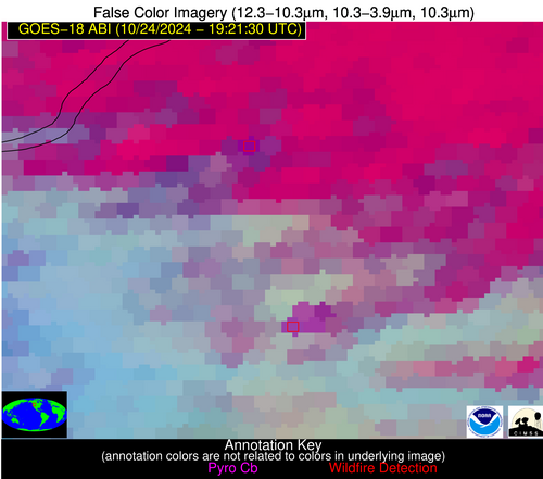
| Latest Satellite Imagery: | |
| View all event imagery » | |
Possible Wildfire
| Basic Information | |
|---|---|
| State/Province(s) | ID |
| Country/Countries | USA |
| County/Locality(s) | Idaho County, ID |
| NWS WFO | Missoula MT |
| Identification Method | Enhanced Contextual (Cloud) |
| Mean Object Date/Time | 2024-10-24 19:21:24UTC |
| Radiative Center (Lat, Lon): | 46.240000°, -115.680000° |
| Nearby Counties (meeting alert criteria): |
|
| Total Radiative Power Anomaly | n/a |
| Total Radiative Power | 82.27 MW |
| Map: | |
| Additional Information | |
| Alert Status | New Feature |
| Type of Event | Nominal Risk |
| Event Priority Ranking | 4 |
| Maximum Observed BT (3.9 um) | 297.49 K |
| Observed - Background BT (3.9 um) | 12.79 K |
| BT Anomaly (3.9 um) | 4.97 K |
| Maximum Observed - Clear RTM BT (3.9 um) | 19.30 K |
| Maximum Observed BTD (3.9-10/11/12 um) | 22.58 K |
| Observed - Background BTD (3.9-10/11/12 um) | 12.94 K |
| BTD Anomaly (3.9-10/11/12 um) | 4.56 K |
| Similar Pixel Count | 0 |
| BT Time Tendency (3.9 um) | 7.40 K |
| Image Interval | 5.00 minutes |
| Fraction of Surrounding LWIR Pixels that are Colder | 0.47 |
| Fraction of Surrounding Red Channel Pixels that are Brighter | 0.62 |
| Maximum Radiative Power | 42.52 MW |
| Maximum Radiative Power Uncertainty | 0.00 MW |
| Total Radiative Power Uncertainty | 0.00 MW |
| Mean Viewing Angle | 57.50° |
| Mean Solar Zenith Angle | 58.20° |
| Mean Glint Angle | 109.80° |
| Water Fraction | 0.00 |
| Total Pixel Area | 18.30 km2 |
| Latest Satellite Imagery: | |
| View all event imagery » | |


