Wildfire Alert Report
| Date: | 2024-06-16 |
|---|---|
| Time: | 19:11:18 |
| Production Date and Time: | 2024-06-16 19:16:14 UTC |
| Primary Instrument: | GOES-16 ABI |
| Wmo Spacecraft Id: | 152 |
| Location/orbit: | GEO |
| L1 File: | OR_ABI-L1b-RadC-M6C14_G16_s20241681911180_e20241681913553_c20241681914040.nc |
| L1 File(s) - Temporal | OR_ABI-L1b-RadC-M6C14_G16_s20241681906180_e20241681908553_c20241681909032.nc |
| Number Of Thermal Anomaly Alerts: | 3 |
Possible Wildfire
| Basic Information | |
|---|---|
| State/Province(s) | IL |
| Country/Countries | USA |
| County/Locality(s) | Pulaski County, IL |
| NWS WFO | Paducah KY |
| Identification Method | Enhanced Contextual (Cloud) |
| Mean Object Date/Time | 2024-06-16 19:11:52UTC |
| Radiative Center (Lat, Lon): | 37.290000°, -89.180000° |
| Nearby Counties (meeting alert criteria): |
|
| Total Radiative Power Anomaly | n/a |
| Total Radiative Power | 44.53 MW |
| Map: | |
| Additional Information | |
| Alert Status | New Feature |
| Type of Event | Nominal Risk |
| Event Priority Ranking | 4 |
| Maximum Observed BT (3.9 um) | 301.53 K |
| Observed - Background BT (3.9 um) | 8.33 K |
| BT Anomaly (3.9 um) | 4.04 K |
| Maximum Observed - Clear RTM BT (3.9 um) | 1.77 K |
| Maximum Observed BTD (3.9-10/11/12 um) | 33.88 K |
| Observed - Background BTD (3.9-10/11/12 um) | 8.38 K |
| BTD Anomaly (3.9-10/11/12 um) | 3.74 K |
| Similar Pixel Count | 0 |
| BT Time Tendency (3.9 um) | 1.80 K |
| Image Interval | 5.00 minutes |
| Fraction of Surrounding LWIR Pixels that are Colder | 0.61 |
| Fraction of Surrounding Red Channel Pixels that are Brighter | 0.88 |
| Maximum Radiative Power | 44.53 MW |
| Maximum Radiative Power Uncertainty | 0.00 MW |
| Total Radiative Power Uncertainty | 0.00 MW |
| Mean Viewing Angle | 45.90° |
| Mean Solar Zenith Angle | 21.20° |
| Mean Glint Angle | 53.90° |
| Water Fraction | 0.00 |
| Total Pixel Area | 6.40 km2 |
| Latest Satellite Imagery: | |
| View all event imagery » | |
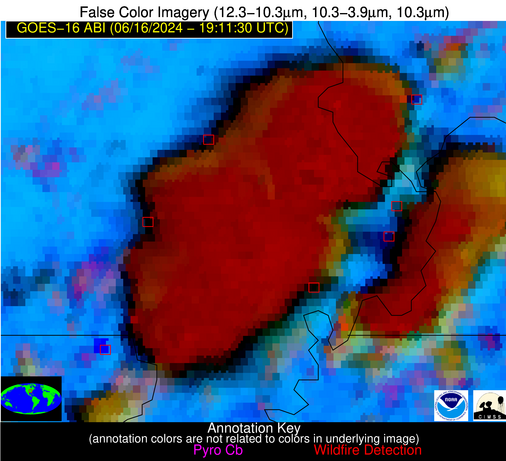
Possible Wildfire
| Basic Information | |
|---|---|
| State/Province(s) | AR |
| Country/Countries | USA |
| County/Locality(s) | Clay County, AR |
| NWS WFO | Memphis TN |
| Identification Method | Enhanced Contextual (Cloud) |
| Mean Object Date/Time | 2024-06-16 19:11:52UTC |
| Radiative Center (Lat, Lon): | 36.450000°, -90.240000° |
| Nearby Counties (meeting alert criteria): |
|
| Total Radiative Power Anomaly | n/a |
| Total Radiative Power | 667.79 MW |
| Map: | |
| Additional Information | |
| Alert Status | New Feature |
| Type of Event | Nominal Risk |
| Event Priority Ranking | 4 |
| Maximum Observed BT (3.9 um) | 339.28 K |
| Observed - Background BT (3.9 um) | 33.80 K |
| BT Anomaly (3.9 um) | 26.51 K |
| Maximum Observed - Clear RTM BT (3.9 um) | 36.92 K |
| Maximum Observed BTD (3.9-10/11/12 um) | 49.59 K |
| Observed - Background BTD (3.9-10/11/12 um) | 32.77 K |
| BTD Anomaly (3.9-10/11/12 um) | 24.83 K |
| Similar Pixel Count | 0 |
| BT Time Tendency (3.9 um) | 33.00 K |
| Image Interval | 5.00 minutes |
| Fraction of Surrounding LWIR Pixels that are Colder | 1.00 |
| Fraction of Surrounding Red Channel Pixels that are Brighter | 1.00 |
| Maximum Radiative Power | 252.81 MW |
| Maximum Radiative Power Uncertainty | 0.00 MW |
| Total Radiative Power Uncertainty | 0.00 MW |
| Mean Viewing Angle | 45.40° |
| Mean Solar Zenith Angle | 20.00° |
| Mean Glint Angle | 52.40° |
| Water Fraction | 0.00 |
| Total Pixel Area | 25.60 km2 |
| Latest Satellite Imagery: | |
| View all event imagery » | |
Possible Wildfire
| Basic Information | |
|---|---|
| State/Province(s) | Unknown |
| Country/Countries | Mexico |
| County/Locality(s) | Mexico |
| NWS WFO | N/A |
| Identification Method | Enhanced Contextual (Clear) |
| Mean Object Date/Time | 2024-06-16 19:13:20UTC |
| Radiative Center (Lat, Lon): | 21.820000°, -98.570000° |
| Nearby Counties (meeting alert criteria): |
|
| Total Radiative Power Anomaly | n/a |
| Total Radiative Power | 51.78 MW |
| Map: | |
| Additional Information | |
| Alert Status | New Feature |
| Type of Event | Nominal Risk |
| Event Priority Ranking | 4 |
| Maximum Observed BT (3.9 um) | 330.17 K |
| Observed - Background BT (3.9 um) | 4.33 K |
| BT Anomaly (3.9 um) | 2.51 K |
| Maximum Observed - Clear RTM BT (3.9 um) | 17.17 K |
| Maximum Observed BTD (3.9-10/11/12 um) | 25.04 K |
| Observed - Background BTD (3.9-10/11/12 um) | 3.49 K |
| BTD Anomaly (3.9-10/11/12 um) | 2.46 K |
| Similar Pixel Count | 25 |
| BT Time Tendency (3.9 um) | 3.60 K |
| Image Interval | 5.00 minutes |
| Fraction of Surrounding LWIR Pixels that are Colder | 0.92 |
| Fraction of Surrounding Red Channel Pixels that are Brighter | 1.00 |
| Maximum Radiative Power | 27.85 MW |
| Maximum Radiative Power Uncertainty | 0.00 MW |
| Total Radiative Power Uncertainty | 0.00 MW |
| Mean Viewing Angle | 36.90° |
| Mean Solar Zenith Angle | 8.60° |
| Mean Glint Angle | 29.50° |
| Water Fraction | 0.00 |
| Total Pixel Area | 11.00 km2 |
| Latest Satellite Imagery: | |
| View all event imagery » | |


