15 June 2026: The GOES-East satellite went into safe mode at 2023 UTC (323pm CDT) following a spacecraft anomaly. No data is being transmitted and the length of outage is unknown.
Wildfire Notification
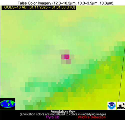
Aid: 898616
Notification Type: Possible Wildfire
Date: 2025-01-11 01:30:55
Show details ▲▼
| Basic Information | |
|---|---|
| State/Province(s) | MS |
| Country/Countries | USA |
| County/Locality(s) | Lowndes County, MS |
| NWS WFO | Jackson MS |
| Identification Method | Enhanced Contextual (Bias) |
| Mean Object Date/Time | 2025-01-11 01:30:59UTC |
| Radiative Center (Lat, Lon): | 33.440000°, -88.570000° |
| Nearby Counties (meeting notification criteria): |
|
| Total Radiative Power Anomaly | n/a |
| Total Radiative Power | 63.72 MW |
| Map: | |
| Additional Information | |
| Notification Status | New Feature |
| Type of Event | Ferrous-metal |
| Event Priority Ranking | 5 |
| Maximum Observed BT (3.9 um) | 294.06 K |
| Observed - Background BT (3.9 um) | 25.98 K |
| BT Anomaly (3.9 um) | 25.17 K |
| Maximum Observed - Clear RTM BT (3.9 um) | 23.16 K |
| Maximum Observed BTD (3.9-10/11/12 um) | 23.76 K |
| Observed - Background BTD (3.9-10/11/12 um) | 25.19 K |
| BTD Anomaly (3.9-10/11/12 um) | 37.02 K |
| Similar Pixel Count | 0 |
| BT Time Tendency (3.9 um) | 24.30 K |
| Image Interval | 1.00 minutes |
| Fraction of Surrounding LWIR Pixels that are Colder | 0.90 |
| Fraction of Surrounding Red Channel Pixels that are Brighter | 1.00 |
| Maximum Radiative Power | 63.72 MW |
| Maximum Radiative Power Uncertainty | 0.00 MW |
| Total Radiative Power Uncertainty | 0.00 MW |
| Mean Viewing Angle | 41.70° |
| Mean Solar Zenith Angle | 119.80° |
| Mean Glint Angle | 102.40° |
| Water Fraction | 0.00 |
| Total Pixel Area | 17.70 km2 |
| Latest Satellite Imagery: | |