Geostationary Operational Environment Satellite (GOES-R) AWIPS IIInstructions for AWIPS II InstallationSpace Science and Engineering Center
|
|
| Project members: Kaba Bah, Scott Bachmeier, Jordan Gerth, Scott Lindstrom | |
| The Space Science and Engineering Center is not continuously staffed. Consequently, data outages and processing issues may result. The products should be considered non-operational. |
Announcements
This data is provided as part of the GOES-R Proving Ground. For assistance and suggestions on obtaining and using the data in AWIPS, please contact Jordan Gerth.
Acquiring Data at a Central Region, Eastern Region, or Southern Region WFO
This page contains information for obtaining WRF-CHEM simulated GOES-R ABI data for display in AWIPS II.
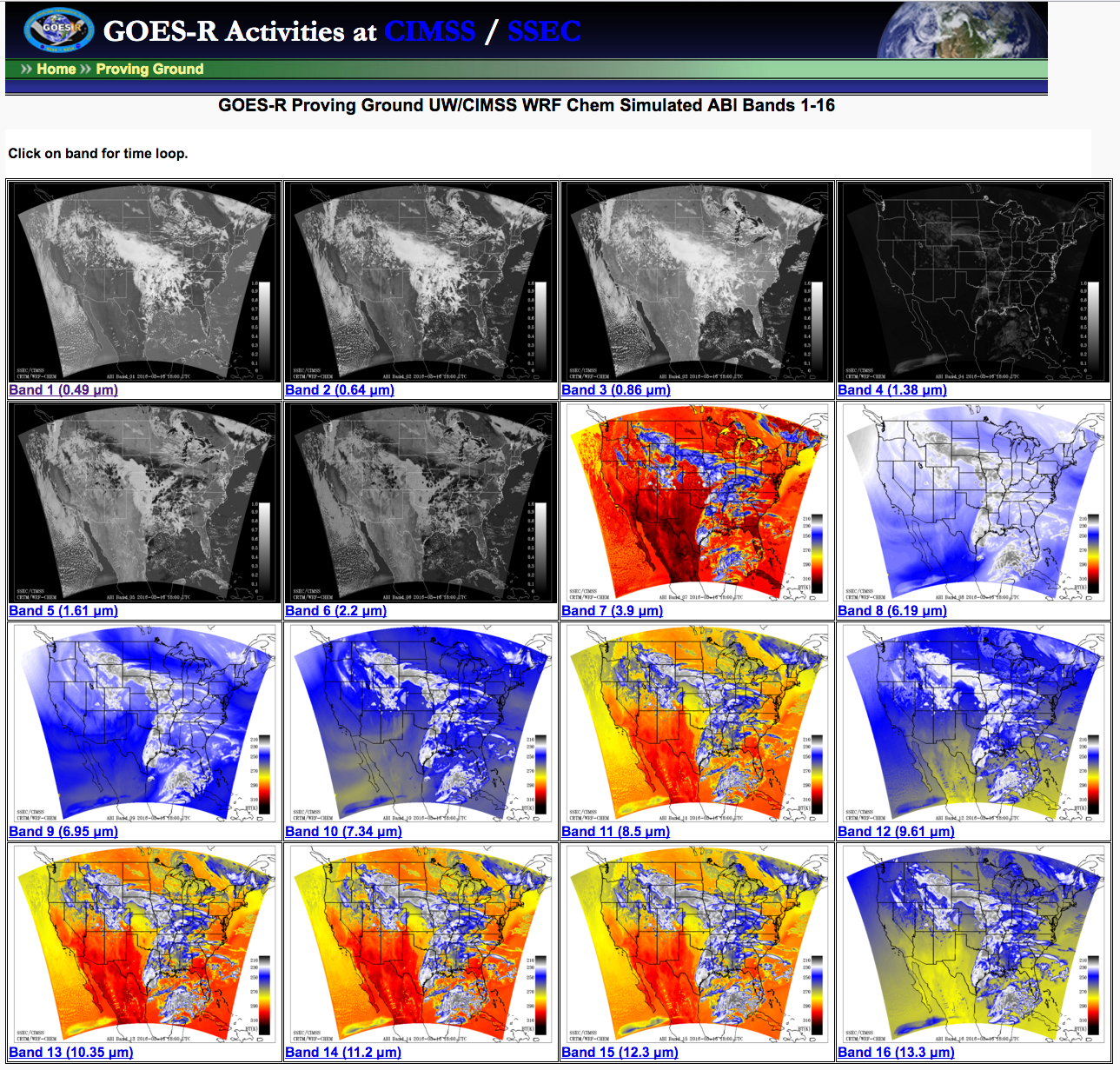
GOES-R Proving Ground UW/CIMSS WRF Chem Simulated ABI Bands 1-16.
Simulated GOESR ABI data is currently available to Weather Forecast Offices in Central Region, Eastern Region, and Southern Region. Data is transmitted in compressed netCDF format on the EXP feed of the Local Data Manager (LDM). This is not an operational dataset, so unplanned data errors and outages may result. Contact Jordan Gerth once you are receiving data so we can add your office to the e-mail announcement list. We value any feedback.
Required AWIPS II Configurations
These files are subject to change as the software evolves.
LDAD/Processing Configurations
Perform the following actions to configure your Local Data Acquisition and Dissemination (LDAD) server.
In /data/fxa/LDAD/data as user ldad on server px2:
- Append to LDADinfo.txt
In /awips/ldad/bin as ldad on px2:
- Add preProcessGOESR.pl and assign executable permissions
- Execute "stopLDAD.sh;startLDAD.csh" to restart the LDAD service
In /awips2/edex/data/utility/ as user awips on dx3 or dx4, where LLL is the WFO identifier:
- Append to edex_static/site/LLL/satellite/regionalsat/creatingEntities.xml
- Append to edex_static/site/LLL/satellite/physicalElements.xml
- Append to edex_static/site/LLL/distribution/regionalsat.xml
Select one of the four "regionalSatImagery*.xml" option that matches your region
- Add custom for visible bandsSq-root-12.cmap to common_static/site/LLL/colormaps/
- Add custom for IR bandsga20p.cmap to common_static/site/LLL/colormaps/
Screenshots
Courtesy of Kaba Bah (contact)
Last updated May 16, 2016