Basic Information | Detailed Product Information

An AWIPS image comparison of the MODIS Band 1 "Visible" channel and the MODIS Band 7 "Snow/Ice" channel over the central US on 13 February 2008 is shown above. Snow cover and/or ice cover on the ground is a strong absorber at the 2.1 µm wavelength, so those features appear darker on the "Snow/Ice" image (in contrast to supercooled water droplet cloud features, which appear as brighter features). In fact, ice is a stronger absorber than snow - note that the area of ice accrual in southern Missouri (from an ice storm 24 hours earlier) appears even darker than the area of deeper snow cover to the north over Iowa.
Who is developing and distributing this product?
The Cooperative Institute for Meteorological Satellite Studies (CIMSS) in Madison, Wisconsin is developing and distributing this product.
Who is receiving this product, and how?
The MODIS Band 7 "Snow/Ice" imagery is being sent to the National Weather Service (NWS) Central, Southern, Western, and Eastern Region Headquarters, allowing any interested NWS forecast office within those regions to add the MODIS imagery to their local AWIPS. To date, a total of 30 NWS forecast offices have added the CIMSS MODIS images and products to their local AWIPS.
What is the product size?
The size of an individual CONUS-scale MODIS swath image is approximately 50 MB. The MODIS Snow/Ice images are nominally available 2 times per day (around 11am and 1pm local time) over any given region.
Purpose of this product
The purpose of the MODIS Band 7 2.1 µm imagery is to help discriminate between snow (or ice) on the ground and supercooled water droplet cloud (or fog) features. Snow and/or ice on the ground is a strong absorber at the 2.1 µm wavelength, so it appears as darker features on the Snow/Ice image (in contrast to supercooled water droplet clouds, which appear as brighter features on the imagery).
Why is this a GOES-R Proving Ground Product?
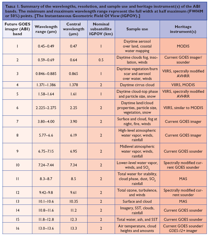
The GOES-R satellite will feature the Advanced Baseline Imager (ABI) instrument, which will make several new channels (including a 1.61 µm and a 2.25 µm "snow/ice discrimination" channel) avaiable to forecasters.
How is this product created now?
MODIS imagery is obtained via the University of Wisconsin MODIS Direct Broadcast ground station, re-formatted for display AWIPS, and distributed to NWS forecast offices (via Unidata LDM subscription).
Product Examples and Interpretation


