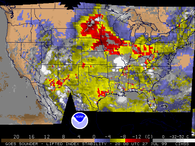
27 July 1999 -- Lifted Index Shows Instability Over The Great Plains
The hourly stability products derived from temperature/moisture profiles based on
GOES-8/10
sounder successfully captured the region of instability in the Great Plains
over the course of July 27, 1999. Note the convection forming over the center
of instability over the Dakotas. Numerous severe thunderstorm and tornado
warnings were subsequently issued as a result of these
storms.
These links will take you to the
GOES Derived Products within this page.
Here you will find GIF images and FLI animations:
Lifted Index
| Precipitable Water | CAPE
| Cloud Top Pressure
 FLI
(3766284 bytes) Animation
(FLI Player Information)
FLI
(3766284 bytes) Animation
(FLI Player Information)
GIF Images for 28 Jul 99
GIF Images for 27 Jul 99
23:00 UTC
, 22:00 UTC
, 21:00 UTC
, 20:00 UTC
, 19:00 UTC
, 18:00 UTC
, 17:00 UTC
, 16:00 UTC
, 15:00 UTC
, 14:00 UTC
, 13:00 UTC
, 12:00 UTC
, 11:00 UTC
, 10:00 UTC
, 9:00 UTC
, 8:00 UTC
, 7:00 UTC
, 6:00 UTC
 GOES Sounder LI stability with accompanying radiosonde values
Lifted Index from 12Z 27 July and 00Z 28 July
show high correlation (0.93) between sounder derived values and radiosonde
reported values. The GOES Sounder
can provide a picture of what happens between radiosondes (in space and time), as evidenced in the
20Z GOES Sounder Lifted Index image.
Eta Model Lifted Index Products and Severe Weather
Numerous severe thunderstorm and tornado warnings were issued
with these storms. The warnings, valid between 20 and 22 UTC, have been
over-plotted on the sounder Lifted Index image from 19 UTC (July 27, 1999).
The 06-hr Eta forecast (from the 12 UTC run) also captured the region of
large instability over the central Dakotas. The Eta forecast of the parcel
LI is over-plotted on the sounder Lifted Index from 18 UTC (July 27, 1999).
The 12-hr Eta forecast (from the 12 UTC run) also captured the region of
large instability over Minnesota. The Eta forecast of the parcel LI is
over-plotted on the sounder Lifted Index from 00 UTC (July 28, 1999).
Combined GOES-8/10 Coverage
FLI
(2740910 bytes) Animation
(FLI Player Information)
GIF Images for 28 Jul 99
GIF Images for 27 Jul 99
23:00 UTC
, 22:00 UTC
, 21:00 UTC
, 20:00 UTC
, 19:00 UTC
, 18:00 UTC
, 17:00 UTC
, 16:00 UTC
, 15:00 UTC
, 14:00 UTC
, 13:00 UTC
, 12:00 UTC
, 11:00 UTC
, 10:00 UTC
, 9:00 UTC
, 8:00 UTC
, 7:00 UTC
, 6:00 UTC
FLI
(3718218 bytes) Animation
(FLI Player Information)
GIF Images for 28 Jul 99
GIF Images for 27 Jul 99
23:00 UTC
, 22:00 UTC
, 21:00 UTC
, 20:00 UTC
, 19:00 UTC
, 18:00 UTC
, 17:00 UTC
, 16:00 UTC
, 15:00 UTC
, 14:00 UTC
, 13:00 UTC
, 12:00 UTC
, 11:00 UTC
, 10:00 UTC
, 9:00 UTC
, 8:00 UTC
, 7:00 UTC
, 6:00 UTC
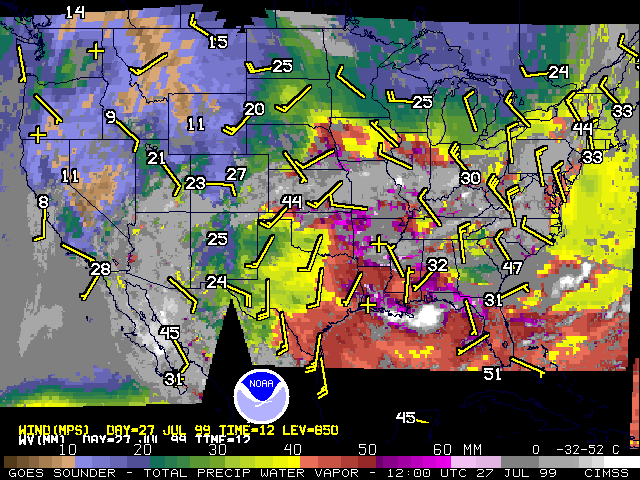
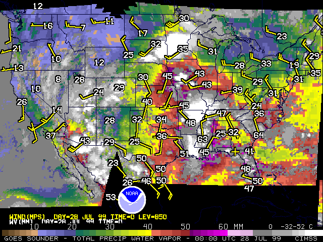
The 12 UTC GOES PW DPI for July 27, 1999 and the 00 UTC GOES PW DPI for July 28, 1999
are shown here with their corresponding
12
and
00
UTC radiosonde values of total precipitable water vapor (in mm) and 850 mb
wind flags. The winds have been included to provide a sense of the mean
lower level flow pattern which strongly impacts the transport of the PW.
FLI
(3043294 bytes) Animation
(FLI Player Information)
GIF Images for 28 Jul 99
GIF Images for 27 Jul 99
23:00 UTC
, 22:00 UTC
, 21:00 UTC
, 20:00 UTC
, 19:00 UTC
, 18:00 UTC
, 17:00 UTC
, 16:00 UTC
, 15:00 UTC
, 14:00 UTC
, 13:00 UTC
, 12:00 UTC
, 11:00 UTC
, 10:00 UTC
, 9:00 UTC
, 8:00 UTC
, 7:00 UTC
, 6:00 UTC
Combined GOES-8 and GOES-10 Cloud Top Pressure
FLI
(3819946 bytes) Animation
(FLI Player Information)
GIF Images for 28 Jul 99
GIF Images for 27 Jul 99
23:00 UTC
, 22:00 UTC
, 21:00 UTC
, 20:00 UTC
, 19:00 UTC
, 18:00 UTC
, 17:00 UTC
, 16:00 UTC
, 15:00 UTC
, 14:00 UTC
, 13:00 UTC
, 12:00 UTC
, 11:00 UTC
, 10:00 UTC
, 9:00 UTC
, 8:00 UTC
, 7:00 UTC
, 6:00 UTC
Please refer questions to the GOES Webmasters

Back to the CIMSS home page