09 March 1999 -- Heavy Snow Over the Mid-Atlantic Region
|
|
|
|
|
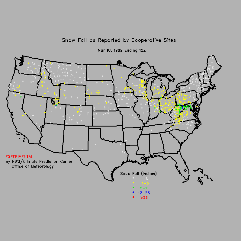
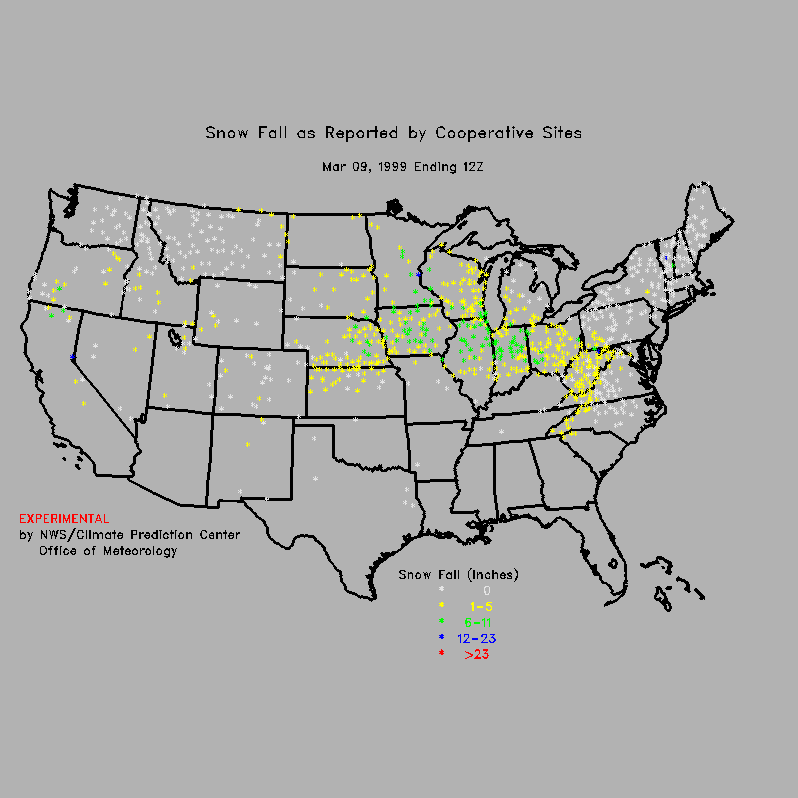
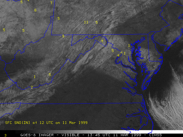
Heavy snow fell over much of the central Appalachians and Mid-Atlantic region during the day on 09 March 1999. Maximum accumulations included 14 inches in West Virginia and Maryland, 11 inches in the Washington DC area, 10 inches in Pennsylvania, and 6 inches in Ohio and the mountains of western North Carolina. This storm system had produced significant snowfall across the Midwest and southern Great Lakes region on the previous day (including 16 inches at Minneapolis MN), before it moved southeastward toward the East Coast. A NOAA GOES-8 visible image from 2 days later shows the pattern of snow cover left by this storm.
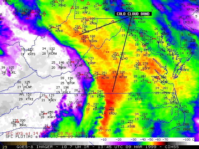
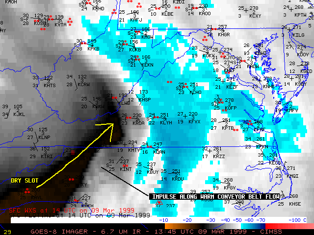
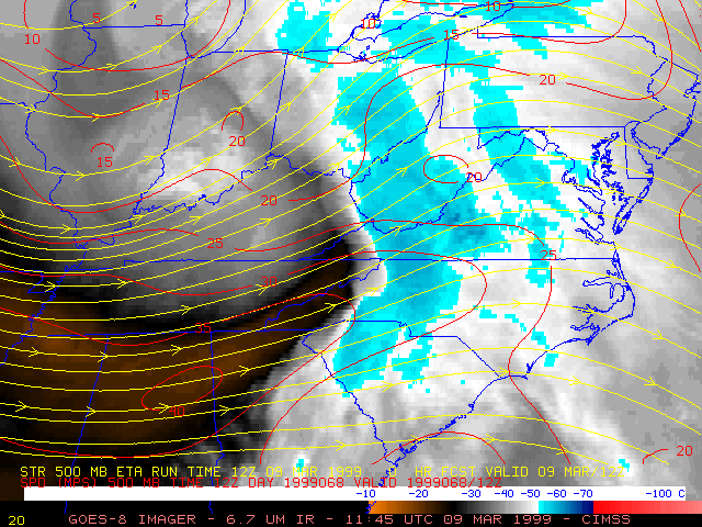
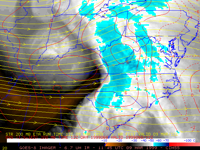
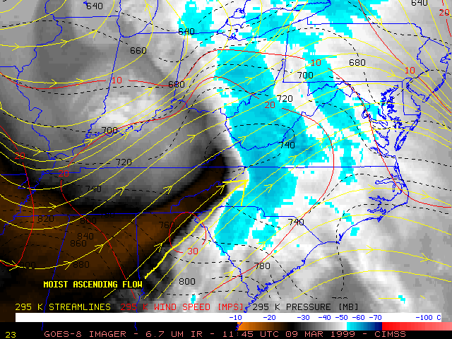
GOES-8 10.7 micrometer InfraRed (IR) imagery (above left) and 6.7 micrometer IR ("water vapor") imagery (above right) shows that a mid-level dry slot (500 mb analysis | 310 K analysis) was advancing rapidly east-northeastward across the region. A distinct band of cold cloud tops (temperatures of -50 to -60 C) exhibiting a concave trailing edge was evident along the leading edge of the dry slot. This cold cloud band lined up well with the pattern of upper-tropospheric divergence (250 mb | 200 mb), indicating deep synoptic-scale rising motion within the layers below.
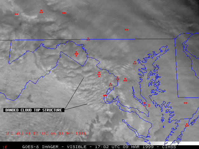
Initial bands of light snow helped to moisten the very dry low-level air mass (surface dewpoints were generally 10-15 F or lower prior to the arrival of the light snow). Snowfall rates were then enhanced as the main cold cloud band moved through the region, with many stations reporting moderate to heavy snow for several hours. High-resolution GOES-8 visible imagery (17:02 UTC | Java animation) revealed a "banding" structure of the cloud tops immediately behind the trailing edge of the cold cloud band. This banding can be a signature of precipitation enhancement due to strong frontogenetic forcing from isentropic lift and warm air advection, or also in regions where Conditional Symmetric Instability (CSI) is released through moist slantwise convection [ see RUC-2 model diagnostics from this case, courtesy of Dave Schultz, NOAA/NSSL]. "Feeder-seeder" processes may also have been at work, with convective "generating cells" located within the elevated warm air advection zone seeding the stratiform cloud layers within the inversion layer below.
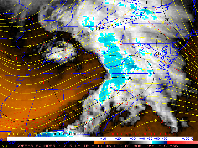
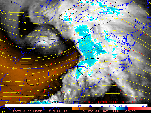
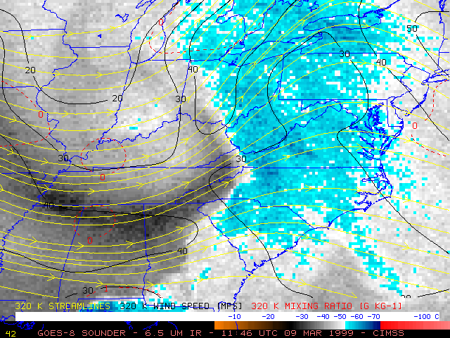
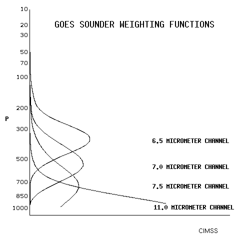
Of particular interest are the "ripples" seen in the water vapor imagery, which propagated rapidly northeastward across western North Carolina into central Virgina between 12:00 and 17:00 UTC. These features appeared to be pulses of rising motion within the low-level jet / warm conveyor belt flow regime that existed just east of the Appalachians. Using the 3 water vapor channels (7.5, 7.0, and 6.5 micrometers) from the GOES-8 Sounder (below), it becomes easier to detect evidence of the northeastward transport of moisture within the warm conveyor belt flow (the warmer gray to black enhanced features, originating in southern Alabama and northern Georgia on the 7.5 and 7.0 micrometer Sounder channels), as well as the core of the mid-level dry slot (the warmer gray to black enhanced band on the 6.5 micrometer Sounder channel, located just north of the 40 m s-1 jet streak from southwestern Tennessee into northern Alabama, northern Georgia, and western North Carolina).
|
|
|
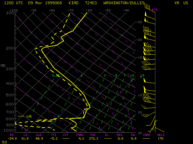
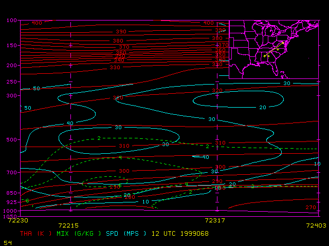
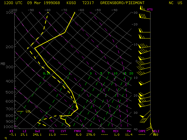
A vertical cross section from Alabama to Washington DC shows that moist low-level southwesterly flow along the 295 K isentropic surface was ascending from about 800 mb over northcentral Georgia to around 730 mb over western North Carolina. The Greensboro NC rawinsonde shows the Lifting Condensation Level (LCL) near the 730 mb pressure level; subsequent lifting of air parcels within this warm conveyor belt flow would have resulted in moist adiabatic ascent into the middle and upper troposphere. This moist ascending flow fed into the rear portion of the main cold cloud band, helping to prolong the moderate to heavy snowfall rates over the Delmarva region. Also note that the deep moist layers on the Greensboro NC and Washington DC rawinsondes span a large range of sub-freezing temperatures -- this type of sounding profile indicates that ice crystal growth by aggregation was likely. Ice crystal growth by riming was also probable, as ice crystals formed in the -10 to -20 C layer aloft (500 to 600 mb) and fell through a deep layer of saturated air near -5 C (where large concentrations of supercooled water droplets likely existed). The low-level dry layers at these two locations became saturated (via evaporation) by the inital bands of light snow that preceeded the moderate to heavy snow within the main cold cloud band.
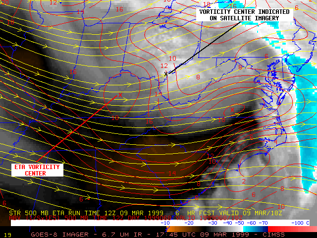
During the 18:00 UTC to 23:00 UTC time frame, a lobe of vorticity can be seen moving eastward across West Virgina toward the Washington DC area. Upward vertical motion ahead of this vorticity feature helped to enhance showfall rates later in the day (Washington DC reported heavy snow again around 00:00 UTC). The 6-hour 500 mb forecast from the 12:00 UTC Eta model appeared to be a bit slow with this vorticity lobe, locating the feature farther to the west (over northern Kentucky) at 18:00 UTC.
