08 July 1997 -- Mesoscale Convective Complex decays,
revealing a Mesoscale Vorticity Center

GOES-8 IR image

11:45 UT GOES-8 IR image

GOES-8 IR image

18:45 UT GOES-8 IR image

(15-image Animation)

A Mesoscale Convective Complex (MCC) formed late in the day on 07 July 1997 over Nebraska, and produced heavy rainfall amounts as it propagated southeastward across Kansas and Missouri during the nighttime hours. Early in the day on 08 July, the cold cirrus canopy of the MCC (cloud top temperatures less than -40 C) rapidly dissipated as the system decayed. The thinning of the high cloud shield revealed that a Mesoscale Vorticity Center (MVC) had formed in response to persistent mid-level convergence between inflow and outflow circulations within the rear "stratiform precipitation region" of the MCC. This small MVC circulation then moved eastward across Missouri, while the outflow boundary from the MCC provided a focus for new convective activity as it moved southward into Arkansas.

The MVC (also known as a Mesoscale Convective Vortex (MCV) or a "Neddy eddy" **) is best seen in an animation of visible imagery, appearing as a cyclonic spiral moving toward Saint Louis, MO. The circulation was also evident on WSR-88D radar composites as it deformed the precipitation into a hooklike pattern. The GOES-8 sounder-derived lifted index revealed that the atmosphere quickly destabilized (LI's less than -8 C) once the clouds dissipated and surface heating could take place. New convection did indeed redevelop in the vicinity of the MVC after 20:00 UT over eastern Missouri.

(** named after Edward "Ned" Johnston, a NWS meteorologist who first identified such a feature in GOES imagery)

A NOAA Profiler time series from Lathrop, MO (just northeast of Kansas City, MO) shows how the deep westerly flow was perturbed as the MCC and it's mid-level MVC developed and moved eastward. Note the northerly and northeasterly flow within the 4-8 km layer, during the 09:00 to 16:00 UT time frame. Another feature typically exhibited by MCC's that produce a MVC is a well-defined anticyclonic outflow aloft (near the storm top altitude). This outflow was evident from the filaments of cirrus streaming out of the southern and southeastern edges of the cirrus canopy.

It is interesting to note that this mesoscale vortex could be identified for the following two days as it propagated across Kentucky, Tennessee, and the southern Appalachians, eventually exiting the South Carolina coast late in the day on 10 July.

GOES-8 sounder LI

GOES-8 sounder and rawinsonde
Lifted Index (LI)

GOES-8 sounder LI

6-panel GOES-8 sounder LI
and SPC watch boxes

The western portion of the outflow boundary from this MCC remained semi-stationary over Kansas -- this surface feature acted as a focusing mechanism for new convection later in the day. Rawinsonde and GOES-8 sounder Derived Product Image (DPI) of Lifted Index (LI) values (left) show the large region of very unstable atmosphere (negative LI) from Nebraska into Texas, while a 6-panel sequence of GOES-8 sounder DPI LI (right) illustrates the strong de-stabilization that occurred over central Kansas and northcentral Oklahoma during the afternoon hours.

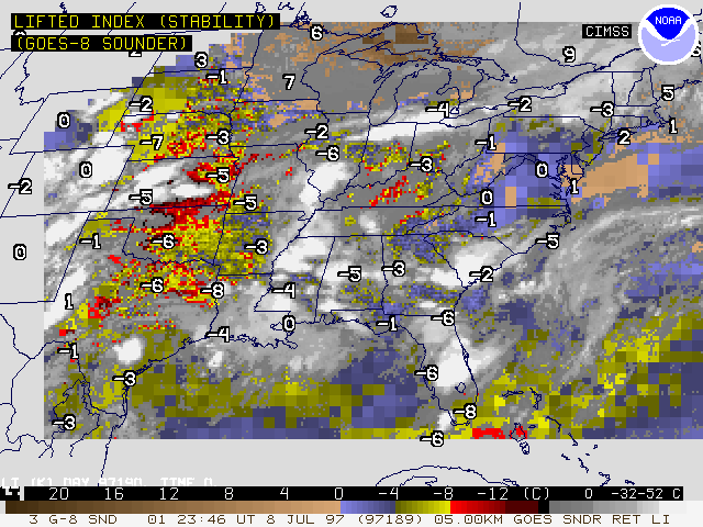
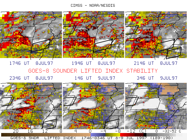
The Storm Prediction Center (SPC) had issued severe thunderstorm watches in anticipation of the convection over Arkansas and eastern Colorado, but the strong to severe convective activity over central Kansas was not covered by a watch. This activity produced several reports of hail (up to 1.75 inches diameter) and damaging wind gusts (up to 60 mph), along with heavy rainfall amounts of 4-6 inches across parts of Kansas. The pre-existing outflow boundary along with the strong and focused de-stabilization as indicated by the LI DPI sequence would seem to have presented supporting evidence to have considered an additional severe thunderstorm watch for that region.


Back to Interesting Images page