
|

|
|
|
|
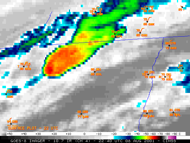
NOAA GOES-8 visible and 10.7 micrometer InfraRed (IR) channel imagery (above) shows the development of severe convection that produced tornadoes, large hail and damaging winds across parts of North Dakota and Minnesota during the afternoon and evening of 08 August 2001. Thunderstorm downburst winds gusted to 114 mph at Grand Forks Air Force Base ND (station identifier KRDR) at 01:16 UTC (8:16 PM Central time), 101 mph at the Grand Forks ND National Weather Service office (near KGFK) at 01:26 UTC (8:26 PM Central time), and 79 mph at 01:56 UTC (8:56 PM Central time) at Crookston MN (KCKN). Well-defined overshooting tops were evident on the visible imagery, and IR imagery indicated cloud top temperatures as cold at -68 C (dark red enhancement) to the northwest of Grand Forks just prior to the damaging winds at the surface. Less than 24 hours earlier, other thunderstorms had produced winds gusting to 110 mph at Hillsboro ND, just 35 miles south-southeast of Grand Forks.
IR images from overpasses of the NOAA-14 and NOAA-15 polar orbiting satellites are shown below. The higher resolution of the AVHRR IR detectors (1km, versus 4km on GOES) reveals greater detail in the structure of the cloud top temperature field. An "enhanced-v" signature became apparent on the GOES-8 IR imagery around 22:40 UTC, but the signature is more obvious on the 22:58 UTC NOAA-14 image (below, left). The storm was producing large hail (1.00 and 1.50 inches in diameter) around the time of the NOAA-14 image. In addition, the AVHRR cloud top temperatures in the overshooting top regions were significantly colder (5 to 13 C) than those measured by GOES-8. The IR image from the 01:37 UTC overpass of NOAA-15 (below, right) was about 11 minutes after the 101 mph wind gust at the Grand Forks NWS office, and about 19 minutes before the 79 mph gust at Crookston (CKN) -- cloud tops as cold as -81 C (light purple enhancement) were detected (compared to -67 C on GOES-8 at that time).

|

|

|

|
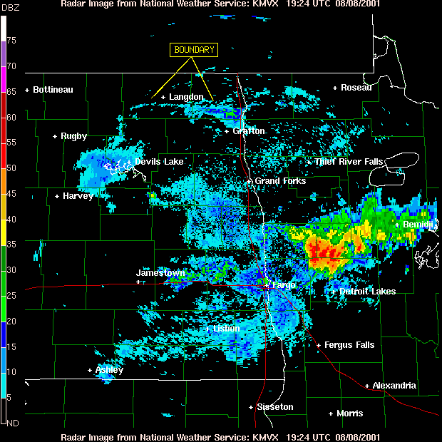
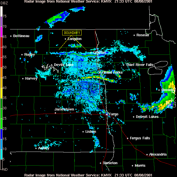
Grand Forks WSR-88D radar base velocity data showed inbound velocities of 50-64 knots as the storm was approaching Grand Forks at 01:04 UTC (above), and outbound velocities of 50-64 knots as the storm was passing Crookston MN at 02:00 UTC (above, right). Radar base reflectivity data also revealed a west-east oriented boundary (19:24 UTC | 21:33 UTC | 23:37 UTC | - Animation -) moving southward through the Grafton region toward Grand Forks as the convection was approaching from the west. This boundary may have played a role in the intensification and motion of the convection as it moved through northeastern North Dakota and northwestern Minnesota.

|

|

|

|

