Science
ASAP science covers a number of objectives in six categories:

- Develop satellite-based information that will aid
in the realtime nowcasting of convective initiation (CI) and the diagnosis
of convection on meso- and synoptic scales.
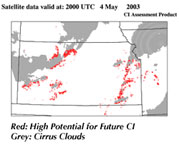
- Develop a series of CI “interest fields” from existing satellite
sensors (e.g. GOES, MODIS) that can help predict future convection on local
scales (i.e., 1-4 km).
- Develop new methods for using hyperspectral data for accomplishing these
goals.
Related Web site:
CIMSS
Convective Studies
|
 |
|

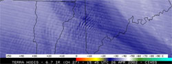
- Develop satellite-based techniques to identify and characterize regions
of moderate and severe clear-air (e.g., mountain waves), and cloud-induced
turbulence (e.g., thunderstorms), as detectible in GOES, and especially MODIS
infrared data.
- Develop value-added products of turbulence from satellite data sets that
can be used in conjunction with numerical simulation and existing PDT turbulence
prediction systems.
|
 |
|

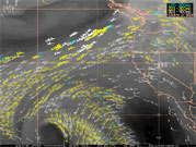
- Apply satellite-based information that will aid in the forecasting and
analysis of hazardous weather over oceans. Overlaps with other PDT efforts.
- Use products that help identify regions of high flight-level winds, dust,
turbulence, convection, and clouds that can assist in trans-oceanic travel.
|
|
|

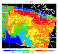
- Develop satellite-based information that will aid in the realtime diagnosis
of cloud microphysical properties and cloud type.
- Emphasize use of MODIS imagery and other high-spectral resolution data.
|
 |
|

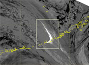
- Develop satellite-based information that will aid in the realtime diagnosis
of volcanic ash, ash clouds
and ash characteristics.
- Emphasize use of MODIS imagery and other high-spectral resolution data.
Related Web site:
Committee on Earth Observation Satellites (CEOS) Volcanic Hazard Assessment |
|
|

- Incorporate satellite-derived winds to identify possible turbulent regions
associated with upper tropospheric jets.
|
|