Station Model
A simplified example of a station model plot used to represent
meteorological conditions near the surface is shown in the accompanying
figure. The station model depicts current weather conditions, cloud cover,
wind speed, wind direction, visibility, temperature, dew point temperature,
atmospheric pressure adjusted to sea level, and the change in pressure
over the last three hours. Nine weather variables commonly reported on
the evening news are plotted in the figure.
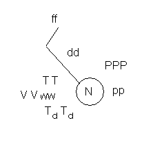 The circle in the station model is centered on the latitude
and longitude of the city where the weather observations are made. Total
cloud cover is expressed as the fraction of cloud covering the sky. An
open circle represents a clear sky and an overcast sky is represented by
a filled-in circle. The coding legend for all types of cloud cover is available
in your book.
The circle in the station model is centered on the latitude
and longitude of the city where the weather observations are made. Total
cloud cover is expressed as the fraction of cloud covering the sky. An
open circle represents a clear sky and an overcast sky is represented by
a filled-in circle. The coding legend for all types of cloud cover is available
in your book.
In the United States surface temperature is expressed
in degrees Fahrenheit. In the station model plot, temperature is plotted
where the number 10 is on a clock (TT). The dew point temperature (TdTd)
is plotted below (at about 8 o'clock) and in the same units as temperature.
Visibility (VV) is how far we can see and (in the United States) is expressed
in units of miles. On the station model, visibility is plotted between
temperature and dew point (at about 9 o'clock). Immediately to the right
of visibility is current weather conditions. Symbols of current weather
are given in your book.
Wind speed and direction are represented in the station
model plot by the position of the ?flag pole.? The pole points to the direction
from which the wind is coming. You can tell which direction the ?pole?
is pointing by the end that has the flags or barbs.
AOS100
Home page |
Next Page | Practice
Exercises | Previous
Page
Written by Steve Ackerman and Tom Whittaker
Copyright© 1997