An object at rest will remain at rest and an object in motion will remain in motion (and travel at a constant velocity along a straight line) as long as no force is exerted on it.
The force exerted on an object equals its mass times the acceleration produced. Pushing is a simple form of a force, direction of acceleration depends on direction of the force exerted. When we discuss forces we are interested in how strong they are and the direction they act.
I. Pressure Gradient Force - directed from higher pressure towards lower pressure at right angles to the isobars. Contour lines on a constant pressure chart or isobaric chart, tell us the altitude above sea level at which one obtains a given pressure reading (i.e., 500 mb isobaric map). Cold air aloft is normally associated with low heights. Surface Pressure chart - near the earth's surface the pressure decreases by about 10 mb for every 100 meter increase in elevation.
II. Coriolis Force -- describes an apparent force that is due to the rotation of the earth.
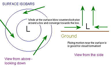
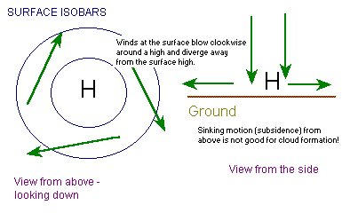
Geostrophic wind -- balance between PGF and CF. In the northern hemisphere lower pressure is to the left. Winds blow counter clockwise around a low pressure system and clockwise around a high in the northern hemisphere.
III. Friction. Friction always acts in the direction opposite to movement. If there is no movement friction is zero. The magnitude is a function of the type of surface. Friction is small over a frozen lake and strong in forest.
Near the surface, friction reduces the wind speed, which reduces the Coriolis force. The weaker Coriolis force no longer balances the pressure gradient force and so the wind blows across the isobars toward lower pressure. Thus the pressure gradient force is balanced by friction and Coriolis force. In the northern hemisphere, surface winds blow counterclockwise and into a low, and flow out of a high in a clockwise direction.
Representing Winds on a weather chart, direction is a barb; flags represent the speed. Full barb - 10 knots, flag - 50 knot, 1/2 barb is 5 knots. The direction is the direction from which the wind is blowing.
Wind that blows around a curved isobars is termed a Gradient Wind. The wind is changing directions, so it is accelerating. This acceleration is called the Centripetal Acceleration.
IV. Centripetal Acceleration is directed at right angles to the wind, in towards the center of curvature.
Cyclostrophic Wind - Balance between the Pressure Gradient Force and Centripetal Force (Hurricanes near the equator).
DIVERGENCE - Spreading out of air
CONVERGENCE - Piling up of air.
I cannot over stress the importance of divergence and convergence of air. Developing winter storms are marked on maps by a low pressure at the surface. Air is moving in to 'fill-in the low pressure', this is convergence. By converging air molecules over a given region, we are adding molecules to our column and so the pressure should increase. So how does the low pressure region continue to decrease or 'develop' or 'spin-up' or 'deepen'? Because divergence is occurring above the surface low. Divergence removes air molecules from our column of air, thus dropping the pressure at the surface. Thus, if the upper level divergence is removing molecules faster than the low level convergence the surface low pressure will decrease. This decreases the surface pressure which increases the pressure gradient force, which increases the wind speed and causes the air to rush in faster towards the low pressure center.
First let's take a look at what convergence looks like on a surface weather map:
What about divergence at the surface?
How do we identify divergence aloft?
What about convergence aloft?
What would happen if there was divergence at the surface and divergence aloft?