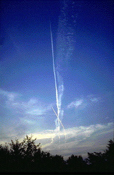
 Photo by Ed Hopkins
Photo by Ed Hopkins
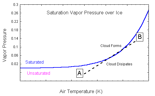
The condensation trail left behind jet aircrafts are called contrails. Contrails form when hot humid air from jet exhaust mixes with environmental air of low vapor pressure and low temperature. The mixing is a result of turbulence generated by the engine exhaust. Cloud formation by a mixing process is similar to the cloud you see when you exhale and "see your breath". The figure below represents how saturation vapor pressure varies as a function of temperature. The blue line is the saturation vapor pressure for ice as a function of temperature (in degrees Kelvin). Air parcels in the region labeled saturated will form a cloud. Imagine two parcels of air, A and B as located on the diagram. Both parcels are unsaturated. If B represents the engine exhaust, then as it mixes with the environment (parcel A) its temperature and corresponding vapor pressure will follow the dotted line. Where this dotted line intersects the blue line is were the parcel becomes saturated.
If you are attentive to contrail formation and duration, you will notice that they can rapidly dissipate or spread horizontally into an extensive thin cirrus layer. How long a contrail remains intact, depends on the humidity structure and winds of the upper troposphere. If the atmosphere is near saturation, the contrail may exist for sometime. On the other hand, if the atmosphere is dry then as the contrail mixes with the environment it dissipates. Contrails are a concern in climate studies as increased jet aircraft traffic may result in an increase in cloud cover. It has been estimated that in certain heavy air-traffic corridors, cloud cover has increased by as much as 20%. An increase in cloud amount changes the region's radiation balance. For example, solar energy reaching the surface may be reduced, resulting in surface cooling. They also reduce the terrestrial energy losses of the planet, resulting in a warming. Jet exhaust also plays a role in modifying the chemistry of the upper troposphere and lower stratosphere. NASA and the DOE are sponsoring a research program to study the impact contrails have on atmospheric chemistry, weather and climate. In this series of satellite images we will investigate the duration of contrails. The satellite images are from the GOES-8 visible channel. Each image is separated in time by approximately 15 minutes. The GOES-8 image has a spatial resolution of approximately 1 km. The satellite image is a view of upper mid-west including southern Wisconsin and northern Illinois. Madison is located on the image. Contrails were observed from the ground during this period. At this wavelength, the GOES-8 imager is measuring the amount of radiant energy reflected by the surface and the clouds. The whiter a given portion of the image, the larger the amount of reflected visible light. White portions of the image represent thick clouds and dark regions are water or heavily vegetated regions. Contrails show up on the image as white streaks, similar to how they appear from a surface view.
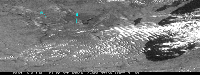 When you view this image of 1846 UTC,
notice the individual contrails labeled A and B.
When you view this image of 1846 UTC,
notice the individual contrails labeled A and B.

In this image 30 minutes later (1902 UTC), both these contrails exist, as well as others.
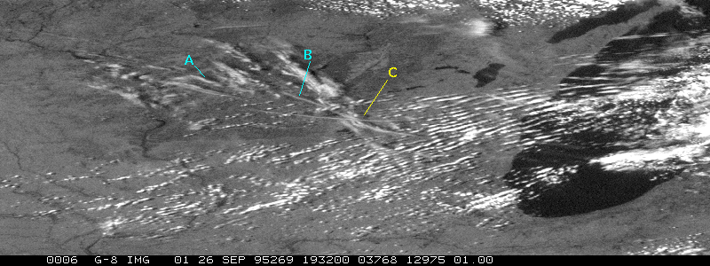
By 1932 UTC, these contrails still exist. Also notice how the contrail labeled C is spreading. Notice also that these clouds are generating shadows. Since we know the position of the sun, we can use these shadows, to calculate the height of the clouds that cast them. A 3 1/2 hour time sequence of the contrails generated on this day.
Contrail left by a shuttle launch.