![]()
Overview of Terra-aqua eXperiment 2002
![]()
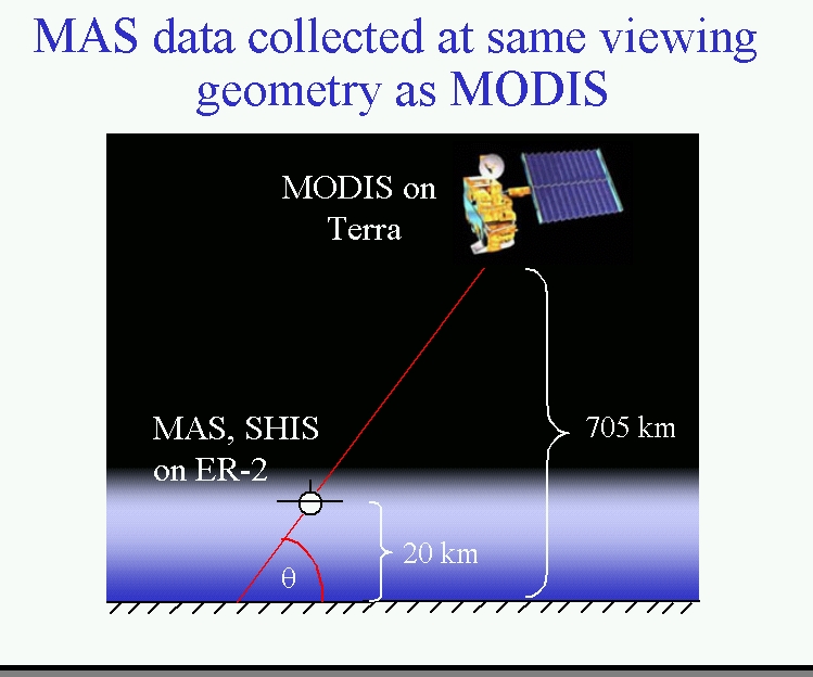
The Terra-aqua eXperiment 2002 (TX-2002) is being conducted from the former Kelly AFB in San Antonio, Texas from November 20 to December 13, 2002 to assess MODerate resolution Imaging Spectroradiometer (MODIS) and Atmospheric Infrared Sounder (AIRS) L1B and science products from the Terra and Aqua satellites. MODIS and AIRS science products including earth-atmosphere radiance, atmospheric profiles (temperature and moisture), cloud top heights, cloud coverage or mask, and cloud particle phase are being collected globally and studied for signatures of Global Climate change under NASA’s Earth Science Enterprise initiative. During the experiment, data will be collected from a NASA high altitude ER-2 aircraft flying at 65000’ with remote sensing instruments looking down at the earth’s atmosphere and surface. The ER-2 will be flown underneath the Terra and Aqua satellites (Figure 1) on each mission, collecting measurements that can be compared directly to the MODIS and AIRS science products. The comparisons will be used to demonstrate the accuracy of the satellite products for usage in monitoring long term Global Climate change as well as suggest ways of fine tuning the MODIS and AIRS science product algorithms. One of the most important unknowns in Global Climate prediction is the percentage and type of cloud cover over the global domain. Warming the earth’s atmosphere is expected to increase its water vapor content, providing more material for the development of clouds (2°C temperature increase translates to 10% more water vapor holding capacity in the atmosphere). This additional water vapor may reside as vapor in the atmosphere (a very effective heat trapping gas), manifest itself as low to mid level water droplet clouds, or be transported by thunderstorms to cold upper atmospheric levels where it will reside as cirrus clouds (ice particles). This is an important consideration as water clouds and ice crystal clouds have very different influences on global climate. Water clouds are very effective sunlight reflectors and are thought to lead to a net cooling effect on the global climate, though this is not proven. Ice clouds meanwhile are thought to be net heat trapping clouds, as most sunlight passes through them downward into the earth-atmosphere system heating the earth. MODIS and AIRS are both designed to provide insight on global cloud and atmospheric water vapor and temperature trends. But before we can confidently interrogate those data sets for global change signatures, the accuracy of the science products must be demonstrated.
The NASA ER-2 (Earth Resources) is a research version of the well known U-2 aircraft and flies above about 95% of the earth's atmosphere, closely emulating satellite based measurements from outer space. During the three weeks of TX-2002, the ER-2 will fly some six to ten missions over the Gulf of Mexico and southern Great Plains, carrying the MODIS Airborne Simulator (MAS), the Scanning High-resolution Interferometer Sounder (S-HIS), the NPOESS Atmospheric Sounder Testbed – Interferometer (NAST-I) and the Cloud Physics Lidar (CPL). The radiometric accuracy of the recently (May 2002) launched Aqua MODIS and AIRS instruments will be evaluated to diagnose any calibration fine tuning needs to mature the thermal infrared (TIR) band observations. Cloud products will be the focus of evaluation for the Terra satellite. An ER-2 experiment called TX-2001 (spring, 2001 also based in San Antonio, TX) was used to evaluate the calibration of MODIS on Terra.; now it’s time to focus on the cloud products from Terra MODIS. The MAS, S-HIS, and NAST-I instruments measure upwelling TIR radiance from the earth-atmosphere system in much the same way that MODIS and AIRS measure the earth-atmosphere system. The MAS instrument provides high spatial resolution (50 m) data for simulating the MODIS 1 km TIR bands. S-HIS and NAST-I provide high spectral resolution data and excellent radiometric accuracy to which MODIS and AIRS TIR band calibration assessments are ultimately pinned. The CPL measurements include cloud parameters such as cloud height, thickness, and cloud particle phase (ice or liquid water); these highly accurate measurements from CPL will be directly compared to similar products from Terra MODIS observations. An important benefit of this activity is that it helps construct the bridge from early years of NOAA/NESDIS satellite observations to the latter day observations of NASA's Terra and Aqua satellites. This importantly helps to extend the data record from years to decades, making the task of uncovering Global Climate change behavior today easier.
TX-2002 is the fourth in an ongoing series of ER-2 field experiments designed in part to assess MODIS and AIRS L1B TIR band calibration and science products. The WISC-T2000 (Madison, WI, March 2000), SAFARI-2000 (Pietersburg, SA, Aug/Sep. 2000), TX-2001 (San Antonio, TX, March 2001) experiment data sets have contributed to the MODIS TIR band calibration assessment. TX-2002 will make a new contribution by assessing the cloud products on Terra MODIS and by assessing the 2nd MODIS and new AIRS instrument calibration on Aqua.
Send corrections or suggestions to: cimssmaster@ssec.wisc.edu