9

Monitoring the Global Environment

GOES-R

The POES Earth Observing Satellite (EOS) Program - I

TERRA

TERRA

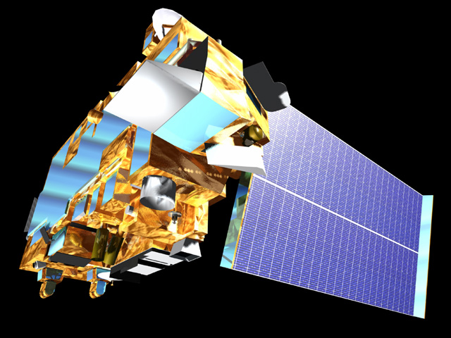
The launch of the Terra satellite marked the beginning of a comprehensive program to monitor solar radiation, the atmosphere, the oceans and continents from a single space-based platform. Terra provides measurements of the global/seasonal distribution of global bio-productivity (land and oceans); land use; land cover, snow and ice; 24-hour global surface temperature; clouds (macrophysics, microphysics, and radiative effects); radiative energy fluxes; aerosol properties and water vapor, fire occurrence, and trace gas levels.

Instruments

There are five instruments on the Terra satellite working together:

Terra and its five instruments
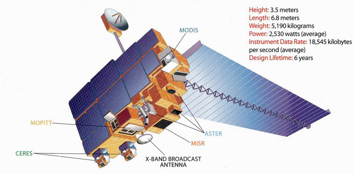
  • ASTER - Advanced Spaceborne Thermal Emission and Reflection Radiometer
  • CERES - Clouds and the Earth's Radiant Energy System
  • MISR - Multi-angle Imaging Spectro-Radiometer
  • MODIS - Moderate-resolution Imaging Spectroradiometer
  • MOPITT - Measurements Of Pollution In the Troposphere
  • ASTER

    Specifications:

    ASTER is the highest spatial resolution instrument on the satellite (15 to 90 square meters) providing images of the Earth in the visible, near-infrared, shortwave-infrared and thermal infrared regions of the electromagnetic spectrum. Due primarily to the high resolution, ASTER is the only Terra instrument that does not acquire data continuously. Scientists can change the data collection configuration from Earth depending upon what their needs are, however, the routine data collection is only 8 minutes each orbit! (Recall that a POES orbit is just under two hours)

    ASTER data products include:

    • High resolution IR and visible images of the Earth's surface;
    • Surface temperatures;
    • Digital elevation maps from stereo images;
    • Surface composition and vegetation maps;
    • Cloud, sea ice, and polar ice products;
    • Observations of natural hazards (volcanoes, land slides, fires, etc... )
  • CERES

    Specifications:

    CERES consists of two scanning radiometers that measure the Earth's radiation balance and provide detailed information on cloud properties. There are two identical CERES radiometers on Aqua & Terra because they operate in different, overlapping scanning modes (crosstrack and biaxial) for more complete data collection.

    Each CERES instrument has three channels- a short wave channel for measuring reflected sunlight, a longwave channel, and a total radiation channel. (0.3 to 200 µmm)

    CERES data will be used to:

    • Study cloud properties;
    • Develop an observational baseline of clear-sky radiation fluxes;
    • Determine radiation input to atmospheric and oceanic models;
    • Validate general circulation models;
    • Enhance extended-range numeral weather predictions for weather forecasting
  • MISR

    Specifications:

    MISR is a new type of instrument designed to gather data about scattered sunlight. This is different from the traditional satellite instrument that looks straight down or toward the edge of the planet. MISR view the Earth with nine different digital cameras pointed at nine different angles. As the instrument flies overhead, each region of the Earth's surface is successively imaged by all nine cameras in four wavelengths (blue, green, red, and near-infrared). In addition to improving our understanding of how sunlight bounces around in the Earth's environment, MISR data can distinguish different types of clouds, aerosol particles, and surfaces.

    MISR monitors monthly, seasonal, and long-term trends in:

    • The amount and type of atmospheric aerosol particles, including those formed by natural sources and by human activities;
    • The amount, types, and heights of clouds;
    • The distribution of land surface cover, including vegetation canopy structure.
  • MODIS

    Specifications:

    MODIS is a scanning imaging radiometer with a viewing swath width of 2330 kilometers. MODIS will provide high-resolution images of daylight-reflected solar radiation and 24 hour thermal (IR) information over all regions of the globe. Its spatial resolution ranges from 250 meters to 1 kilometer. The broadband spectral coverage of the instrument (0.4 to 14.4 µm) is divided into 36 bands of various bandwidths optimized for imaging surface and atmospheric features.

    MODIS measures:

    • Surface temperature (land and ocean) and fire detection;
    • Ocean color (sediment , phytoplankton);
    • Global vegetation maps and change detection;
    • Cloud characteristics;
    • Aerosol concentrations and properties
  • MOPITT

    Specifications:

    MOPITT is a scanning radiometer employing gas correlation spectroscopy to measure upwelling and reflected infrared radiance in two absorption bands of carbon monoxide (2.4 and 4.7 µm) and one absorption band of methane (2.3 µm). Its specific focus is on the distribution, transport, sources, and sinks of carbon monoxide and methane in the troposphere.

    MOPITT data will be used to:

    • Measure and model carbon monoxide and methane concentrations in the troposphere;
    • Obtain carbon monoxide profiles with a resolution of 22 kilometers horizontally and 3 kilometers vertically;
    • Measure the methane column in the troposphere and provide increased knowledge of tropospheric chemistry;
    • Generate global maps of carbon monoxide and methane distribution

"Terra" is the Latin word for land. The EOS AM-1 satellite was given this name because the timing of the orbit flies the satellite over the Earth’s largest land masses (the northern hemisphere) in the morning when cloud cover is at a minimum.