Wind, Swell and Rouge Waves
 The wind not only produces currents, it creates waves. As wind blows across the smooth water surface, the friction or drag between the air and the water tends to stretch the surface. As waves form, the surface becomes rougher and it is easier for the wind to grip the water surface and intensify the waves. The wind not only produces currents, it creates waves. As wind blows across the smooth water surface, the friction or drag between the air and the water tends to stretch the surface. As waves form, the surface becomes rougher and it is easier for the wind to grip the water surface and intensify the waves.
How big wind waves get depends on three things:
- Wind strength. The wind must be moving faster than the wave crests for energy to be transferred.
- Wind duration. Strong wind that does not blow for a long period will not generate large waves.
- Fetch. This is the uninterrupted distance over which the wind blows without significant change in direction.
Storms of equal size can generate much larger waves in the open Pacific Ocean as compared to the other oceans due to the long open distance of water.
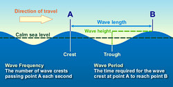
After the wind begins to blow for a while, large waves develop. As the wind continues, the waves get higher from trough to crest, and both the wave length and period become longer. As the wind continues or strengthens, the water first forms whitecaps and eventually the waves start to break. This is referred to as a fully developed sea.
The waves in a fully developed sea outrun the storm that creates them, lengthening and reducing in height in the process. There are called swell waves. Swells organize into groups smooth and regular in appearance. They are able to travel thousands of miles unchanged in height and period.
The longer the wave, the faster it travels. As waves leave a storm area, they tend to sort themselves out with the long ones ahead of the short ones, and the energy is simultaneously spread out over an increasingly larger area. As the waves close in on the coast, they begin to feel the bottom and their direction of travel might change due to the contour of the land. Eventually, the waves run ashore, increasing in height up to 1.5 times their height in deep water, finally breaking up as surf.
There are many sailor tales of "rogue waves", "freak waves", "three sisters" and other "killer waves". Properly called "extreme storm waves" these tales were ridiculed and mariners were accused of using them as an excuse to cover their own mistakes in wrecks.
Most reports of extreme storm waves say they look like "walls of water," and are seen as steep-sided with unusually deep troughs. The USS Ramapo reported one such wave with a height of 112 feet in the Pacific in 1933. Another report of a freak wave occured with it struck the Queen Mary amidships, south of Newfoundland, at the end of World War II, rolling her to within a degree or two of capsizing.
What causes these enormus waves? Generally they form because of swells, while traveling across the ocean, do so at different speeds and directions. As these swells pass through one another their crests, troughs, and lengths happen to coincide and reinforce each other, combining to form unusually large waves that tower then disappear. If the swell are travelling in the same direction, these mountiouns waves may last for several minutes before subsiding.
It is very seldom that huge waves over 65 feet (20 meters) are developed and normally sailors do not even see them, because ships nowadays will try to avoid such conditions by altering course before the storm hits. But they do occur.
|
| Back: Seawater |
|
National Weather Service
Southern Region Headquarters
819 Taylor Street
Fort Worth, Texas 76102 |
www.srh.weather.gov
Updated: March 29, 2006 |
|


