The Gulf Stream
|
|
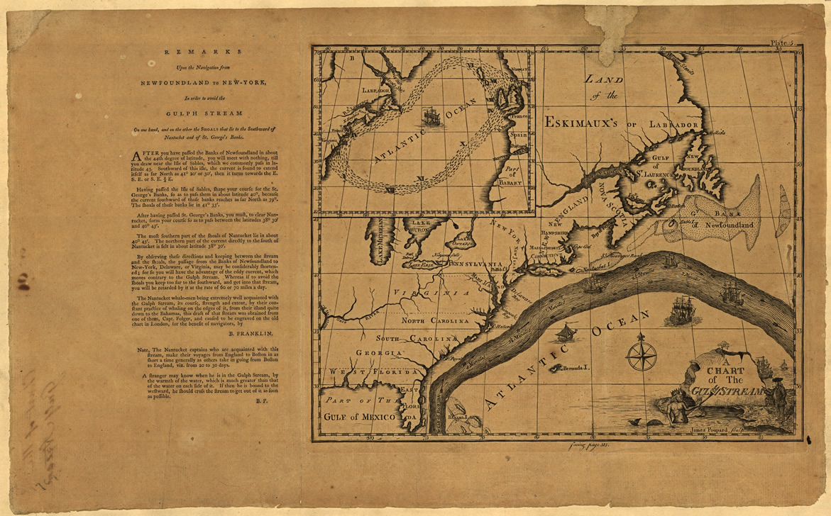
The Gulf Stream is the strongest global ocean current. One of the first people to study and map it was Ben Franklin. He was curious about why trans-Atlantic travel going from North America to Europe was so much faster than the same trip in the opposite direction, from Europe to North America. In his travels across the Atlantic, he measured wind speeds as well as current depth, speed and temperature. Based on his observations, he described the Gulf Stream as a “river of warm water” that flows northward from the West Indies, hugs the east coast of North America and then heads eastward across the Atlantic Ocean to Europe. The figure you see in the upper left is Ben Franklin’s map of the Gulf Stream. He designed it to be useful for commerce and shipping in his time. |
|
To the right is a modern infrared image of sea surface temperatures and a link to a movie of the Florida Current and Gulf Stream made from a sequence of AVHRR imagery. This movie shows the movement of the Gulf Stream over a three year period. It was created from five-day composites of Sea Surface Temperature (SST) measurements acquired by the AVHRR sensor on board NOAA satellite 9, between January 1 st, 1985 and October 25 th, 1988. Each image in the sequence was made by taking the warmest pixel from a 5-day sequence. This was done to reduce contamination of the imagery by clouds, which tend to be cooler than the sea surface. Orange and Red colors mean the SST is warm; blue and green mean a cool SST. On average, the Florida Current hugs the coastline of N. America, following the topography. East of Cape Hatteras North Carolina, the Gulf Stream separates from the coast. As you watch the movie, see if you can observe a couple of phenomena. First, can you observe some places where the Gulf Stream appears to meander, that is, where it shifts position slightly? Now see if you can observe the production of warm core rings. These are chaotic, rotating flows that propagate and briefly persist within the surrounding waters. You might notice some forming during the final third of the movie, near the top of the screen, southeast of the location of Long Island, New York. Certainly, modern remote sensing methods have provided us with powerful tools for viewing and tracking the Gulf Stream, but I think you’ll agree that Ben Franklin’s map compares surprisingly well to the sequence of AVHRR imagery in its ability to locate the Gulf Stream. This is especially impressive in the light of the fact that his observations were made hundreds of years ago and were based on measurements taken aboard ships. | |