Alaska GEOCAT-MODIS Imagery and Products in D-2DInstructions for AWIPS InstallationSpace Science and Engineering Center
|
|
| Project members: Jordan Gerth, Mike Pavolonis (NESDIS), Justin Sieglaff, William Straka | |
Announcements
This data is provided as part of the GOES-R Proving Ground. For assistance and suggestions on obtaining and using the data in AWIPS, please contact Jordan Gerth.
Acquiring Data at an Alaska Region NWSFO
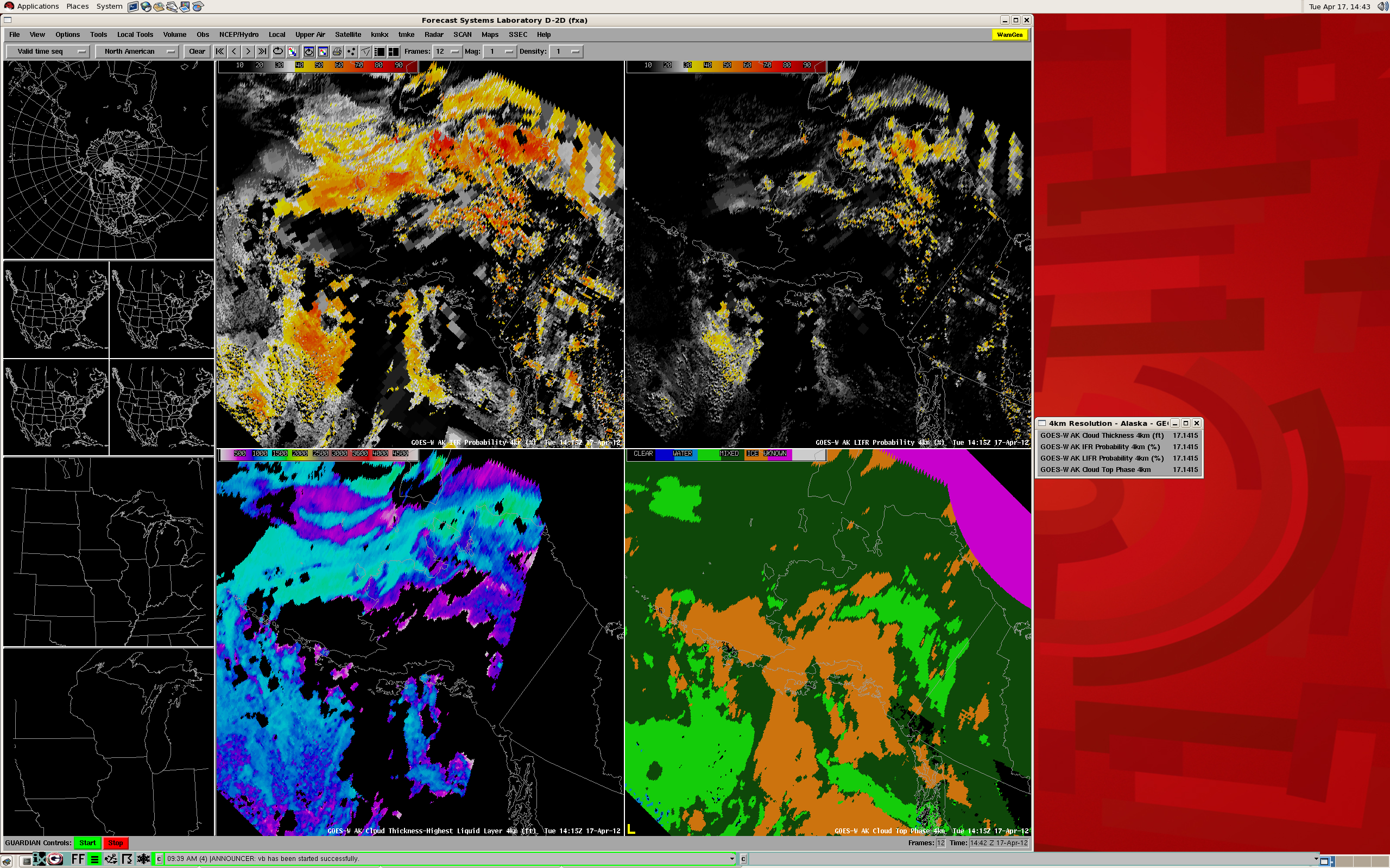
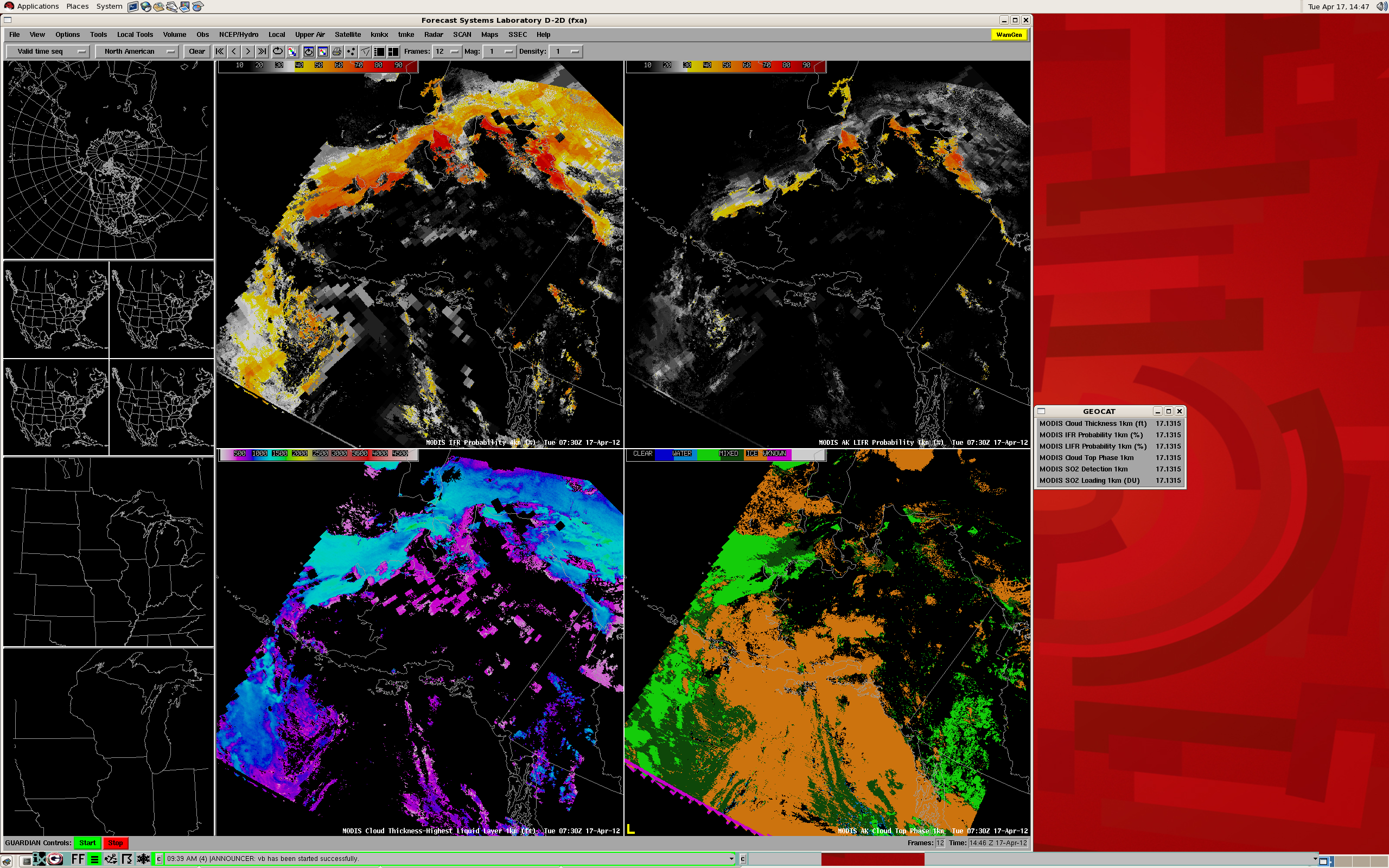
This page contains information for obtaining GEOCAT products for low cloud/fog and volcanic ash forecasting from NASA satellites equipped with a MODerate-resolution Imaging Spectroradiometer (MODIS) for display in AWIPS.
GEOstationary Cloud Algorithm Test-bed (GEOCAT) examples are available.
Data is currently available to Weather Forecast Offices in Alaska Region via GINA. Data is transmitted in compressed netCDF format on the EXP feed of the Local Data Manager (LDM). This is not an operational dataset, so unplanned data errors and outages may result. Contact Jordan Gerth once you are receiving data so we can add your office to the e-mail announcement list. We value any feedback.
The Space Science and Engineering Center is not continuously staffed. Consequently, data outages and processing issues may result. The products should be considered non-operational. Required LDAD/Processing Configurations
Perform the following actions to configure your Local Data Acquisition and Dissemination (LDAD) server.
In /data/fxa/LDAD/data as user ldad on server px2:
- Append to LDADinfo.txt
In /awips/ldad/bin as ldad on px2:
- Add preProcessGEOCAT.pl and assign executable permissions
- Execute "stopLDAD.sh;startLDAD.csh" to restart the LDAD service
In /usr/local/ldm/etc as ldm on ls2:
- Modify ldmd.conf (position sensitive; change upstream.host to your regional LDM server)
- Append to pqact.conf
- Copy ldmd.conf and pqact.conf to ls3 with scp
- Execute "ldmadmin restart" to restart the LDM service
- With "ldmadmin watch -f EXP", watch the LDM queue for GEOCAT data
A zip file of these is available.
Required AWIPS Customizations
Files updated March 2012 — Perform the following actions to configure your Advanced Weather Interactive Processing System (AWIPS) workstations/servers.
Based on instructions.txt, use the two Perl scripts included with color table manipulation package manage-ct.tgz to extract the color tables from the included GeocatColors.nc file and add into /data/fxa/workFiles/customColorMaps.nc. You may wish to use a subset of these color tables as the default enhancement for the GEOCAT products which will be added via localDepictKeys.txt below.
- Download and un-gzip manage-ct.tgz
- Additional instructions about how to use the Perl scripts for adding color tables to your office repository are available
In $FXA_CUSTOM_FILES as fxa (should be mounted on any workstation/server):
- Append to localDataKeys.txt to map product keys to directory locations
- Append to localDepictKeys.txt and modify the 123x color table keys for visualization
- Append to localImageStyle.txt to provide sampling
- Append to localProductButtons.txt to label the menu items
- Append to localPurgeInfo.txt to keep only recent files
- Append to otherSatMenus.txt or dataMenus.txt (see "Known Pitfalls") for selection
A zip file of these is available.
When complete with the changes, run '$FXA_LOCALIZATION_SCRIPTS/mainScript.csh f -tables -dirs' on dx3, then execute '$FXA_LOCALIZATION_SCRIPTS/mainScript.csh f -tables' on all lx and na workstations.
As fxa on dx1, dx2, px1, and px2, perform a '-tables -purge' localization. On dx1, restart the purgeProcess.
As fxa on dx1, restart the notificationServer to complete.
Restart D-2D on the lx/na workstations to access the new products from the satellite menu (or custom menu if dataMenus.txt modified).
Assure your displays match the GOES example and MODIS example.
Required AWIPS II Customizations
These files are subject to change as the software evolves.
In /awips2/edex/data/utility/ as user awips on dx3 or dx4, where LLL is the WFO identifier:
- Add custom cmap (color map) files to edex_static/site/LLL/colormaps
- Append to edex_static/site/LLL/satellite/regionalsat/creatingEntities.xml
- Append to edex_static/site/LLL/satellite/regionalsat/physicalElements.xml
- Append to cave_static/site/LLL/menus/satellite/regionalsat/regionalSatImagery.xml
- Append to cave_static/site/LLL/styleRules/satelliteImageryStyleRules.xml
- If not already done, add menus/satellite/regionalsat/regionalSatImagery.xml to index.xml, the menu contribution file
A zip file of these is available.
Restart EDEX on dx3 and dx4, then restart CAVE on the lx/na workstations to access the new products from the satellite menu.
Known Pitfalls
- The instructions assume local files in $FXA_CUSTOM_FILES do not have the WFO identifier as the first three characters of the file name (LLL-).
- The satellite menu may be too long. This can be fixed.
If you change LLL-otherSatMenus.txt to LLL-dataMenus.txt in
your /data/fxa/customFiles directory, and at the top of that file add
a line such as,

menu:  "Local Sat"

you can move all the CIMSS/SSEC products to their own menu between
Maps and Help.  Then localize with mainScript.csh -tables.
If problems arise — You may need to run dos2unix on some scripts and files.