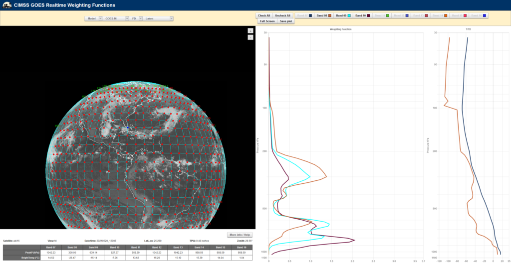
There is a new version of this website.

GOES Weighting Functions Info Page

Question: What's a weighting function?
Technically, it's the change of the total transmittance with respect to pressure. In general, it describes the layer of the atmosphere from which the radiation measured by a particular satellite channel was emitted.
Question: What value for surface emissivity was used in the calculations?
Nothing has been done to account for varying surface types and we use a blanket value of 1.0 (100%) for emissivity in these calculations.
Question: How does view angle affect weighting function calculations?
It depends on the band, please see: this plot to get an idea how how view angle affects forward model calculations. For the bands we're looking at we expect to see brightness temperature decrease with increasing view angle. You can also visit this page to see how weighting functions for the future Imager (ABI) and current Imager vary based on the atmosphere and angle.
Question: What happens to the weighting function calculation if 1 degree is added to the temperature at every level in the atmosphere?
It depends on the band, please see: this PowerPoint Slide to see the calculations. All of the calculations for ABI bands get warmer, most by approximately 1 degree.
Question: What can I tell about the earth's atmosphere from weighting functions?
We encourage you to click around, comparing weighting functions from high altitudes to low altitudes; from cloudy scenes to clear scenes; dry scenes to wet scenes; etc. Pay attention to where the different bands peak during these situations - this may tell you a lot about the amount of water vapor in the atmosphere or where vertically it appears. But this page is also here to debunk some myths about satellite bands, namely that certain bands peak at certain heights in the atmosphere. Where a band peaks is really dependent on the vertical profile and the satellite view angle!
Question: Where is my favorite station? I never see it on your map!
Weighting functions are calculated from RAOB data at the stations shown on the map. If there is a station you would like to see added, which is in the GOES domain, contact us and we'll add it. Rarely there are times when stations don't report; more commonly raob data does not pass quality control and thus a weighting function plot is not made for that time period.
Question: How can the window channel measure 295K when it's cloudy?
GOES Imager and Sounder weighting functions are calculated with a model that assumes clear-sky conditions. This obviously is not always a good assumption; view the calculated brightness temperatures on these plots with some suspicion for cloudy scenes.
Question: Where did those brightness temperatures come from?
Brightness temperatures on the plots are calculated from a forward model, not measured from the satellite.
Question: What are the "Temp Profile" and "Q Profile"?
The "Temp Profile" is the temperature profile from the RAOB and the "Q Profile" is the mixing ratio profile, calculated from the RAOB. Temperature is in degrees Kelvin (K) and mixing ratio units are gram-per-kilogram (g/kg). Users can see how temperature and mixing ratio varied with height for the atmospheric profile used to create the weighting function plot. Mixing ratio is plotted instead of relative humidity for two reasons: that is what is used in the weighting function calculation and because mixing ratio is a more absolute term since relative humidity is also a function of temperature. This feature was added on 19 May 2006 due to user request.
Question: What forward model are you using?
The forward model we use is called the Pressure-Layer Fast Algorithm for Atmospheric Transmittances (Hannon et al. 1996).
Hannon, S., L. L. Strow, and W. W. McMillan, 1996: Amospheric infrared fast transmittance models:
A comparison of two approaches. Proc. Optical Spectroscopic Techniques and Instrumentation
for Atmospheric and Space Research, Denver, CO. Inter. Soc. for Opt. Eng., 94-105.
Question: Does the forward model take into account solar reflection?
No. There is no solar reflection information used in the forward model calculations.
Question: It's 13:00 UTC... where are today's 12:00 UTC weighting functions?
The 00:00 UTC RAOBs are processed at 04:00 UTC and the 12:00 UTC RAOBs are processed at 16:00 UTC. It usually takes about 15 to 20 minutes to get the images made and on the web page.
Question: Can you put the U.S. Standard Atmosphere Weighting Functions out here for us to see?
Yes! In the pulldown menu the U.S. Standard Atmosphere is at the bottom of the list.
Question: What bands are you using? Are you using both the Imager and Sounder?
We use all of the infrared bands from the Imager and the three water vapor bands from the legacy GOES Sounder.