Realtime GOES Sounder Support for IHOP-2002 from
NOAA/NESDIS/ORA/ARAD/ASPT at UW-Madison/CIMSS
** Realtime component was in effect only from 11 April to 25 June 2002. **
To provide current GOES Sounder products
in support
of the IHOP field campaign over the south central US during the spring of 2002,
CIMSS is providing near real-time displays tailored to the IHOP domain.
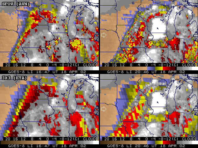
Presentations of the Derived Product Images (DPI) of profile parameters in clear air, such as, total precipitable water (PW in [mm]), lifted index stability (LI in [C]), and surface skin temperature (SKT in [C]), show hourly imagery over the last six hours.
"Pseudo DPI" are also available, for Convective Available Potential Energy (CAPE) and Convective Inhibition (CIN), where an image is created from retrieval profiles, "after the fact".
In addition, cloud top pressure (CTP in [hPa]) DPI are also provided.
All these PW, LI, CAPE, CIN, CTP, or SKT DPI can be animated (for trends) or toggled (for intercomparisons). Comparisons with other estimates include the first-guess PW field (from interpolated AVN model forecasts and surface reports), the Eta model Lifted Index forecasts, and the 00 and 12 UT radiosonde PW and LI values.
The gif files (and associated animations) of GOES Sounder DPI from previous days remain accessible through the web, stored by their date (yyddd) and labelled with a parameter/date/time name.
[For example: a "yyddd" of 02121 is, for year (20)02, the 121st day of that year, which is 01 May 2002.]
The IHOP coordinators maintain a catalog of the daily summary reports of missions and various field operations.
Note: Preliminary products from GOES-11 were also available for a couple weeks (03-21 June 2002). GOES-11 is at 101 W (GOES-8, at 75W). GOES-11 Sounder radiometric performance is superior to that of the older GOES-8. Some fine adjustment of GOES-11 processing may still be required. Look within the archive of previous days for available comparisons with GOES-11 and -8 data.
(Unless otherwise indicated, any product would default to being from the "operational" GOES-8 data.)
Until recently here at CIMSS, these GOES Sounder DPI had traditionally been generated with 3x3 FOV (field-of-view)
spatial resolution .
However now, since 22 March 2002, single FOV (SFOV) resolution retrieval processing is now done, which is approximately at 12 km east-west and 15 km north-south spacing in this region, focussing on Kansas, Oklahoma, and the Texas Panhandle for the IHOP experiment.
Disclaimer. The products from GOES or other satellites shown here
are experimental. These have been generated within a research
environment and are not intended to be considered operational. Timeliness,
availability, and accuracy are sought but not guaranteed.
Return to CIMSS (UW-Madison) or
ASPT (NOAA/NESDIS/ORA).
Last update was 26 Jun 2002. Feedback.