GOES-8 sounder for BAND 8 (11 micrometers)
|
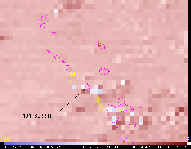
For more information about a pixel to the west and east of the Island of Monserrat:
LA 9007
  area  ss  yyddd hhmmss  lcor  ecor lr er zr  lsiz  esiz z    bands
  ---- ---- ----- ------ ----- ----- -- -- -- ----- ----- -    -----
  9007  71  97218 192000  5401  8931 10 10 19   160   288 2 123456789ABCDEFG
LA: Done

NOTE        := AT THE POINT *WEST* OF THE ISLAND

NOTE        := SCALED (x100) RADIANCES:
GIMD R
   LINE   ELEM    LAT    LON   LZEN   SZEN   ELEV   SURF    VIS
   6436   9945   1672   6249   2426   4755      0      0     13
  CHAN1  CHAN2  CHAN3  CHAN4  CHAN5  CHAN6  CHAN7  CHAN8  CHAN9
   4099   3830   6039   7567   8386   9543   9478   8044   4220
  CHA10  CHA11  CHA12  CHA13  CHA14  CHA15  CHA16  CHA17  CHA18
   1836   1100    358  14760   7942   1884  10559  12677  11009

NOTE        := SCALED (x100) BRIGHTNESS TEMPERATURES:
GIMD
   LINE   ELEM    LAT    LON   LZEN   SZEN   ELEV   SURF    VIS
   6436   9945   1672   6249   2426   4755      0      0     13
  CHAN1  CHAN2  CHAN3  CHAN4  CHAN5  CHAN6  CHAN7  CHAN8  CHAN9
  21626  21476  23938  25451  26234  27488  27838  27678  25835
  CHA10  CHA11  CHA12  CHA13  CHA14  CHA15  CHA16  CHA17  CHA18
  26208  25425  23505  27719  26486  23977  29071  30317  31345


NOTE        := AT THE POINT *EAST* OF THE ISLAND

NOTE        := SCALED (x100) RADIANCES:
GIMD R
   LINE   ELEM    LAT    LON   LZEN   SZEN   ELEV   SURF    VIS
   6445  10005   1664   6191   2459   4824      0      0     12
  CHAN1  CHAN2  CHAN3  CHAN4  CHAN5  CHAN6  CHAN7  CHAN8  CHAN9
   4495   3958   4939   5865   6286   7115   7279   5915   3020
  CHA10  CHA11  CHA12  CHA13  CHA14  CHA15  CHA16  CHA17  CHA18
   1230    702    234  10908   6197   1613   6436   6526   5038

NOTE        := SCALED (x100) BRIGHTNESS TEMPERATURES:
GIMD
   LINE   ELEM    LAT    LON   LZEN   SZEN   ELEV   SURF    VIS
   6445  10005   1664   6191   2459   4824      0      0     12
  CHAN1  CHAN2  CHAN3  CHAN4  CHAN5  CHAN6  CHAN7  CHAN8  CHAN9
  22070  21628  22876  23996  24534  25690  26240  25995  24415
  CHA10  CHA11  CHA12  CHA13  CHA14  CHA15  CHA16  CHA17  CHA18
  24854  24080  22485  26999  25949  23704  27918  28715  29460

LZEN is the local zenith angle, SZEN is the solar zenith angle
ELEV is the surface elevation (m),  SURF is surface type (0=ocean)
time, dwell, step, dect, sat:   193412     1     0     4     8