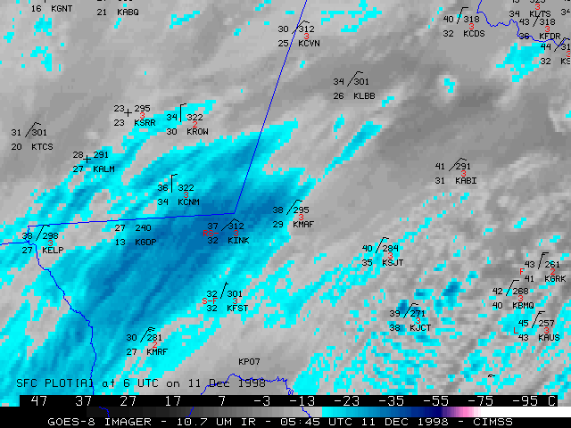
11 December 1998 -- GOES-8 10.7 Micron Longwave IR
Heavy Snow Over Southwest Texas
(this 25-image Java animation sequence will take a minute or two to load...)
(this 25-image Java animation sequence will take a minute or two to load...)
This loop of GOES-8 10.7 micron longwave IR imagery shows the development of a southwest-northeast oriented band of cold cloud tops (-17 to -35 C, light blue to dark blue enhancement) across southwest Texas and southeast New Mexico on 11 December 1998. Heavy snow developed along and just to the north of the southern edge of this cold cloud band, with a record-setting 9.75 inches falling at Midland, TX (station identifier KMAF). The southern edge of the cold cloud band corresponded to the zone of enhanced upward vertical motion within a middle to upper level cyclonic shear zone that was moving slowly across the region that day.
Also evident in the later portion of the loop is a series of elongated convective cloud bands that develop between Midland (KMAF) and San Angelo (KSJT), and then feed northwestward into the southern edge of the main cold cloud band. These convective features enhanced showfall rates in the region between Midland , San Angelo and Abilene (KABI).
Hourly surface reports are also plotted on the imagery, with precipitation reports in red (R = rain; S = snow; IP = ice pellets (sleet); L = drizzle).
