|
|
|
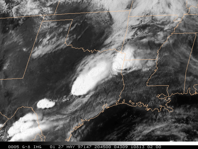
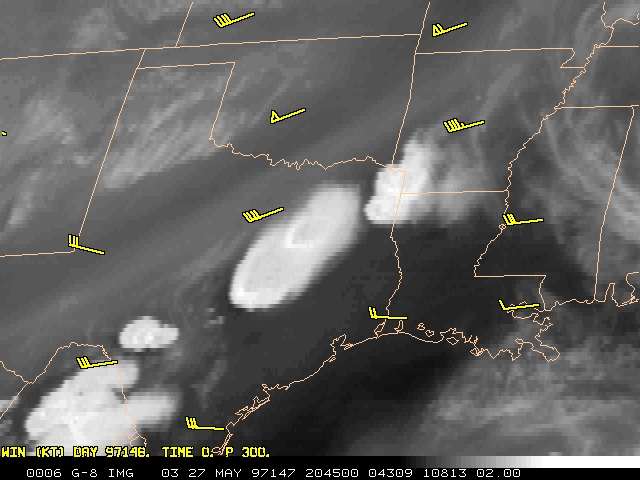
On the afternoon of Tuesday 27 May 1997, deadly tornadoes struck in Texas, with a particularly strong tornado hitting Jarrell (latitude 30:50 N, longitude 97:36 W, between Austin and Waco) about 4 PM CDT (2100 UTC). A cold front, extending between Texarkana to the northeast and the Big Bend region to the southwest, had been slowly progressing to the southeast across Texas during the day. A GOES-8 Imager visible picture at 2045 UTC clearly shows several large thunderstorms which were developing along the front, including the impressive cell over Jarrell. The airmass on the southeast side of the front was warm and moist. At upper levels, the wind flow was rather modest, with later 0000 UTC radiosonde wind speeds at 300 mb (hPa) only measured at 30 to 50 kts (15 to 25 mps) across the region. A distinctive "dry slot", often indicative of strong synoptic dynamics aloft, was not apparent in the GOES-8 Imager upper level water vapor imagery (6.7 micrometer band).
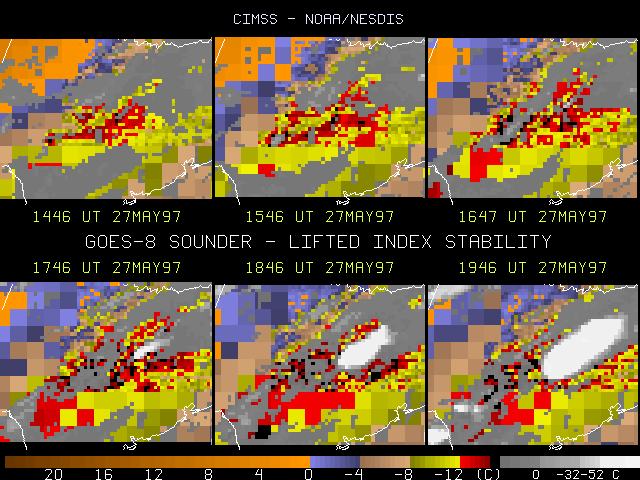
Hourly Derived Product Images (DPI) from the GOES-8 Sounder were generated in near real-time at CIMSS and were available on the Realtime GOES section of the CIMSS Homepage. Very unstable conditions were shown in the lifted index (LI) parameter DPI over east central Texas on the 27th. The images displayed run from 1446 through 1946 UTC. The color enhancement has been modified from that routinely used on the CIMSS Realtime GOES page to emphasize the most unstable portion of the data. Note the persistent and very unstable region (red indicates LI values of -12 to -14 C, while black pixels denote an extremely unstable LI value of -15 C) in the center of each frame, highlighted by the developing storm over Jarrell.
These DPI are generated by a physical retrieval algorithm, where the cloud cleared radiance measurements from the 18 Sounder bands are used to adjust first guess atmospheric profiles. The nominal Sounder field of view (FOV) is 10 km. Unfortunately, computer resource constraints have forced routine production of two resolutions of the DPI output. Along the west and south portions of each frame, the DPI are generated only for 5x5 FOV boxes, while the rest of the region is covered by single FOV resolution. Some cloud edge contamination may be present, but sufficient coverage for very unstable values (red) builds confidence in the satellite pattern.
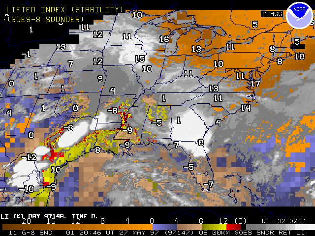
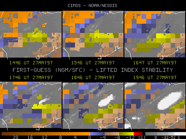
Later radiosonde values at 0000 UTC support the reasonableness of the GOES products, with generally very unstable LI values from -8 to -12 on the warm (Gulf) side of the frontal system. (Note that the Corpus Christi profile (+10) is in error.) Comparison with the first guess LI fields shows a similar region for the most unstable area, but with less magnitude. At 1746 UTC, the first guess indicated -11 C for the LI, while the GOES estimate was -14 to -15 C (for the most unstable boxes in the first guess). The first guess product is a blending of the most recent surface hourly data and a time interpolated 12 to 18 hour NGM (NCEP Nested Grid Model) forecast. This smaller scale look at the GOES LI field in the DPI image format is in good agreement with the presentation of the GOES LI pattern from the NOAA/NESDIS/FPDT-produced retrieval data set, as presented by D. Gray (FPDT). [See http://orbit7i.nesdis.noaa.gov:8080/jarrell.html ]
In conclusion, the frequent GOES LI data clearly depicted the most consistent and rather impressive axis of atmospheric instability to be in east central Texas along which significant severe convection developed. This region is notably void of upper air stations, in both space and time.