
|

|

|
|
|
|
|
This is an unusual example demonstrating detection of surface-based features on the GOES imager water vapor channel data. The map overlay has been removed on the animations of GOES-12 6.5 micrometer ("water vapor channel") imagery to allow you to distinctly pick out the land-water boundary across the entire northern periphery of the Great Lakes region on 13 January, and later the coast of New England on 14 January 2004.
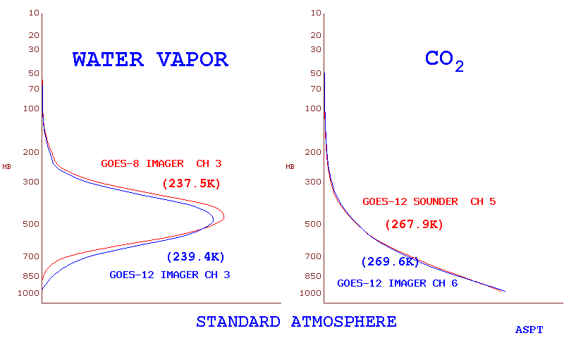
The GOES imager water vapor channel "weighting function" normally peaks in the 400-500 hPa layer (calculated using the US Standard Atmosphere), telling us that most of the radiation sensed by this channel primarily originates in the middle to upper troposphere. The arctic air mass occupying southern Canada and the northern Great Lakes region on this day was so cold and dry (Pickle Lake, Ontario rawinsonde data indicated a total column precipitable water of 0.6 mm / 0.02 inch; mean boundary layer mixing ratio less than 0.2 g kg-1) that significant amounts of radiation from the warm lake water below is "bleeding up" through what little mid-tropospheric moisture signal is present, allowing us to see radiation originating from surfaced-based features -- in this case, the strong thermal gradient between the very cold land surface in southern Canada and the still-unfrozen (and cloud-free) warm water along the northern portion of the Great Lakes (Aqua MODIS visible image | IR image). Note the bi-modal and tri-modal features on the water vapor channel weighting function curves generated using the cold, dry airmass profiles upstream of the Great Lakes region (The Pas, Manitoba and Pickle Lake, Ontario) -- these plots suggest that there is a significant contribution from radiation originating at or below 700 hPa in these cold, dry air masses.
Several hours later, as the cold dry air mass moved eastward, the coast of Maine, Cape Cod, and the Saint Lawrence were apparent in the GOES-12 imager water vapor channel data. While not as cold and dry as the Canadian profiles, the Albany NY rawinsonde report did indicate a total column precipitable water value of only 2.1 mm, with a mean boundary layer mixing ratio of 0.8 g kg-1. The water vapor weighting function profile peaked at a reletively low level (650 hPa) for this air mass, with a significant contribution from radiation originating in the 850-700 hPa layer.

|

|

|

