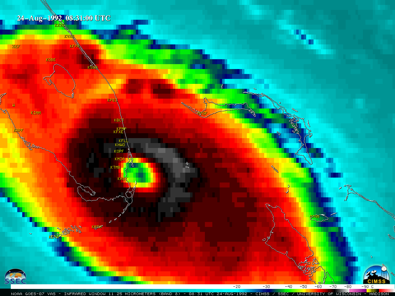
50th Anniversary of the first TIROS-1 satellite image

April 1st, 2010
First TIROS-1 image (01 April 1960)

First TIROS-1 image (01 April 1960)

Today marks the 50th anniversary of the first image from the meteorological satellite TIROS-1, which was available on 01 April 1960 (above). While TIROS-1 was only operational for 78 days, it provided a number of images of the Earth and cloud systems (including the first image of a tropical cyclone, over the South Pacific Ocean on 10 April 1960).

To demonstrate how satellite imagery has improved over the past 50 years, one only has to examine McIDAS images of NOAA GOES-13 visible channel data (below) over the same general region as shown on the first TIROS-1 image (Maine, and the Canadian Maritime provinces). While swirling high-level clouds occupy most of the satellite scene on 01 April 2010, you can still see very good details of low cloud features, such as the stratus deck beginning to erode over parts of Maine and New Hampshire. One particular feature of interest is the bright white snow-covered peak of Mount Katahdin in north-central Maine (which remains stationary in the images, as the clouds around it erode) — this geographic feature has a peak elevation of 5,268 ft (1,605.7 m), and marks the northern point of the Appalachian Trail. Also, if you look closely, you can also see a small ice floe moving slowly westward across open waters of the Gulf of Saint Lawrence, just south of the coast of Quebec (near the upper right corner of the images)sea ice in the Gulf of Saint Lawrence was also seen in some of the earliest TIROS-1 images.

Note that GOES-13 will replace GOES-12 as the operational GOES-East satellite on 14 April 2010.

GOES-13 visible images (01 April 2010)

GOES-13 visible images (01 April 2010)

Polar orbiting (POES) satellite imagery has also improved dramatically, as can be seen on a NOAA-17 AVHRR false color Red/Green/Blue (RGB) image (using AVHRR channels 01/02/04) centered over Maine on 01 April 2010 (below). Again, note the brighter white snow-covered peak of Mount Katahdin, located to the northwest of Millinocket (station identifier KMLT). The widespread low clouds appear brighter white on the false color image, while high cirrus clouds in the northwestern corner of the image take on more of a light blue tint. Bare (snow-free) ground in southwestern Maine appears as shades of green.

NOAA-17 AVHRR false color RGB image (01 April 2010)

NOAA-17 AVHRR false color RGB image (01 April 2010)

Halloween Blizzard of 1991

October 29th, 2009

HallowLoop

The Halloween Blizzard of 1991 was an early-season storm that moved north from the Gulf of Mexico to the upper Great Lakes. Unseasonably cold air allowed the rich moisture-laden airmass to deposit a long band of snow from the Panhandle of Texas northeastward to western Lake Superior. Many early-season snow total records were broken, and single-storm records fell at Minneapolis (28.4″) and Duluth (36.9″) Typically storms from the Gulf of Mexico do not move due north; however, eastward motion of this system was blocked by a large nor’easter off the coast of New England (the so-called “Perfect Storm”).

In the visible loop above, notice the rapid melting of snow deposited by the system in west-central Texas, despite record cold (30 and 31 October 1991 are the only October days in Amarillo history that stayed below 30 all day) Snowcover in South Dakota (The Missouri River stands out) also speaks to the chill in the airmass on the cold side of the storm.

(Coming soon: Infrared and Water Vapor imagery of this storm)