The urban heat island effect is a well-documented example of inadvertent modification of climate by human activities in the form of increased temperatures of urban areas compared to a city’s rural surroundings. It is a fine example of how changing the energy balance of a region can affect the regional climate.
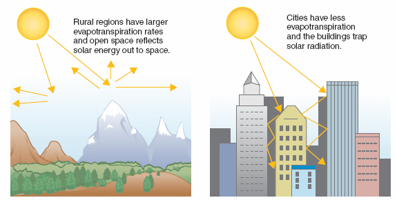
On average, the city is warmer than the countryside because of differences between the energy gains and losses of each region. There are a number of factors that contribute to the relative warmth of cities, such as heat from industrial activity, the thermal properties of buildings, and the evaporation of water. For example, the heat produced by heating and cooling city buildings and running planes, trains, buses, and automobiles contributes to the warmer city temperatures. Heat generated by these objects eventually makes its way into the atmosphere, adding as much as one third of the heat received from solar energy. The architecture of cities intensifies UHI effect. The canyon shape of the tall buildings and the narrow space between them magnifies the longwave energy gains. During the day, solar energy is trapped by multiple reflections off the many closely spaced, tall buildings, reducing heat losses by longwave radiation (See schematic below). Pollution in the city’s air also modifies the absorption of longwave and shortwave radiation of the atmosphere.
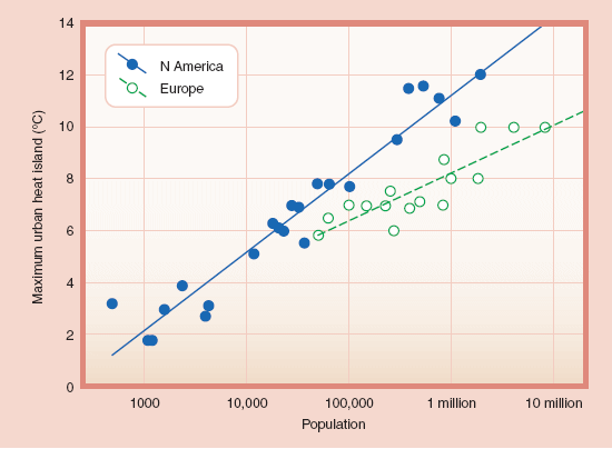
The figure below shows the magnitude of the urban heat island as a temperature difference between a city and its surroundings, for clear sky and light wind conditions, plotted as a function of city population. The different slopes of the relationship differ for cities in different parts of the world. This difference results from differences in the urban characteristics, the characteristics of the rural surroundings, and the prevailing climate. More typically, heat island intensities are in the range of 1° C to 3° C (2° F to 5° F) degrees, even for large cities, indicating the importance of wind and cloud effects. Seasonally, heat islands in temperate climates are a maximum during summer and fall when weather conditions are more favorable.
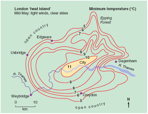
The intensity of the heating varies across a city, with the highest temperatures found near the city core. For instance, under clear skies and light winds, temperatures in central London (see figure below) during the spring reached a minimum of 11° C (52° F), whereas in the suburbs they dropped to 5° C (41° F), a difference of 6° C (11° F).
We can reduce the magnitude of the urban heat island through various mitigation strategies. Examples include planting trees and vegetation to shade the surface and provide evaporation cooling and increasing the reflectivity of surfaces such as roofs to reduce the amount of solar radiation absorbed.