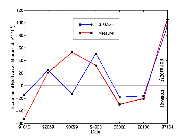
 This figure shows the incremental change in mud area at the Chenier Plain
from year to year (1991 - 1997). Values above (below) the zero-line
indicate accretion (erosion) from the previous year's measurement.
The red line
indicates actual geomorphic
measurements made
from aerial photography. The blue
line indicates the modeled
geomorphic estimates
made using a combination of wind energy
measurements and water level measurements from within Atchafalaya Bay.
Note the large amount of accretion from 1996 to 1997. The photography
from 1997 showed the largest mud flat at the Chenier Plain seen since measurements
began a decade ago.
This figure shows the incremental change in mud area at the Chenier Plain
from year to year (1991 - 1997). Values above (below) the zero-line
indicate accretion (erosion) from the previous year's measurement.
The red line
indicates actual geomorphic
measurements made
from aerial photography. The blue
line indicates the modeled
geomorphic estimates
made using a combination of wind energy
measurements and water level measurements from within Atchafalaya Bay.
Note the large amount of accretion from 1996 to 1997. The photography
from 1997 showed the largest mud flat at the Chenier Plain seen since measurements
began a decade ago.
Back to Data
Products
NOTICE: The photographs, images, text, graphs, and
other information on these web pages are proprietary information belonging
to The Cooperative Institute for Meteorological Satellite Studies (CIMSS)
at the University of Wisconsin-Madison. If the information
is of use to you, please give proper credit to CIMSS. Thanks!
Got questions or comments about this page?
E-Mail Contact Form
Last updated May 18, 1998