

Products/Data - Convective Signature
In order to provide nowcasts of convective initiation (CI) using satellite-derived pre-CI indicators, a scoring system has been developed that incorporates eight IR interest fields as a simple sum of positive indicators for the occurrence of CI. It is important to note that each IR-based CI interest field used in the scoring is related to the physics of cloud growth and glaciation related to precipitation formation in cumuliform clouds, and thus describes the time-evolution of the CI process from an IR perspective. A summary of the criteria incorporated into this scoring system is presented below in Table 1.
| CI Interest Field | Critical Value |
|---|---|
| 10.7 µm TB (1 score) | < 0° C |
| 10.7 µm TB Time Trend (2 score) | < -4° C/15 mins ΔTB/30 mins < ΔTB/15 mins |
| Timing of 10.7 µm TB drop below 0° C (1 score) | Within previous 30 mins |
| 6.5 (or 6.7) - 10.7 µm difference (1 score) | -35° C to -10° C |
| 13.3 - 10.7 µm difference (1 score) | -25° C to -5° C |
| 6.5 - 10.7 µm Time Trend (1 score) | > 3° C/15 mins |
| 13.3 - 10.7 µm Time Trend (1 score) | > 3° C/15 mins |
These eight IR interest fields (out of the 14 possible IR fields, see Table 2 below) were chosen because they are believed to contain unique information for CI nowcasting. For CI nowcasting applications, the GOES-12 Imager 4-8 km IR data are interpolated to the 1 km VIS resolution. By doing this, the IR analysis techniques can be directly combined with the 1 km VIS data in ways that preserve the high detail and value that the VIS data (i.e. convective cloud mask) provides to the CI nowcast problem. The critical values for each IR interest field were obtained from published satellite-based CI studies and a comparison of IR satellite imagery to WSR-88D radar reflectivity for many convective storm events to identify TB and multi-spectral difference thresholds present before precipitation was detected from convective clouds. One point (score) is assigned to each pixel when a CI interest field criterion is met. Satellite pixels that meet at least 7 of 8 CI criteria have been determined to represent rapidly growing, immature (non-precipitating) cumulus in a pre-CI state. The underlying assumption in this nowcasting system is that immature cumulus exhibiting recent signs of rapid development will continue to evolve into robust precipitating convective storms, provided that the cloud has access to a sufficient ABL/elevated moisture source.
| GOES-12 Derived Field | Contribution | Uniqueness |
|---|---|---|
| Visible Brightness Counts | Convective Cloud Mask | Unique |
| 10.7 µm TB | Convective cloud mask and cloud-top temperature assessment | Unique |
| 3.9, 6.7, 13.3 µm TB | Redundant | |
| 3.9-10.7 µm Difference | Cloud-top microphysical assessment. (Not used due to effect of reflected shortwave radiation on 3.9 µm TB) |
Not Used |
| 6.5-10.7 µm Difference | Cloud-top height relative to tropopause | Unique |
| 13.3-10.7 µm Difference | Cloud-top height changes | Unique |
| 10.7 µm Temporal Trend | Cloud-top cooling rates | Unique |
| 3.9, 6.5, 13.3 µm Temporal Trend | Redundant | |
| 3.9-10.7 µm Temporal Trend | Time changes in cloud-top microphysics | Not Used |
| 6.5-10.7 µm Temporal Trend | Time changes in cloud height relative to the tropopause | Unique |
| 13.3-10.7 µm Temporal Trend | Time changes in cloud top height | Unique |
| Visible and Infrared Winds | Cumulus cloud tracking for temporal trend assessment | Unique |
Convective clouds highlighted by this product exhibit sufficient cloud-top TB’s/growth rates and thus should be monitored for future CI. In several convective events, this product has demonstrated CI nowcasting skill up to a 45-minute lead time. An example of this product and the associated radar imagery are provided in Figures 1 and 2. Being that this product only incorporates satellite based CI indicators and does not infuse any real-time boundary layer thermodynamic/kineamatic information, the value of this product is maximized when combined with other information such as boundary layer temperature/moisture analyses and mesoscale boundary (e.g. thunderstorm outflow, sea-breeze fronts, dry-lines) identification in an expert system such as the NCAR AutoNowcaster.
This product is currently produced at 00 and 30 minutes of each hour during daylight hours. Quicklook images of the CI nowcasting product and other CI-related products can be found at http://biscayne.ssec.wisc.edu/~johnm/CI_home/.
CI interest fields and CI nowcasts can be found on the UW-CIMSS ftp server
at:
ftp://ftp.ssec.wisc.edu/asap/products/convective_signatures/
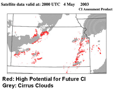
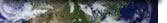
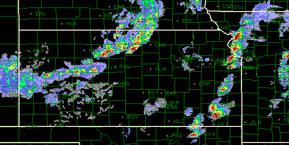
Figure 1: The CI nowcast product valid at 20:00 UTC on 4 May 2003. Pixels
highlighted in red have met at least 7 of 8 CI criteria and need to be monitored
for future CI over the following 30-45 minutes. Grey pixels represent mature
cumulus and cirrus from the convective cloud mask.
![]()
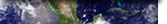
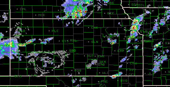
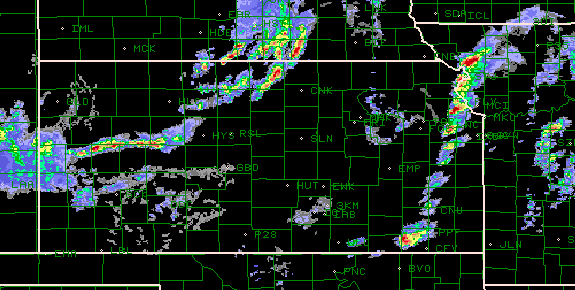
Figure 2. Radar imagery from 4 May 2003 over the same region as Figure 1
at 2000 UTC (top), 2030 UTC (middle), and 2100 UTC (bottom). (images courtesy
of NCAR-RAP)