


Products/Data - Convective Cloud Mask
A combination of four techniques are used to identify convective clouds in GOES-12 geostationary satellite imagery: 1) a "brightness gradient" technique for preliminary identification of immature, non-precipitating cumulus, 2) a "brightness threshold" technique for preliminary identification of mature cumulus, which could be precipitating, 3) 10.7 µm TB and IR spectral band differencing thresholds to separate immature cumulus that meet the "brightness threshold" criterion but are improperly classified as mature, and 4) a textural analysis of visible brightness values to separate low, thick stratus clouds from the mature cumulus classification. Figure 1 provides a flowchart that demonstrates the processing required to produce the convective cloud mask. The convective cloud mask is not only important for informing the aviation community on the location of convective clouds but also is the first step in the development of a convective storm initiation (CI) and development nowcasting system. We use the convective mask to calculate IR-based CI interest fields only where cumulus are present, thereby excluding approximately 80% (on average) of a given satellite image. This process saves a great amount of computing time, allowing the CI nowcasts over large geographical regions in real-time.

Figure 1 (Larger version available)
The first step in the development of the convective cloud mask is to minimize satellite "noise," correct for bad scan lines, and sharpen cloud edges using a shot noise filter provided by the McIDAS software. The next step is to interpolate the 4-8 km IR data to the 1 km visible resolution. This process allows us to combine both IR and visible analysis techniques to identify convective clouds. In addition, this process also preserves the high detail that the 1 km visible resolution provides.
The next step is to identify immature, non-precipitating cumulus clouds using a "brightness gradient" technique. A unique attribute of cumulus clouds in satellite imagery is their bright distinct edges (in terms of visible brightness counts). In order to find these sharp edges, we calculate horizontal gradients of satellite-detected brightness. Horizontal gradients larger than well-tested threshold indicate the presence of a cumulus cloud edge, where a transition from a dark, cloud-free pixel to a bright, cumulus cloud pixel has been found. This technique only identifies cumulus cloud edges, thereby giving immature cumulus a "ring-like" appearance. This problem is corrected by also classifying pixels in the middle of these "rings" as cumulus.
The next step is to identify mature cumulus and their associated cirrus anvils using a "brightness thresholding" technique. In most cases, these clouds are the brightest of all features in visible satellite imagery due to their microphysical composition of small, supercooled water droplets/ice crystals. We utilize this attribute by finding clouds with brightness greater than a time-of-day and time-of-year dependent brightness threshold. We set this threshold quite high so that we can identify cumulonimbus and thick cirrus anvil clouds.
Unfortunately, the "brightness threshold" technique occasionally misclassifies bright, immature cumulus and thick stratus clouds as mature cumulus near solar noon, as the maximum amount of solar radiation is reflected and detected by the GOES visible sensor. As a final step in the convective cloud mask, we invoke a set of quality-control checks to address these problems.
A -20 °C 10.7 µm temperature (IR) threshold, described by Roberts and Rutledge (Weather and Forecasting, 2003), is used to better separate immature from mature cumulus and cirrus. Roberts and Rutledge (2003) noted that monitoring the IR temperature drop from 0 to -20 °C, in addition to the temporal trends in IR temperature, can provide up to 30 min. advance notice of CI (> 35 dBz radar reflectivities). It is assumed that cumulus which meet the brightness threshold criterion and have IR temperatures > -20 °C have not begun to precipitate and are still immature.
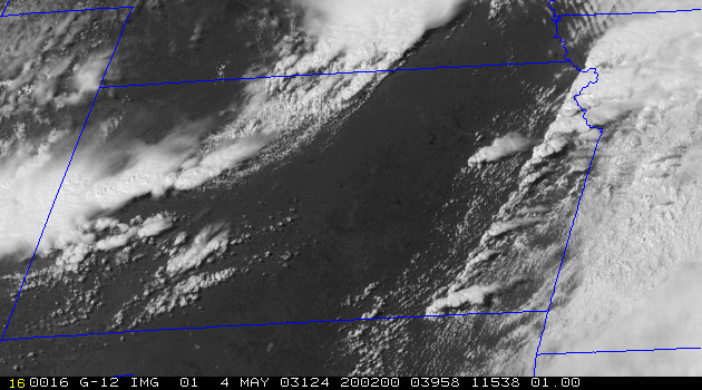
The standard deviation of brightness is calculated over a 5x5 pixel box (25 km2), centered at each previously classified cumulus cloud, in order to separate highly reflective stratus/cirrus cloud from mature cumulus. Another unique aspect of cumulus clouds in the visible satellite is their "lumpy" appearance. Statistically, this "lumpiness" can be identified by high standard deviations in brightness within the 5x5 box. Thus, clouds with high standard deviations retain their cumulus classification. Clouds with low-standard deviations, 10.7 µm TB < -20 °C, and 6.5-10.7 µm differences > -10 °C are retained as cirrus clouds. Other pixels that were previously identified as mature cumulus with 10.7 µm TB > -20° C are removed, being that they likely represent highly reflective stratus clouds. An example of this product is provided in Figure 2.
 |
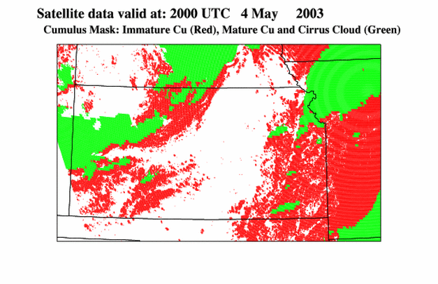 |
Figure 2 (click on images for larger versions)
This product will be available over a limited CONUS domain twice per hour during the daylight hours on the UW-CIMSS ftp server at:
ftp://ftp.ssec.wisc.edu/asap/products/convective_mask/
Cloud mask values of 1 indicate the presence of immature cumulus and values
of 2 indicate mature cumulus or cirrus clouds. A value of –9999 indicates
that no convective cloud is present.