STATION WEATHER PLOTS
Satellite images, fronts, isobars, highs and lows show large scale weather features and help us see the big weather picture. However, lots of people like meteorologists and pilots need to look at weather data in more detail. One common way to look closer at the weather conditions is with station weather plots. The station weather plot shows the current weather conditions, cloud cover, wind speed, wind direction, visibility, temperature, dew point temperature, atmospheric pressure, and the change in pressure over the last three hours. (that's a lot of information!)
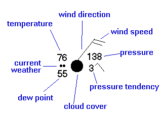
Here is an example of a surface station weather plot (in black) with labels explaining the data ( in blue).
In this station plot, the temperature is 76 degrees Fahrenheit (F), the dew point is 55F, the wind direction is from the northeast at about 20 knots. The pressure is 1013.8 mb (millibars). The pressure tendency indicates that the pressure increased then decreased and is now lower by 0.3 mb than three hours ago. The cloud cover is overcast and it is raining. The amount of sky covered by cloud is indicated by the circle in the center of the station plot. Whatever fraction is filled in represents the fraction of the sky that is cloudy for that location.Here are some Weather Symbols

Smoke 
Haze 
Dust 
Blowing Snow 
Lightning 
Funnel Cloud 
Light Fog 
Thick Fog Precipitation at time of observations
Type Light Moderate Heavy Drizzle Rain Snow Other types of precipitation
Rain Shower Snow Shower Thunderstorm Freezing drizzle Freezing rain Sleet
Here are a few practice exercises decoding station weather plots. Have fun and good luck!
Example Number 1 Example Number 2 Example Number 3 Example Number 4 Example Number 5 Example Number 6 Example Number 7 Example Number 8 Example Number 9