D. P. Wylie W. P. Menzel D. Jackson J. Bates
These pages provide information on our effort to analyze high cloud (cirrus) cover over as long a time period as possible through analysis of satellite data.
The CO2 slicing method has been used in operational processing of GOES (Geostationary Operational Environmental Satellite) and HIRS (High resolution Infrared Radiometer Sounder) data, and has been found to have accuracies of approximately 50 hPa for clouds at heights above 3 km (approximately 700 hPa). This technique to infer cloud-top pressure and effective cloud amount (the cloud fraction multiplied by the emittance at 11 microns) has been discussed in detail by Menzel et al. (1983) and Wylie and Menzel (1999). Error analyses for the method are provided in Wielicki and Coakley (1981), Menzel et al. (1992), and Baum and Wielicki (1994). The method takes advantage of differing partial CO2 absorption in several of the HIRS infrared bands located within the 15-micron CO2 band, with each band being sensitive to a different level in the atmosphere. The bands located closer to the center of the CO2 band at 15 microns are sensitive to high clouds only, while the bands away from the CO2 band center are sensitive also to the presence of midlevel clouds.
Retrievals are derived from ratios of radiance differences between cloudy and clear-sky regions at two nearby wavelengths using the upwelling radiative transfer equation. The strength of this technique is its ability to detect thin cirrus clouds with visible optical depths > 0.1. However the height derived for thin cirrus is below the cloud top by up to 60 hPa for the most transmissive clouds. Due to signal-to-noise issues and the altitudes which the CO2 channels a sensitive, cloud heights inferred from method must be in the range from approximately 700hPa to the tropopause. If no valid retrieval is found in this pressure range, the 11-micron band is used to infer cloud pressure assuming the cloud is opaque.
In HIRS operational processing, cloud top pressures are calculated for the following ratio pairs:
Four channel pairings are used but only one solution is reported. The most representative cloud pressure is choosen that best satisifies the calculation of upwelling radiance for all four channels. The final cloud pressure is chosen by minimizing the difference between the observed cloud signal (i.e., the difference between the clear-sky and measured radiance) and the simulated cloud signal calculated from a forward radiative transfer model (Menzel et al. 1983).
|
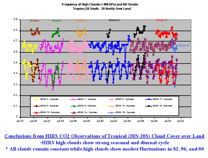
Cloud Frequency (high clouds and all clouds) Over Land (20oN - 20oS):
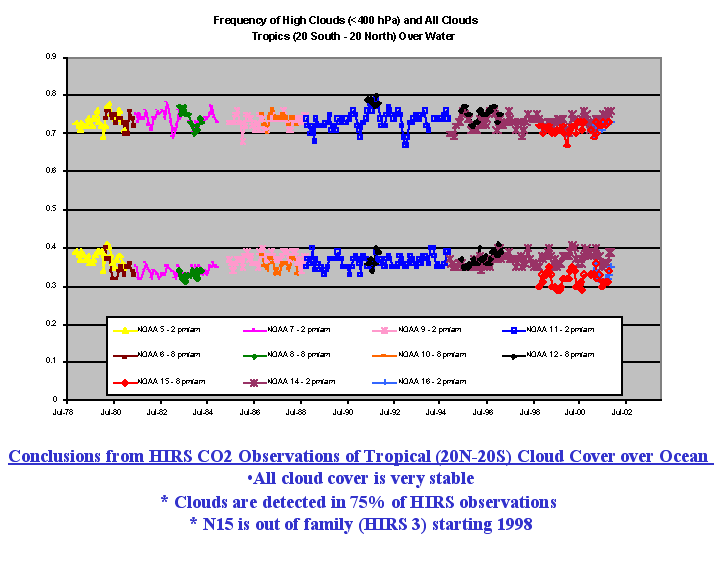
Cloud Frequency (high clouds and all clouds) Over Water (20oN - 20oS):
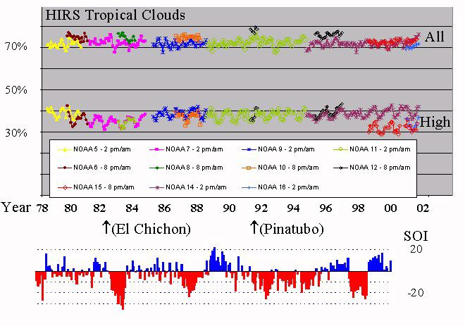
The SOI (Southern Oscillation Index) is the barometric pressure difference between Tahiti and Darwin, Australia. It's used as an index with ElNino - ENSO. The SOI is an indicator of the strength of the trades in the west pacific.
Baum, B. A. and B. A. Wielicki: Cirrus cloud retrieval using infrared sounding data: Multilevel cloud errors. J. Appl. Meteor., 33, No. 1, 107-117, 1994.
Menzel, W. P., W. L. Smith, and T. R. Stewart: Improved cloud motion wind vector and altitude assignment using VAS. J. Appl. Meteorol., 22, 377-384, 1983.
Menzel, W. P., D. P. Wylie, and K. I. Strabala: Seasonal and diurnal changes in cirrus clouds as seen in four years of observations with the VAS. J.. Appl. Meteorol., 31, 370-385, 1992.
Wylie, D. P., and H. Woolf: The Diurnal Cycle of Upper Tropospheric Clouds Measured by GOES-VAS and the ISCCP, Monthly Wea. Rev., 130, 171-179, 2002.
Wylie, D.P., W. P. Menzel, H. M. Woolf, K. I. Strabala, 1994: Four Years of Global Cirrus Cloud Statistics Using HIRS., J. Climate, 7, 1972-1986.
Wylie, D. P. and W. P. Menzel: Eight years of global high cloud statistics using HIRS. J. Climate ,12 , 170-184, 1999.
Wielicki, B. A. and J. A. Coakley, Jr. Cloud retrieval using infared sounder data: Error analysis. J. Appl. Meteorol., 20, 157-169, 1981.